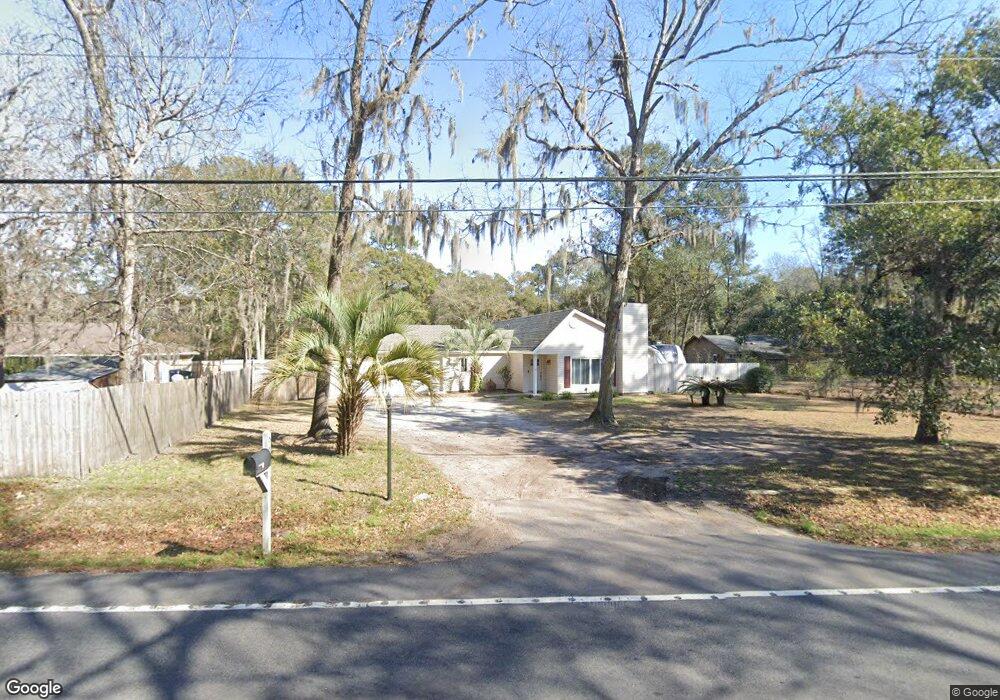
662 Sams Point Rd Beaufort, SC 29907
Estimated Value: $341,513 - $391,000
3
Beds
2
Baths
1,310
Sq Ft
$273/Sq Ft
Est. Value
About This Home
This home is located at 662 Sams Point Rd, Beaufort, SC 29907 and is currently estimated at $358,128, approximately $273 per square foot. 662 Sams Point Rd is a home located in Beaufort County with nearby schools including Lady's Island Elementary School, Lady's Island Middle School, and Beaufort High School.
Ownership History
Date
Name
Owned For
Owner Type
Purchase Details
Closed on
Mar 24, 2005
Sold by
Wainright Patrick H and Wainright Cheryl L
Bought by
Martin James P and Martin Angela M
Current Estimated Value
Home Financials for this Owner
Home Financials are based on the most recent Mortgage that was taken out on this home.
Original Mortgage
$156,750
Outstanding Balance
$79,099
Interest Rate
5.54%
Mortgage Type
Fannie Mae Freddie Mac
Estimated Equity
$279,029
Purchase Details
Closed on
May 28, 2002
Sold by
Cody John M and Cody Diane C
Bought by
Wainright Patrick H and Wainright Cheryl L
Home Financials for this Owner
Home Financials are based on the most recent Mortgage that was taken out on this home.
Original Mortgage
$130,050
Interest Rate
6.77%
Mortgage Type
VA
Create a Home Valuation Report for This Property
The Home Valuation Report is an in-depth analysis detailing your home's value as well as a comparison with similar homes in the area
Home Values in the Area
Average Home Value in this Area
Purchase History
| Date | Buyer | Sale Price | Title Company |
|---|---|---|---|
| Martin James P | $165,000 | -- | |
| Wainright Patrick H | $127,500 | -- |
Source: Public Records
Mortgage History
| Date | Status | Borrower | Loan Amount |
|---|---|---|---|
| Open | Martin James P | $156,750 | |
| Previous Owner | Wainright Patrick H | $130,050 |
Source: Public Records
Tax History Compared to Growth
Tax History
| Year | Tax Paid | Tax Assessment Tax Assessment Total Assessment is a certain percentage of the fair market value that is determined by local assessors to be the total taxable value of land and additions on the property. | Land | Improvement |
|---|---|---|---|---|
| 2024 | $1,143 | $10,920 | $1,440 | $9,480 |
| 2023 | $1,143 | $10,920 | $1,440 | $9,480 |
| 2022 | $1,075 | $7,160 | $1,344 | $5,816 |
| 2021 | $1,045 | $7,160 | $1,344 | $5,816 |
| 2020 | $1,034 | $7,160 | $1,344 | $5,816 |
| 2019 | $1,011 | $7,160 | $1,344 | $5,816 |
| 2018 | $976 | $6,550 | $0 | $0 |
| 2017 | $865 | $5,700 | $0 | $0 |
| 2016 | $846 | $5,700 | $0 | $0 |
| 2014 | $661 | $5,700 | $0 | $0 |
Source: Public Records
Map
Nearby Homes
- 9 Attaway Ln
- 47 Mary Elizabeth Dr
- 1 Pickens St
- 1 Royal Pines Blvd
- 77 Wade Hampton Dr
- 18 Hewlett Rd
- 19 Pickens St
- 591 Sams Point Rd
- 571 Sams Point Rd
- 13 Shallowford Downs
- 2 Venice Ct
- 47 Wade Hampton Dr
- 123 Francis Marion Cir
- 45 Westminster Place
- 59 Francis Marion Cir
- 525 Sams Point Rd
- 22 Egret Dr
- 8 Marsh Hawk Dr
- 15 Woods Ln
- 13 Woods Ln
- 31 Pine Run Trail
- 37 Pine Run Trail
- 1 Red Tip Rd
- 661 Sams Point Rd
- 30 Pine Run Trail
- 667 Sams Point Rd
- 2 White Dogwood Rd
- 657 Sams Point Rd
- 7 Red Tip Rd
- 4 White Dogwood Rd
- 671 Sams Point Rd
- 4 Red Tip Rd
- 2 Red Tip Rd
- 9 Red Tip Rd
- 651 Sams Point Rd
- 6 White Dogwood Rd
- 6 Red Tip Rd
- 8 White Dogwood Rd
- 675 Sams Point Rd
- 1 White Dogwood Rd