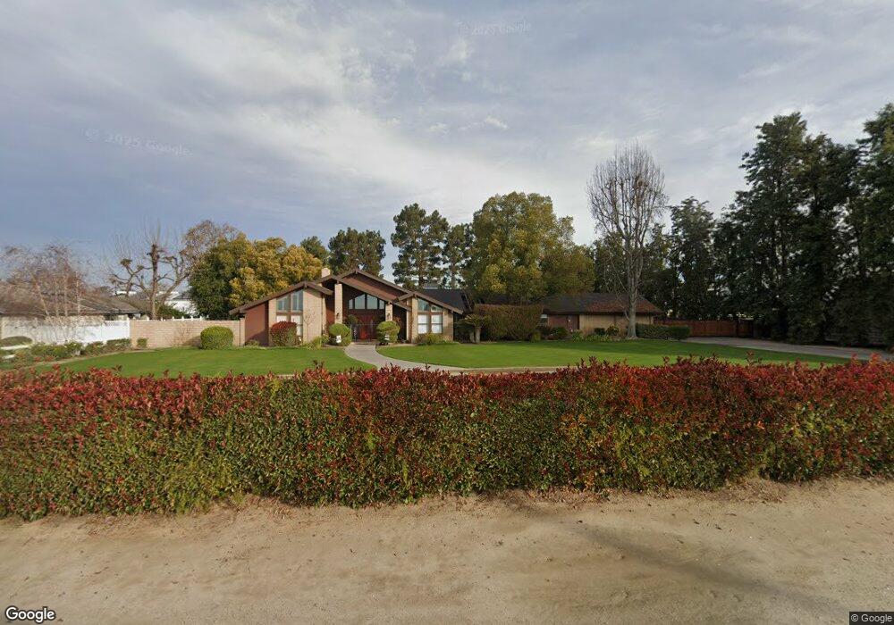
6620 Shafter Rd Bakersfield, CA 93313
Estimated Value: $652,000 - $836,000
3
Beds
2
Baths
2,460
Sq Ft
$302/Sq Ft
Est. Value
About This Home
This home is located at 6620 Shafter Rd, Bakersfield, CA 93313 and is currently estimated at $741,876, approximately $301 per square foot. 6620 Shafter Rd is a home located in Kern County with nearby schools including Lakeside School, General Shafter Elementary School, and Independence High School.
Ownership History
Date
Name
Owned For
Owner Type
Purchase Details
Closed on
Jun 9, 2021
Sold by
Eakle Michael H and Eakle Neva M
Bought by
Michael And Neva Eakle Family Trust and Eakle
Current Estimated Value
Purchase Details
Closed on
Sep 7, 2012
Sold by
Stokes C H and Stokes Marlene
Bought by
Eakle Michael H
Home Financials for this Owner
Home Financials are based on the most recent Mortgage that was taken out on this home.
Original Mortgage
$315,000
Interest Rate
3.47%
Create a Home Valuation Report for This Property
The Home Valuation Report is an in-depth analysis detailing your home's value as well as a comparison with similar homes in the area
Home Values in the Area
Average Home Value in this Area
Purchase History
| Date | Buyer | Sale Price | Title Company |
|---|---|---|---|
| Michael And Neva Eakle Family Trust | -- | None Listed On Document | |
| Eakle Michael H | $350,000 | First American Title Company |
Source: Public Records
Mortgage History
| Date | Status | Borrower | Loan Amount |
|---|---|---|---|
| Previous Owner | Eakle Michael H | $315,000 |
Source: Public Records
Tax History Compared to Growth
Tax History
| Year | Tax Paid | Tax Assessment Tax Assessment Total Assessment is a certain percentage of the fair market value that is determined by local assessors to be the total taxable value of land and additions on the property. | Land | Improvement |
|---|---|---|---|---|
| 2025 | $5,240 | $430,990 | $123,138 | $307,852 |
| 2024 | $5,112 | $422,540 | $120,724 | $301,816 |
| 2023 | $5,112 | $414,256 | $118,357 | $295,899 |
| 2022 | $4,992 | $406,135 | $116,037 | $290,098 |
| 2021 | $4,898 | $398,172 | $113,762 | $284,410 |
| 2020 | $4,826 | $394,090 | $112,596 | $281,494 |
| 2019 | $4,732 | $394,090 | $112,596 | $281,494 |
| 2018 | $4,600 | $378,789 | $108,225 | $270,564 |
| 2017 | $4,522 | $371,362 | $106,103 | $265,259 |
| 2016 | $3,992 | $364,081 | $104,023 | $260,058 |
| 2015 | $3,961 | $358,613 | $102,461 | $256,152 |
| 2014 | $3,874 | $351,589 | $100,454 | $251,135 |
Source: Public Records
Map
Nearby Homes
- 6521 Ryan Park Ct
- 7544 Clifford Ct
- 6706 Houghton Rd
- 15313 Gosford Rd
- 7925 Houghton Rd
- 7926 Bear Mountain Blvd
- 0 Bear Mountain Blvd
- 11217 Gosford Rd
- 15852 Wible Rd
- 6200 Whaleback Ave
- 5831 Mardal Ave
- 6021 Bogart Dr
- 5808 Esmerelda Ave
- 6028 Bogart Dr
- 6230 Taft Hwy
- 9402 Cobble Mountain Rd
- 9623 Kanosh Cobble Dr
- 6201 Cape Cod Ave
- 6115 Cape Cod Ave
- 4620 Taft Hwy
- 6670 Shafter Rd
- 14437 Ashe Rd
- 6710 Shafter Rd
- 14329 Ashe Rd
- 6800 Shafter Rd
- 6832 Shafter Rd
- 6809 Ryan Park Ct
- 6651 Ryan Park Ct
- 6900 Shafter Rd
- 6904 Shafter Rd Unit 10
- 6711 Ryan Park Ct
- 6934 Shafter Rd
- 6737 Ryan Park Ct
- 7008 Shafter Rd
- 6827 Ryan Park Ct
- 7022 Shafter Rd
- 6514 Ryan Park Ct
- 6704 Ryan Park Ct
- 0 Ryan Park Ct
- 11106 Ryan Park Ct