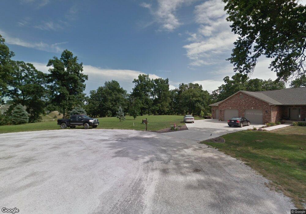
6630 Ryan Ct Cantrall, IL 62625
Estimated Value: $541,000 - $620,000
--
Bed
--
Bath
--
Sq Ft
1.33
Acres
About This Home
This home is located at 6630 Ryan Ct, Cantrall, IL 62625 and is currently estimated at $591,048. 6630 Ryan Ct is a home located in Sangamon County with nearby schools including Cantrall Elementary School, Cantrall Intermediate School, and Athens Junior High School.
Ownership History
Date
Name
Owned For
Owner Type
Purchase Details
Closed on
Apr 29, 2022
Sold by
Howard Ronald and Howard Stephanie
Bought by
Farmer Michael J and Farmer Marybeth A
Current Estimated Value
Home Financials for this Owner
Home Financials are based on the most recent Mortgage that was taken out on this home.
Original Mortgage
$416,000
Outstanding Balance
$339,631
Interest Rate
3.13%
Mortgage Type
New Conventional
Estimated Equity
$251,417
Purchase Details
Closed on
Dec 7, 2010
Purchase Details
Closed on
Feb 24, 2010
Purchase Details
Closed on
Aug 26, 2004
Create a Home Valuation Report for This Property
The Home Valuation Report is an in-depth analysis detailing your home's value as well as a comparison with similar homes in the area
Home Values in the Area
Average Home Value in this Area
Purchase History
| Date | Buyer | Sale Price | Title Company |
|---|---|---|---|
| Farmer Michael J | $520,000 | -- | |
| -- | $59,900 | -- | |
| -- | $55,000 | -- | |
| -- | $52,500 | -- |
Source: Public Records
Mortgage History
| Date | Status | Borrower | Loan Amount |
|---|---|---|---|
| Open | Farmer Michael J | $416,000 |
Source: Public Records
Tax History Compared to Growth
Tax History
| Year | Tax Paid | Tax Assessment Tax Assessment Total Assessment is a certain percentage of the fair market value that is determined by local assessors to be the total taxable value of land and additions on the property. | Land | Improvement |
|---|---|---|---|---|
| 2024 | $10,316 | $172,250 | $30,808 | $141,442 |
| 2023 | $9,818 | $159,329 | $28,497 | $130,832 |
| 2022 | $9,311 | $148,406 | $26,543 | $121,863 |
| 2021 | $9,266 | $141,488 | $25,306 | $116,182 |
| 2020 | $9,054 | $138,564 | $24,783 | $113,781 |
| 2019 | $8,792 | $137,519 | $24,596 | $112,923 |
| 2018 | $8,975 | $136,726 | $24,454 | $112,272 |
| 2017 | $8,754 | $135,225 | $24,186 | $111,039 |
| 2016 | $8,857 | $131,992 | $23,608 | $108,384 |
| 2015 | $3,346 | $50,806 | $23,300 | $27,506 |
| 2014 | $1,534 | $48,927 | $22,438 | $26,489 |
| 2013 | $1,498 | $22,135 | $22,135 | $0 |
Source: Public Records
Map
Nearby Homes
- 0 Presidential Lake Estates Unit RMACA1024912
- 6644 Reagan Dr
- 6555 Coolidge Dr
- 24862 Brookwood Hills Rd
- 1130 Cantrall Creek Rd
- 24689 Sumac Ln
- 61 Thistle Ridge
- 7919 Gooseberry Hill Dr Unit 1
- 34 N Wind Ln Unit 1
- 0 Green Haven Dr
- 3572 Betrus Unit 1
- 2996 Hazlett Rd Unit 1
- 3118 Moore Rd Unit 1
- 5008 Rock Rd Unit 1
- 3801 Eagle Claw Dr
- 10699 Ogden St
- 101 W Hawkeye Way
- 205 W Madison St
- 505 W Madison St
- 201 W Jefferson St
- 6631 Ryan Ct
- 0 Presidential Lake Estates Unit CA1003637
- 6675 Coolidge Dr
- 6655 Ryan Ct
- 6615 Coolidge Dr
- 6645 Coolidge Dr
- 6712 Ryan Ct
- 2970 Eisenhower Dr
- 0 Ryan Ct
- Lot 29 Ryan Ct
- 0 Eisenhower Dr
- 0 Eisenhower Dr
- 0 Eisenhower Dr
- Lot 27 Eisenhower Dr
- LOT 10 Eisenhower Dr
- 6701 Coolidge Dr
- 0 Coolidge Dr
- 0 Coolidge Dr
- 0 Coolidge Dr
- 6555 6587 Coolidge Dr