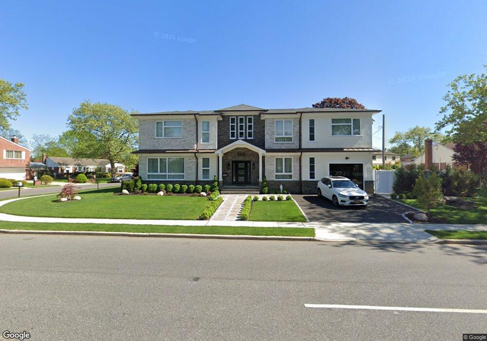
664 Laurel Dr West Hempstead, NY 11552
Estimated Value: $1,016,000
--
Bed
2
Baths
7,039
Sq Ft
$144/Sq Ft
Est. Value
About This Home
This home is located at 664 Laurel Dr, West Hempstead, NY 11552 and is currently estimated at $1,016,000, approximately $144 per square foot. 664 Laurel Dr is a home located in Nassau County with nearby schools including Chestnut Street School, West Hempstead Middle School, and West Hempstead Secondary School.
Ownership History
Date
Name
Owned For
Owner Type
Purchase Details
Closed on
Jun 19, 2013
Sold by
Silverstein David B
Bought by
Diaz Juan and Diaz Elvira
Current Estimated Value
Home Financials for this Owner
Home Financials are based on the most recent Mortgage that was taken out on this home.
Original Mortgage
$341,880
Outstanding Balance
$240,576
Interest Rate
3.25%
Mortgage Type
FHA
Estimated Equity
$775,424
Create a Home Valuation Report for This Property
The Home Valuation Report is an in-depth analysis detailing your home's value as well as a comparison with similar homes in the area
Home Values in the Area
Average Home Value in this Area
Purchase History
| Date | Buyer | Sale Price | Title Company |
|---|---|---|---|
| Diaz Juan | $420,000 | -- | |
| Diaz Juan | $420,000 | -- | |
| Diaz Juan | $420,000 | -- |
Source: Public Records
Mortgage History
| Date | Status | Borrower | Loan Amount |
|---|---|---|---|
| Open | Diaz Juan | $341,880 | |
| Closed | Diaz Juan | $341,880 |
Source: Public Records
Tax History Compared to Growth
Tax History
| Year | Tax Paid | Tax Assessment Tax Assessment Total Assessment is a certain percentage of the fair market value that is determined by local assessors to be the total taxable value of land and additions on the property. | Land | Improvement |
|---|---|---|---|---|
| 2025 | $12,059 | $430 | $430 | -- |
| 2024 | $3,557 | $430 | $430 | $0 |
| 2023 | $9,282 | $430 | $300 | $130 |
| 2022 | $9,282 | $541 | $377 | $164 |
| 2021 | $15,825 | $571 | $383 | $188 |
| 2020 | $12,652 | $696 | $558 | $138 |
| 2019 | $3,808 | $696 | $558 | $138 |
| 2018 | $3,649 | $696 | $0 | $0 |
| 2017 | $7,331 | $696 | $558 | $138 |
| 2016 | $10,824 | $696 | $532 | $164 |
| 2015 | $3,269 | $696 | $484 | $212 |
| 2014 | $3,269 | $696 | $484 | $212 |
| 2013 | $3,207 | $730 | $507 | $223 |
Source: Public Records
Map
Nearby Homes
- 771 Maple Place
- 1010 Hempstead Ave
- 618 Wall St
- 81 Gerard Ave W
- 899 Cleveland St
- 10 Atlas Ave
- 95 Dogwood Ave
- 853 Arthur St
- 71 Dogwood Ave
- 73 Parkview Place
- 13 Parkview Place
- 89 Parkview Place
- 722 Palmetto Dr
- 841 Harrison St
- 401 Ocean Ave
- 9 Coral Ct
- 70 Morris Ave
- 919 Pinelake Dr
- 4 Malverne Ave
- 924 Otsego Ct
- 677 Cornwell Ave
- 663 Laurel Dr
- 685 Cornwell Ave
- 694 Laurel Dr
- 791 Maple Place
- 677 Laurel Dr
- 792 Maple Place
- 687 Laurel Dr
- 706 Laurel Dr
- 693 Cornwell Ave
- 635 Cornwell Ave
- 684 Cornwell Ave
- 779 Maple Place
- 782 Maple Place
- 690 Cornwell Ave
- 714 Laurel Dr
- 701 Cornwell Ave
- 774 Maple Place
- 994 Hempstead Ave
- 696 Cornwell Ave