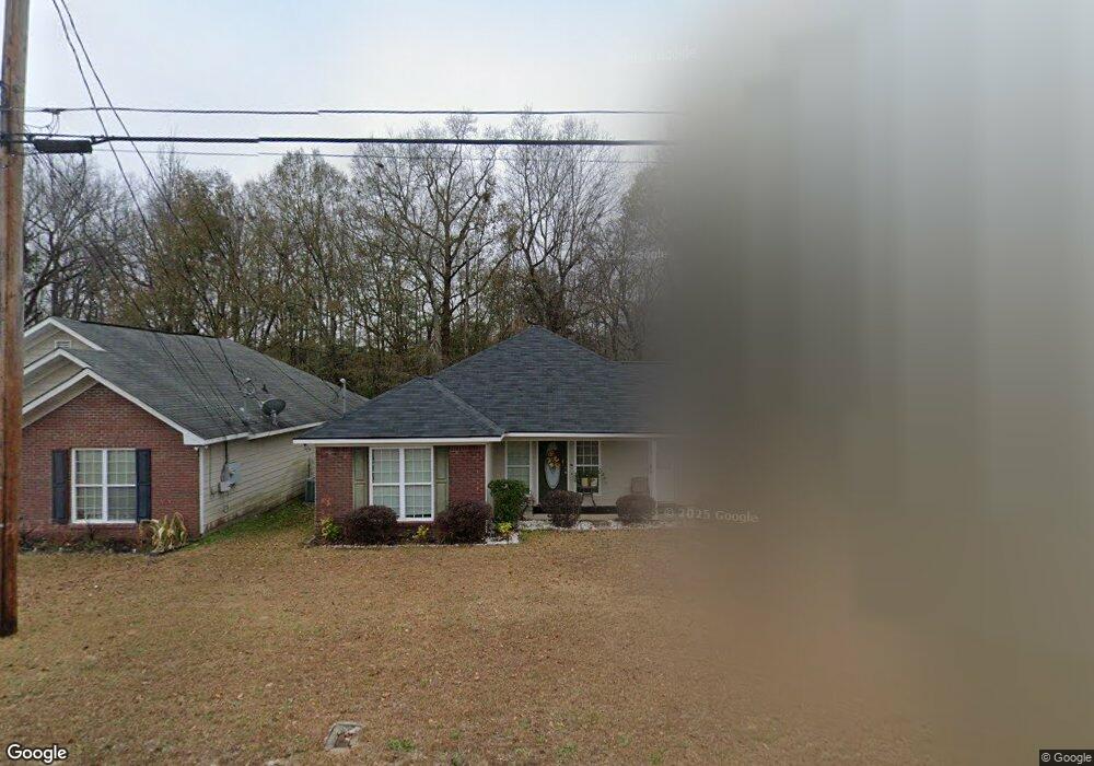
664 Mill Pond Dr Phenix City, AL 36870
Estimated Value: $189,000 - $201,306
3
Beds
2
Baths
1,362
Sq Ft
$142/Sq Ft
Est. Value
About This Home
This home is located at 664 Mill Pond Dr, Phenix City, AL 36870 and is currently estimated at $193,577, approximately $142 per square foot. 664 Mill Pond Dr is a home located in Russell County with nearby schools including Phenix City Elementary School, Phenix City Intermediate School, and South Girard School.
Ownership History
Date
Name
Owned For
Owner Type
Purchase Details
Closed on
Feb 7, 2008
Sold by
Kennefick Construction Inc
Bought by
Wilson Christian Demarco and Wilson Pamela D
Current Estimated Value
Home Financials for this Owner
Home Financials are based on the most recent Mortgage that was taken out on this home.
Original Mortgage
$125,542
Outstanding Balance
$78,314
Interest Rate
5.85%
Mortgage Type
Stand Alone First
Estimated Equity
$115,263
Create a Home Valuation Report for This Property
The Home Valuation Report is an in-depth analysis detailing your home's value as well as a comparison with similar homes in the area
Home Values in the Area
Average Home Value in this Area
Purchase History
| Date | Buyer | Sale Price | Title Company |
|---|---|---|---|
| Wilson Christian Demarco | -- | -- |
Source: Public Records
Mortgage History
| Date | Status | Borrower | Loan Amount |
|---|---|---|---|
| Open | Wilson Christian Demarco | $125,542 |
Source: Public Records
Tax History Compared to Growth
Tax History
| Year | Tax Paid | Tax Assessment Tax Assessment Total Assessment is a certain percentage of the fair market value that is determined by local assessors to be the total taxable value of land and additions on the property. | Land | Improvement |
|---|---|---|---|---|
| 2024 | $845 | $15,570 | $3,500 | $12,070 |
| 2023 | $839 | $15,475 | $3,500 | $11,975 |
| 2022 | $714 | $13,362 | $3,500 | $9,862 |
| 2021 | $562 | $10,783 | $2,500 | $8,283 |
| 2020 | $568 | $10,880 | $2,500 | $8,380 |
| 2019 | $515 | $9,980 | $2,500 | $7,480 |
| 2018 | $516 | $10,000 | $2,500 | $7,500 |
| 2017 | $1,208 | $10,160 | $2,500 | $7,660 |
| 2016 | $1,219 | $20,660 | $5,000 | $15,660 |
| 2015 | $1,234 | $20,925 | $5,000 | $15,925 |
| 2014 | $1,358 | $23,018 | $5,000 | $18,018 |
Source: Public Records
Map
Nearby Homes
- 589 Mill Pond Dr
- 103 Mill Pond St
- 23 Lake Ln
- 39 Springwood Dr
- 2 Woodland Dr
- 442 Lee Road 2170
- 4 Cedarwood Ln
- 275 Lee Road 2170
- 280 Mill Pond Dr
- 18 Springwood Dr
- 33 Lake Ct
- 4 Crestwood Ct
- 5 Springwood Dr
- 363 Mimosa Rd
- 22 Lee Road 2172
- 6 Alabama Ave
- 5 Tennessee Ave
- 8 Springwood Ct
- 9 Woodmere Ct
- 21 Whiterock Rd
- 674 Mill Pond Dr
- 654 Mill Pond Dr
- 684 Mill Pond Dr
- 655 Mill Pond Dr
- 665 Mill Pond Dr
- 645 Mill Pond Dr
- 694 Mill Pond Dr
- 628 Mill Pond Dr
- 675 Mill Pond Dr
- 18 Mill Pond St
- 616 Mill Pond Dr
- 30 Mill Pond St
- 15 Mill Pond Ct
- 695 Mill Pond Dr
- 13 Mill Pond Ct
- 604 Mill Pond Dr
- 714 Mill Pond Dr
- 601 Mill Pond Dr
- 17 Mill Pond Ct
- 11 Mill Pond Ct