Estimated Value: $254,000 - $357,000
3
Beds
2
Baths
2,142
Sq Ft
$144/Sq Ft
Est. Value
About This Home
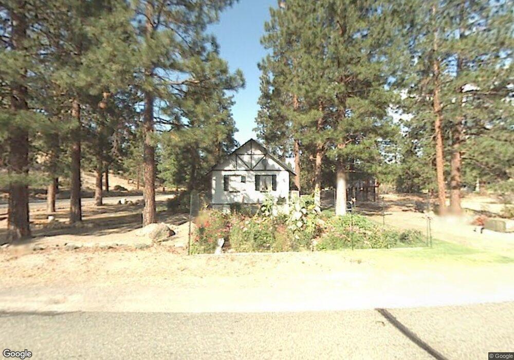
This home is located at 6643 Hogan Dr, Weed, CA 96094 and is currently estimated at $308,414, approximately $143 per square foot. 6643 Hogan Dr is a home located in Siskiyou County with nearby schools including Butteville Elementary School and Weed High School.
Ownership History
Date
Name
Owned For
Owner Type
Purchase Details
Closed on
Oct 28, 2021
Sold by
Kaufmann Joann M
Bought by
Kaufmann Joann Marie and The Joann M Kaufmann Living Tr
Current Estimated Value
Purchase Details
Closed on
Nov 29, 2006
Sold by
Kaufmann Glenn A
Bought by
Kaufmann Joann M
Home Financials for this Owner
Home Financials are based on the most recent Mortgage that was taken out on this home.
Original Mortgage
$182,000
Interest Rate
6.32%
Mortgage Type
Purchase Money Mortgage
Purchase Details
Closed on
Dec 10, 2002
Sold by
Kaufmann Joann M and Kaufmann Glenn A
Bought by
Kaufmann Glenn A and Kaufmann Joann M
Home Financials for this Owner
Home Financials are based on the most recent Mortgage that was taken out on this home.
Original Mortgage
$85,000
Interest Rate
6.06%
Create a Home Valuation Report for This Property
The Home Valuation Report is an in-depth analysis detailing your home's value as well as a comparison with similar homes in the area
Home Values in the Area
Average Home Value in this Area
Purchase History
| Date | Buyer | Sale Price | Title Company |
|---|---|---|---|
| Kaufmann Joann Marie | -- | None Available | |
| Kaufmann Joann M | -- | Mt Shasta Title & Escrow Co | |
| Kaufmann Glenn A | -- | Mt Shasta Title & Escrow |
Source: Public Records
Mortgage History
| Date | Status | Borrower | Loan Amount |
|---|---|---|---|
| Previous Owner | Kaufmann Joann M | $182,000 | |
| Previous Owner | Kaufmann Glenn A | $85,000 |
Source: Public Records
Tax History
| Year | Tax Paid | Tax Assessment Tax Assessment Total Assessment is a certain percentage of the fair market value that is determined by local assessors to be the total taxable value of land and additions on the property. | Land | Improvement |
|---|---|---|---|---|
| 2025 | $1,433 | $139,152 | $31,668 | $107,484 |
| 2023 | $1,433 | $133,751 | $30,440 | $103,311 |
| 2022 | $1,378 | $131,130 | $29,844 | $101,286 |
| 2021 | $1,354 | $128,559 | $29,259 | $99,300 |
| 2020 | $1,343 | $127,241 | $28,959 | $98,282 |
| 2019 | $1,316 | $124,747 | $28,392 | $96,355 |
| 2018 | $1,290 | $122,302 | $27,836 | $94,466 |
| 2017 | $1,267 | $119,905 | $27,291 | $92,614 |
| 2016 | $1,242 | $117,555 | $26,756 | $90,799 |
| 2015 | $1,225 | $115,791 | $26,355 | $89,436 |
| 2014 | $1,202 | $113,524 | $25,839 | $87,685 |
Source: Public Records
Map
Nearby Homes
- Unit 5-3 Lot 7 Wood Ct Unit 5-3
- 6308 Palmer Dr
- Unit 5-3 Lot 46 Brown Ct Unit 5-3
- Unit 5 Lot 12 Palmer Dr Unit 5
- Lot 205 Unt 5-3 Douglas Ct Unit 5-3
- Unit 5-4 Tennis Ct Unit 5
- Lots 55 & 56 Tennis Ct Unit 5-4
- 17325 Nicklaus Ct
- 0 Zen Mountain Unit 20250745
- 5-3 Lot 141 Hogan Dr Unit 5-3
- 5-3 Lot 162 Hogan Dr Unit 5-3
- Lots 186/187 Hogan Dr Unit 5-3
- Lot 88 Hogan Dr Unit 7-1
- 5845 Floyd Ct
- Lot 8 - 9 Harney Ct
- 17310 Blocker Ct
- Barber Ct. Lot 39 Unit 5
- 17344 Harney Ct
- 17440 Jack Rabbit Rd
- 5101 Possum Ct
- 6632 Hogan Dr
- 6644 Hogan Dr
- 6621 Hogan Dr
- 6215 Palmer Dr
- 6624 Hogan Dr
- 6138 Wood Ct
- Unit5-3 Lot 276 Palmer Dr Unit 5-3
- 6112 Palmer Dr
- 00 Wood Ct Unit 5-3
- 6104 Palmer Dr
- 6543 Hogan Dr
- 6140 Wood Ct
- 6602 Hogan Dr
- 6539 Hogan Dr
- 6224 Palmer Dr
- 6123 Wood Ct
- 6143 Wood Ct
- 6517 Hogan Dr
- 6236 Palmer Dr
- 5-3/5 Wood Ct Unit 5-3
Your Personal Tour Guide
Ask me questions while you tour the home.