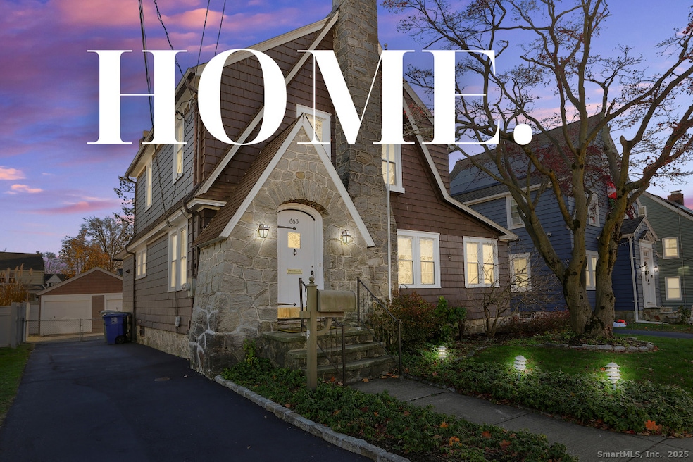
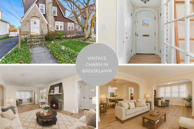

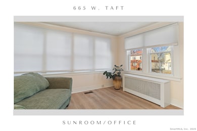
665 W Taft Ave Bridgeport, CT 06604
Brooklawn-Saint Vincent NeighborhoodEstimated payment $3,355/month
Highlights
- Very Popular Property
- Tudor Architecture
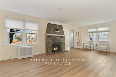
- 1 Fireplace
- Beach Access
- Attic
- Porch
About This Home
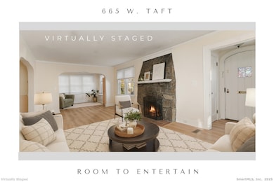
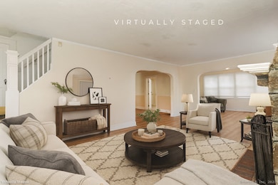
Surprise! A MAIN LEVEL PRIMARY suite-or versatile studio-steals the show in this charming Tudor-style stone and shingle home. Located in the desirable Brooklawn neighborhood, this beauty exudes curb appeal. The home offers character-rich details, modern updates, restored baths, and an easy, open flow throughout. The first-floor suite features soaring ceilings and generous natural light, ideal for an in-law setup, private office, or artist's workspace. Also found on the main level are formal living and dining rooms, a bright sunroom/office, a powder room, and a spacious kitchen that opens to the rear porch. Upstairs, you'll find two additional bedrooms with hardwood floors, a walk-in closet, and a beautifully renovated spa bath with soaking tub and wood open-shelved vanity. Exposed stairs leading to the upper level add charm and personality. With central air, a terrarium-style garden area, fenced and landscaped yard, gated driveway leading to a 2-car garage, and abundant storage, this home delivers comfort, character, and versatility.
Listing Agent
William Raveis Real Estate Brokerage Phone: (203) 650-1583 License #RES.0761852 Listed on: 12/03/2025

Co-Listing Agent
William Raveis Real Estate Brokerage Phone: (203) 650-1583 License #RES.0797747
Home Details
Home Type
- Single Family
Est. Annual Taxes
- $8,718
Year Built
- Built in 1920
Lot Details
- 6,534 Sq Ft Lot
- Property is zoned RA
Home Design
- Tudor Architecture
- Concrete Foundation
- Stone Foundation
- Frame Construction
- Asphalt Shingled Roof
- Shake Siding
- Stone Siding
- Stucco Exterior
Interior Spaces
- 2,636 Sq Ft Home
- 1 Fireplace
Kitchen
- Oven or Range
- Microwave
- Dishwasher
- Disposal
Bedrooms and Bathrooms
- 3 Bedrooms
- Soaking Tub
Laundry
- Laundry on main level
- Dryer
- Washer
Attic
- Storage In Attic
- Walkup Attic
Unfinished Basement
- Basement Fills Entire Space Under The House
- Interior Basement Entry
- Basement Storage
Parking
- 2 Car Garage
- Private Driveway
Outdoor Features
- Beach Access
- Patio
- Exterior Lighting
- Rain Gutters
- Porch
Location
- Property is near a golf course
Schools
- Geraldine Johnson Elementary School
- Bassick High School
Utilities
- Central Air
- Hot Water Heating System
- Heating System Uses Oil
- Hot Water Circulator
- Fuel Tank Located in Basement
- Cable TV Available
Listing and Financial Details
- Exclusions: See inclusion/exclusion disclosures.
- Assessor Parcel Number 21946
Map
Home Values in the Area
Average Home Value in this Area
Tax History
| Year | Tax Paid | Tax Assessment Tax Assessment Total Assessment is a certain percentage of the fair market value that is determined by local assessors to be the total taxable value of land and additions on the property. | Land | Improvement |
|---|---|---|---|---|
| 2025 | $8,718 | $200,640 | $79,490 | $121,150 |
| 2024 | $8,718 | $200,640 | $79,490 | $121,150 |
| 2023 | $8,718 | $200,640 | $79,490 | $121,150 |
| 2022 | $8,718 | $200,640 | $79,490 | $121,150 |
| 2021 | $8,718 | $200,640 | $79,490 | $121,150 |
| 2020 | $8,374 | $155,110 | $48,160 | $106,950 |
| 2019 | $8,374 | $155,110 | $48,160 | $106,950 |
| 2018 | $8,433 | $155,110 | $48,160 | $106,950 |
| 2017 | $8,433 | $155,110 | $48,160 | $106,950 |
| 2016 | $8,433 | $155,110 | $48,160 | $106,950 |
| 2015 | $8,403 | $199,120 | $53,430 | $145,690 |
| 2014 | $8,403 | $199,120 | $53,430 | $145,690 |
Property History
| Date | Event | Price | List to Sale | Price per Sq Ft |
|---|---|---|---|---|
| 12/03/2025 12/03/25 | For Sale | $499,000 | -- | $189 / Sq Ft |
Purchase History
| Date | Type | Sale Price | Title Company |
|---|---|---|---|
| Warranty Deed | $360,000 | -- | |
| Warranty Deed | $360,000 | -- | |
| Warranty Deed | $133,500 | -- | |
| Warranty Deed | $133,500 | -- |
Mortgage History
| Date | Status | Loan Amount | Loan Type |
|---|---|---|---|
| Open | $251,250 | No Value Available | |
| Closed | $288,000 | No Value Available |
Source: SmartMLS
MLS Number: 24142665
APN: BRID-001352-000024
Disclaimer: Certain information contained herein is derived from information provided by parties other than Homes.com. All information provided is deemed reliable, but is not guaranteed to be accurate and should be independently verified.
![]() IDX information is provided exclusively for personal, non-commercial use, and may not be used for any purpose other than to identify prospective properties consumers may be interested in purchasing. Information is deemed reliable but not guaranteed.
IDX information is provided exclusively for personal, non-commercial use, and may not be used for any purpose other than to identify prospective properties consumers may be interested in purchasing. Information is deemed reliable but not guaranteed.
- 1213 Wood Ave
- 1480 Capitol Ave Unit 811
- 2345 Park Ave
- 356 Taft Ave
- 1275 Capitol Ave
- 605 Brooklawn Ave
- 2445 Park Ave Unit 23
- 184 Pacific St
- 687 Wood Ave
- 1872 North Ave Unit 1874
- 1473 Wood Ave
- 100 Lorraine St
- 76 Suburban Ave
- 566 Wood Ave
- 860 Briarwood Ave
- 2625 Park Ave Unit 12L
- 2625 Park Ave Unit 5N
- 201 High Ridge Dr
- 2370 North Ave Unit 4C
- 2370 North Ave Unit 12G
- 1387 Norman St Unit 1389
- 64 Wade St Unit 1
- 63 Eaton St Unit 3
- 169 Birdseye St Unit c2
- 759 Wood Ave
- 155 Birdseye St Unit c7
- 57 Grasso Terrace
- 61 Villa Ave
- 1908 North Ave
- 1921 North Ave
- 155 Brooklawn Ave
- 1770 Park Ave Unit 1B
- 70 Renwick Place
- 2625 Park Ave Unit 14D
- 2625 Park Ave Unit 1L
- 2625 Park Ave Unit 12J
- 366 Suburban Ave
- 164 Cleveland Ave Unit 2nd
- 2340 North Ave
- 2600 Park Ave Unit 6H