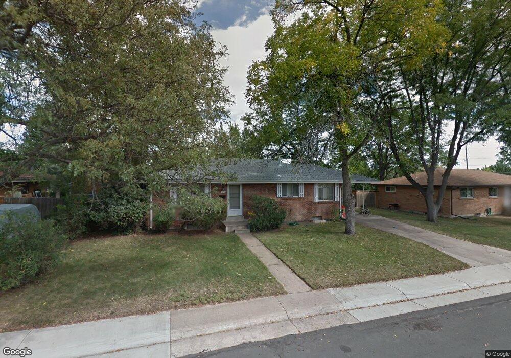
6670 S Grant St Centennial, CO 80121
West Centennial NeighborhoodEstimated Value: $489,856 - $588,000
--
Bed
2
Baths
1,188
Sq Ft
$456/Sq Ft
Est. Value
About This Home
This home is located at 6670 S Grant St, Centennial, CO 80121 and is currently estimated at $541,964, approximately $456 per square foot. 6670 S Grant St is a home located in Arapahoe County with nearby schools including Euclid Middle School and Heritage High School.
Ownership History
Date
Name
Owned For
Owner Type
Purchase Details
Closed on
Dec 28, 2018
Sold by
Suder Beth E and Suder Richard L
Bought by
Rb Grant Llc
Current Estimated Value
Purchase Details
Closed on
Apr 21, 2006
Sold by
Suder Beth E
Bought by
Suder Beth E and Suder Richard L
Home Financials for this Owner
Home Financials are based on the most recent Mortgage that was taken out on this home.
Original Mortgage
$125,000
Interest Rate
6.32%
Mortgage Type
Fannie Mae Freddie Mac
Purchase Details
Closed on
Mar 24, 1999
Sold by
Suder Richard L
Bought by
Suder Beth E
Purchase Details
Closed on
Jun 1, 1982
Sold by
Conversion Arapco
Bought by
Conversion Arapco
Purchase Details
Closed on
Nov 1, 1979
Sold by
Conversion Arapco
Bought by
Conversion Arapco
Purchase Details
Closed on
Jul 4, 1776
Bought by
Conversion Arapco
Create a Home Valuation Report for This Property
The Home Valuation Report is an in-depth analysis detailing your home's value as well as a comparison with similar homes in the area
Home Values in the Area
Average Home Value in this Area
Purchase History
| Date | Buyer | Sale Price | Title Company |
|---|---|---|---|
| Rb Grant Llc | -- | None Available | |
| Suder Beth E | -- | Land Title | |
| Suder Beth E | -- | -- | |
| Conversion Arapco | -- | -- | |
| Conversion Arapco | -- | -- | |
| Conversion Arapco | -- | -- |
Source: Public Records
Mortgage History
| Date | Status | Borrower | Loan Amount |
|---|---|---|---|
| Previous Owner | Suder Beth E | $125,000 |
Source: Public Records
Tax History Compared to Growth
Tax History
| Year | Tax Paid | Tax Assessment Tax Assessment Total Assessment is a certain percentage of the fair market value that is determined by local assessors to be the total taxable value of land and additions on the property. | Land | Improvement |
|---|---|---|---|---|
| 2024 | $3,287 | $30,706 | -- | -- |
| 2023 | $3,287 | $30,706 | $0 | $0 |
| 2022 | $3,161 | $27,863 | $0 | $0 |
| 2021 | $3,159 | $27,863 | $0 | $0 |
| 2020 | $3,129 | $28,393 | $0 | $0 |
| 2019 | $2,960 | $28,393 | $0 | $0 |
| 2018 | $2,311 | $22,198 | $0 | $0 |
| 2017 | $2,132 | $22,198 | $0 | $0 |
| 2016 | $1,829 | $18,284 | $0 | $0 |
| 2015 | $1,831 | $18,284 | $0 | $0 |
| 2014 | -- | $15,227 | $0 | $0 |
| 2013 | -- | $14,120 | $0 | $0 |
Source: Public Records
Map
Nearby Homes
- 6654 S Lee Ct
- 6532 S Sherman St
- 6825 S Penrose Ct
- 6691 S Wellington Ct
- 140 E Highline Cir Unit 105
- 100 E Highline Cir Unit 105
- 50 E Highline Cir Unit 102
- 309 E Highline Cir Unit 102
- 6840 S Broadway
- 190 E Highline Cir Unit 302
- 980 E Briarwood Cir N
- 6928 S Broadway
- 6695 S Ogden St
- 6751 S Downing Cir W
- 7011 S Washington St
- 888 E Davies Ave
- 236 E Fair Ln
- 6142 S Logan Place
- 6130 S Pennsylvania St
- 6102 S Logan Place
- 6680 S Grant St
- 6660 S Grant St
- 6671 S Logan St
- 6681 S Logan St
- 6661 S Logan St
- 6650 S Grant St
- 6690 S Grant St
- 6673 S Grant St
- 6683 S Grant St
- 6663 S Grant St
- 6691 S Logan St
- 6651 S Logan St
- 6693 S Grant St
- 6653 S Grant St
- 6640 S Grant St
- 6641 S Logan St
- 6672 S Sherman St
- 6678 S Logan St
- 6662 S Sherman St
- 6688 S Logan St