Estimated Value: $680,000 - $886,000
3
Beds
3
Baths
3,570
Sq Ft
$217/Sq Ft
Est. Value
About This Home
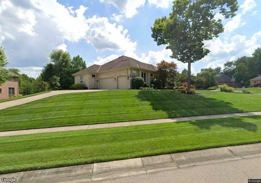
This home is located at 6671 Gove Ct, Mason, OH 45040 and is currently estimated at $775,821, approximately $217 per square foot. 6671 Gove Ct is a home located in Warren County with nearby schools including Mason Intermediate Elementary School, Mason Middle School, and William Mason High School.
Ownership History
Date
Name
Owned For
Owner Type
Purchase Details
Closed on
Feb 20, 2023
Sold by
Mcatee David Michael
Bought by
Carin K Mcatee Revocable Trust
Current Estimated Value
Purchase Details
Closed on
Sep 15, 2021
Sold by
Stevens G Lorraine G and Stevens Arlen L
Bought by
Mcatee David Michael and Mcatee Carin Kay
Purchase Details
Closed on
Oct 6, 2005
Sold by
Stevens G Lorraine and Stevens Arlen L
Bought by
Stevens Arlen L and Lorraine Stevens G
Purchase Details
Closed on
Jul 31, 2003
Sold by
Hines Griffin Joint Venture Pll
Bought by
Stevens G Lorraine
Create a Home Valuation Report for This Property
The Home Valuation Report is an in-depth analysis detailing your home's value as well as a comparison with similar homes in the area
Home Values in the Area
Average Home Value in this Area
Purchase History
| Date | Buyer | Sale Price | Title Company |
|---|---|---|---|
| Carin K Mcatee Revocable Trust | -- | -- | |
| Mcatee David Michael | $500,000 | Prodigy Title Agency | |
| Stevens Arlen L | -- | -- | |
| Stevens G Lorraine | $95,600 | -- |
Source: Public Records
Tax History Compared to Growth
Tax History
| Year | Tax Paid | Tax Assessment Tax Assessment Total Assessment is a certain percentage of the fair market value that is determined by local assessors to be the total taxable value of land and additions on the property. | Land | Improvement |
|---|---|---|---|---|
| 2024 | $11,171 | $257,190 | $42,000 | $215,190 |
| 2023 | $10,700 | $202,867 | $43,260 | $159,607 |
| 2022 | $10,519 | $202,867 | $43,260 | $159,607 |
| 2021 | $9,592 | $202,867 | $43,260 | $159,607 |
| 2020 | $10,918 | $196,959 | $42,000 | $154,959 |
| 2019 | $10,130 | $196,959 | $42,000 | $154,959 |
| 2018 | $9,939 | $196,959 | $42,000 | $154,959 |
| 2017 | $10,135 | $181,773 | $36,869 | $144,904 |
| 2016 | $10,309 | $181,773 | $36,869 | $144,904 |
| 2015 | $10,498 | $181,773 | $36,869 | $144,904 |
| 2014 | $10,498 | $173,110 | $35,110 | $138,000 |
| 2013 | $10,521 | $207,070 | $42,000 | $165,070 |
Source: Public Records
Map
Nearby Homes
- 6826 Waterbury Ln
- 6577 Rosegate Ct
- 4669 Morris Ct
- 5280 Sunset Ridge Dr
- 5088 Harvestdale Dr
- 5017 Ainsley Dr
- 4109 Maxwell Dr
- 5513 Harvestdale Dr
- 6752 Tyler Ct
- 7112 Larkspur Ln
- 4253 Maxwell Dr
- 8256 Cherry Laurel Dr
- 6260 Lake Front
- 5383 Wheatmore Ct
- 5065 Birchwood Farms Dr
- 6134 Lakelyn Unit 300D
- 5787 Southwater Dr Unit 206H
- 5836 Bayswater Dr
- 5837 Southwater Dr Unit 205F
- 6525 Rosewood Ln