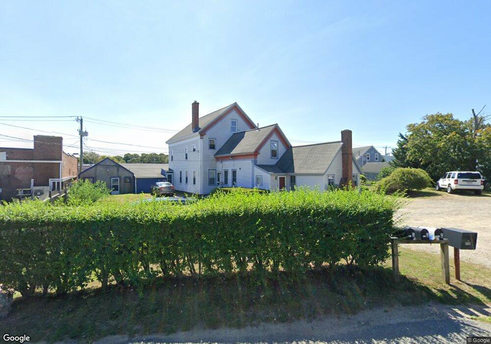
668 Main St Dennis Port, MA 02639
Dennis Port NeighborhoodEstimated Value: $1,197,637
--
Bed
--
Bath
6,225
Sq Ft
$192/Sq Ft
Est. Value
About This Home
This home is located at 668 Main St, Dennis Port, MA 02639 and is currently estimated at $1,197,637, approximately $192 per square foot. 668 Main St is a home located in Barnstable County with nearby schools including Dennis-Yarmouth Regional High School and St. Pius X. School.
Ownership History
Date
Name
Owned For
Owner Type
Purchase Details
Closed on
May 1, 2015
Sold by
Barlow Robert D and Lee Mary A
Bought by
Rej Rt
Current Estimated Value
Purchase Details
Closed on
Jun 16, 2004
Sold by
Larson Prop Inc
Bought by
Barlow Mary Ann and Barlow Robert D
Home Financials for this Owner
Home Financials are based on the most recent Mortgage that was taken out on this home.
Original Mortgage
$337,500
Interest Rate
6.12%
Mortgage Type
Commercial
Create a Home Valuation Report for This Property
The Home Valuation Report is an in-depth analysis detailing your home's value as well as a comparison with similar homes in the area
Home Values in the Area
Average Home Value in this Area
Purchase History
Date | Buyer | Sale Price | Title Company |
---|---|---|---|
Rej Rt | $650,000 | -- | |
Barlow Mary Ann | $450,000 | -- |
Source: Public Records
Mortgage History
Date | Status | Borrower | Loan Amount |
---|---|---|---|
Previous Owner | Barlow Robert | $34,925 | |
Previous Owner | Parker River Rt | $250,000 | |
Previous Owner | Barlow Mary Ann | $337,500 | |
Previous Owner | Fallon Anne | $125,000 |
Source: Public Records
Tax History Compared to Growth
Tax History
Year | Tax Paid | Tax Assessment Tax Assessment Total Assessment is a certain percentage of the fair market value that is determined by local assessors to be the total taxable value of land and additions on the property. | Land | Improvement |
---|---|---|---|---|
2025 | $3,057 | $705,900 | $262,400 | $443,500 |
2024 | $2,985 | $680,000 | $252,900 | $427,100 |
2023 | $3,023 | $647,400 | $240,900 | $406,500 |
2022 | $3,420 | $610,700 | $227,200 | $383,500 |
2021 | $3,557 | $589,900 | $222,800 | $367,100 |
2020 | $3,528 | $578,300 | $220,200 | $358,100 |
2019 | $3,449 | $559,000 | $200,100 | $358,900 |
2018 | $3,557 | $561,000 | $200,100 | $360,900 |
2017 | $3,450 | $561,000 | $200,100 | $360,900 |
2016 | $3,513 | $538,000 | $180,100 | $357,900 |
2015 | $3,546 | $554,100 | $180,100 | $374,000 |
2014 | -- | $461,900 | $180,100 | $281,800 |
Source: Public Records
Map
Nearby Homes
- 0 Division St
- 47 Telegraph Rd Unit 1
- 8 South St
- 41 Edwards Ave
- 212 Upper County Rd Unit 2A
- 40 North St
- 18 South St Unit 1-2
- 16 Edwards Ave
- 9 Edwards Ave Unit A5
- 38 Mill St
- 9 Country Ln
- 7 Burton Ave
- 45 Route 28
- 174 Upper County Rd Unit 1-16
- 12 Candlewood Ln Unit 2-2
- 12 Candlewood Ln Unit 2-Feb
- 3 Newcomb Dr
- 136 Depot St
- 32 Canning Terrace
- 668 Main St
- 678 Main St
- 682 Main St
- 682 Main St
- 401 Upper County Rd
- 662 Main St
- 662 Massachusetts 28
- 676 Main (Route 28) St
- 411 Upper County Rd
- 421 Upper County Rd
- 684 Main St
- 497 Upper County Rd
- 485 Upper County Rd
- 652 Main St
- 246 Upper County Rd
- 16 Telegraph Rd
- 683 Massachusetts 28
- 250 Upper County Rd
- 254 Upper County Rd
- 537 Upper County Rd