Estimated Value: $223,000 - $285,000
3
Beds
2
Baths
1,040
Sq Ft
$241/Sq Ft
Est. Value
About This Home
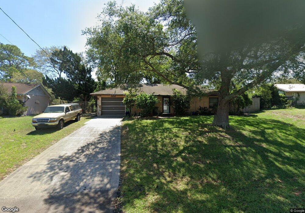
This home is located at 6689 Cairo Rd, Cocoa, FL 32927 and is currently estimated at $250,334, approximately $240 per square foot. 6689 Cairo Rd is a home located in Brevard County with nearby schools including Enterprise Elementary School, Space Coast Junior/Senior High School, and Sculptor Charter School.
Ownership History
Date
Name
Owned For
Owner Type
Purchase Details
Closed on
Oct 11, 2023
Sold by
Szucs Kay E
Bought by
Kay E Szucs Trust and Szucs
Current Estimated Value
Purchase Details
Closed on
Dec 16, 1993
Sold by
Szucs Richard L and Szucs Kay E
Bought by
Szucs Kay E
Purchase Details
Closed on
Nov 4, 1993
Sold by
Horgan Debra Neon and Glady Debra Neon
Bought by
Szucs Richard L and Szucs Kay E
Purchase Details
Closed on
Nov 1, 1993
Sold by
Kiet Nancy G Rachelle and Glady Nancy G Rachelle
Bought by
Szucs Richard L and Szucs Kay E
Create a Home Valuation Report for This Property
The Home Valuation Report is an in-depth analysis detailing your home's value as well as a comparison with similar homes in the area
Home Values in the Area
Average Home Value in this Area
Purchase History
| Date | Buyer | Sale Price | Title Company |
|---|---|---|---|
| Kay E Szucs Trust | $100 | None Listed On Document | |
| Szucs Kay E | -- | -- | |
| Szucs Richard L | -- | -- | |
| Szucs Richard L | -- | -- |
Source: Public Records
Tax History
| Year | Tax Paid | Tax Assessment Tax Assessment Total Assessment is a certain percentage of the fair market value that is determined by local assessors to be the total taxable value of land and additions on the property. | Land | Improvement |
|---|---|---|---|---|
| 2025 | $865 | $68,820 | -- | -- |
| 2024 | $910 | $66,890 | -- | -- |
| 2023 | $910 | $64,950 | $0 | $0 |
| 2022 | $862 | $63,060 | $0 | $0 |
| 2021 | $864 | $61,230 | $0 | $0 |
| 2020 | $831 | $60,390 | $0 | $0 |
| 2019 | $780 | $59,040 | $0 | $0 |
| 2018 | $781 | $57,940 | $0 | $0 |
| 2017 | $784 | $56,750 | $0 | $0 |
| 2016 | $789 | $55,590 | $18,000 | $37,590 |
| 2015 | $794 | $55,210 | $15,000 | $40,210 |
| 2014 | $799 | $54,780 | $11,000 | $43,780 |
Source: Public Records
Map
Nearby Homes
- 6760 Cairo Rd
- 6815 Bryant Rd
- 6615 Dock Ave
- 00 Unknown
- 6450 Ember Ave
- 6581 Bancroft Ave
- 6620 Grissom Pkwy
- 7065 Hundred Acre Dr
- 5555 Brandon St
- 6481 La Brea Ave
- 0000 Grissom Pkwy
- 5155 Mayflower St
- 6398 Cable Ave
- 5075 Carter St
- 6438 Hudson Rd
- 6990 Bryant Rd
- 6375 Cable Ave
- 5165 Patricia St
- 5080 Mayflower St
- 5220 Holden Rd
Your Personal Tour Guide
Ask me questions while you tour the home.