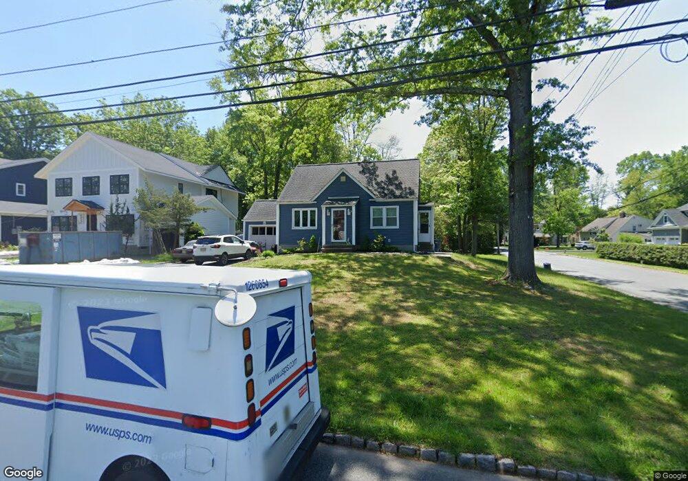
67 Commonwealth Ave New Providence, NJ 07974
Estimated Value: $653,591 - $897,000
--
Bed
--
Bath
1,200
Sq Ft
$632/Sq Ft
Est. Value
About This Home
This home is located at 67 Commonwealth Ave, New Providence, NJ 07974 and is currently estimated at $757,898, approximately $631 per square foot. 67 Commonwealth Ave is a home located in Union County with nearby schools including New Providence High School and The Academy of Our Lady of Peace.
Ownership History
Date
Name
Owned For
Owner Type
Purchase Details
Closed on
Sep 12, 2017
Sold by
Harrington Michael and Grande Shirley
Bought by
Harrington Michael G and Harrington Shirley
Current Estimated Value
Home Financials for this Owner
Home Financials are based on the most recent Mortgage that was taken out on this home.
Original Mortgage
$406,491
Outstanding Balance
$347,909
Interest Rate
4.87%
Mortgage Type
FHA
Estimated Equity
$409,989
Purchase Details
Closed on
Jun 20, 2005
Sold by
Schraft Greg
Bought by
Harrington Michael and Grande Shirley
Home Financials for this Owner
Home Financials are based on the most recent Mortgage that was taken out on this home.
Original Mortgage
$360,800
Interest Rate
5.37%
Mortgage Type
Adjustable Rate Mortgage/ARM
Purchase Details
Closed on
Oct 9, 1998
Sold by
Schraft Greg and Graham Cynthia
Bought by
Schraft Greg
Purchase Details
Closed on
Feb 17, 1998
Sold by
Marron Thomas P and Marron Dina M
Bought by
Schraft Greg and Graham Cynthia
Home Financials for this Owner
Home Financials are based on the most recent Mortgage that was taken out on this home.
Original Mortgage
$176,800
Interest Rate
6.85%
Create a Home Valuation Report for This Property
The Home Valuation Report is an in-depth analysis detailing your home's value as well as a comparison with similar homes in the area
Home Values in the Area
Average Home Value in this Area
Purchase History
| Date | Buyer | Sale Price | Title Company |
|---|---|---|---|
| Harrington Michael G | -- | None Available | |
| Harrington Michael | $451,000 | -- | |
| Schraft Greg | -- | -- | |
| Schraft Greg | $221,000 | Chicago Title Insurance Co |
Source: Public Records
Mortgage History
| Date | Status | Borrower | Loan Amount |
|---|---|---|---|
| Open | Harrington Michael G | $406,491 | |
| Closed | Harrington Michael | $360,800 | |
| Previous Owner | Schraft Greg | $176,800 |
Source: Public Records
Tax History Compared to Growth
Tax History
| Year | Tax Paid | Tax Assessment Tax Assessment Total Assessment is a certain percentage of the fair market value that is determined by local assessors to be the total taxable value of land and additions on the property. | Land | Improvement |
|---|---|---|---|---|
| 2025 | $10,164 | $196,900 | $106,200 | $90,700 |
| 2024 | $9,859 | $196,900 | $106,200 | $90,700 |
| 2023 | $9,859 | $196,900 | $106,200 | $90,700 |
| 2022 | $9,723 | $196,900 | $106,200 | $90,700 |
| 2021 | $9,652 | $196,900 | $106,200 | $90,700 |
| 2020 | $9,648 | $196,900 | $106,200 | $90,700 |
| 2019 | $9,589 | $196,900 | $106,200 | $90,700 |
| 2018 | $9,540 | $196,900 | $106,200 | $90,700 |
| 2017 | $9,384 | $196,900 | $106,200 | $90,700 |
| 2016 | $9,252 | $196,900 | $106,200 | $90,700 |
| 2015 | $9,124 | $196,900 | $106,200 | $90,700 |
| 2014 | $8,987 | $196,900 | $106,200 | $90,700 |
Source: Public Records
Map
Nearby Homes
- 100 Commonwealth Ave
- 29 Walton Ave
- 5 Kincaid Ln
- 197 Elkwood Ave
- 32 Charnwood Rd
- 1200 Springfield Ave Unit 1B
- 17B Heritage Dr Unit B
- 283 Riveredge Dr
- 21G Heritage Dr Unit G
- 2F Terrace Dr Unit F
- 14 Holmes Oval
- 45 Runnymede Rd
- 131 van Houton Ave
- 146 Riveredge Dr
- 17 Hilltop Terrace
- 54 Badgley Dr
- 85 Southern Blvd
- 36 Terrace Rd
- 16 Terrace Rd
- 32 Marion Ave
- 71 Commonwealth Ave
- 14 Crescent Dr
- 57 Commonwealth Ave
- 77 Commonwealth Ave
- 22 Crescent Dr
- 15 Crescent Dr
- 51 Commonwealth Ave
- 81 Commonwealth Ave
- 19 Crescent Dr
- 30 Crescent Dr
- 64 Commonwealth Ave
- 70 Commonwealth Ave
- 58 Commonwealth Ave
- 47 Commonwealth Ave
- 87 Commonwealth Ave
- 23 Crescent Dr
- 54 Commonwealth Ave
- 36 Crescent Dr
- 80 Commonwealth Ave
- 53 Osborne Ave