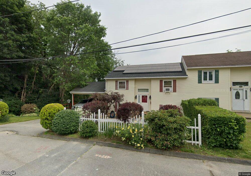
67 Fielding St Worcester, MA 01603
Webster Square NeighborhoodEstimated Value: $326,000 - $445,000
3
Beds
2
Baths
1,532
Sq Ft
$251/Sq Ft
Est. Value
About This Home
This home is located at 67 Fielding St, Worcester, MA 01603 and is currently estimated at $384,005, approximately $250 per square foot. 67 Fielding St is a home located in Worcester County with nearby schools including Jacob Hiatt Magnet School, Chandler Magnet, and Heard Street Discovery Academy.
Ownership History
Date
Name
Owned For
Owner Type
Purchase Details
Closed on
Nov 19, 2007
Sold by
Donaldson-Cole Beverly
Bought by
Donaldson-Cole Beverly and Cole Gladstone
Current Estimated Value
Purchase Details
Closed on
Apr 24, 1991
Sold by
Haye Trevor K
Bought by
Donaldson Beverly D
Create a Home Valuation Report for This Property
The Home Valuation Report is an in-depth analysis detailing your home's value as well as a comparison with similar homes in the area
Home Values in the Area
Average Home Value in this Area
Purchase History
| Date | Buyer | Sale Price | Title Company |
|---|---|---|---|
| Donaldson-Cole Beverly | $112,000 | -- | |
| Donaldson Beverly D | $112,000 | -- |
Source: Public Records
Mortgage History
| Date | Status | Borrower | Loan Amount |
|---|---|---|---|
| Previous Owner | Donaldson Beverly D | $52,000 | |
| Previous Owner | Donaldson Beverly D | $33,300 | |
| Previous Owner | Donaldson Beverly D | $10,000 | |
| Previous Owner | Donaldson Beverly D | $81,600 |
Source: Public Records
Tax History Compared to Growth
Tax History
| Year | Tax Paid | Tax Assessment Tax Assessment Total Assessment is a certain percentage of the fair market value that is determined by local assessors to be the total taxable value of land and additions on the property. | Land | Improvement |
|---|---|---|---|---|
| 2025 | $3,370 | $255,500 | $82,600 | $172,900 |
| 2024 | $3,281 | $238,600 | $82,600 | $156,000 |
| 2023 | $3,100 | $216,200 | $71,800 | $144,400 |
| 2022 | $2,777 | $182,600 | $57,500 | $125,100 |
| 2021 | $2,890 | $177,500 | $46,000 | $131,500 |
| 2020 | $2,824 | $166,100 | $45,600 | $120,500 |
| 2019 | $2,819 | $156,600 | $39,800 | $116,800 |
| 2018 | $2,821 | $149,200 | $39,800 | $109,400 |
| 2017 | $2,677 | $139,300 | $39,800 | $99,500 |
| 2016 | $2,667 | $129,400 | $28,900 | $100,500 |
| 2015 | $2,597 | $129,400 | $28,900 | $100,500 |
| 2014 | $2,528 | $129,400 | $28,900 | $100,500 |
Source: Public Records
Map
Nearby Homes
- 1511 Main St Unit C405
- 1511 Main St Unit C306
- 46 Locust St
- 1 Ludlow St
- 118 Mccarthy Ave
- 76 Parsons Hill Dr Unit A
- 24 Ludlow St
- 45 Wildwood Ave
- 26 Mildred Ave
- 41 Ledgecrest Dr
- 45 Ledgecrest Dr
- 68 Crest Cir
- 23 South St
- 19 South St
- 28 Alsada Dr
- 114 Henshaw St
- 53 James St
- 336 Wildwood Ave
- 57 1st St
- 500 Main St
- 0 Fielding St Unit 70863072
- 69 Fielding St
- 1554 Main St
- 1550 Main St
- 1552 Main St
- 63 Fielding St
- 71 Fielding St
- 73 Fielding St
- 1 Fielding St
- 1 Fielding St Unit 2
- 2 Fielding St
- 2 Fielding St Unit 1
- 1A Great Post Rd
- 3 Fielding St
- 61 Fielding St
- 4 Fielding St
- 66 Fielding St
- 1558-1560 Main St
- 1546 Main St
- 1556 Main St