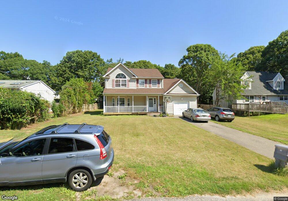
67 Palmetto Dr Shirley, NY 11967
Estimated Value: $560,112 - $653,000
3
Beds
2
Baths
2,066
Sq Ft
$298/Sq Ft
Est. Value
About This Home
This home is located at 67 Palmetto Dr, Shirley, NY 11967 and is currently estimated at $615,278, approximately $297 per square foot. 67 Palmetto Dr is a home located in Suffolk County with nearby schools including John S. Hobart Elementary School, William Paca Middle School, and William Floyd High School.
Ownership History
Date
Name
Owned For
Owner Type
Purchase Details
Closed on
Jun 1, 2004
Sold by
Enna Construction Inc
Bought by
Enin Ebenezer
Current Estimated Value
Home Financials for this Owner
Home Financials are based on the most recent Mortgage that was taken out on this home.
Original Mortgage
$67,200
Outstanding Balance
$33,638
Interest Rate
6.25%
Mortgage Type
Credit Line Revolving
Estimated Equity
$581,640
Purchase Details
Closed on
Nov 12, 2003
Sold by
Devine John and Ball Debora
Bought by
Enna Construction Inc
Purchase Details
Closed on
Jan 16, 2003
Sold by
Enna Construction Inc
Bought by
Devine John and Ball Debora
Home Financials for this Owner
Home Financials are based on the most recent Mortgage that was taken out on this home.
Original Mortgage
$276,350
Interest Rate
6.09%
Create a Home Valuation Report for This Property
The Home Valuation Report is an in-depth analysis detailing your home's value as well as a comparison with similar homes in the area
Home Values in the Area
Average Home Value in this Area
Purchase History
| Date | Buyer | Sale Price | Title Company |
|---|---|---|---|
| Enin Ebenezer | $336,000 | Fidelity National Title Insu | |
| Enna Construction Inc | $294,900 | -- | |
| Devine John | $290,900 | Fidelity National Title Ins |
Source: Public Records
Mortgage History
| Date | Status | Borrower | Loan Amount |
|---|---|---|---|
| Open | Enin Ebenezer | $67,200 | |
| Closed | Enin Ebenezer | $268,800 | |
| Previous Owner | Devine John | $276,350 |
Source: Public Records
Tax History Compared to Growth
Tax History
| Year | Tax Paid | Tax Assessment Tax Assessment Total Assessment is a certain percentage of the fair market value that is determined by local assessors to be the total taxable value of land and additions on the property. | Land | Improvement |
|---|---|---|---|---|
| 2024 | $8,558 | $2,300 | $320 | $1,980 |
| 2023 | $8,558 | $2,300 | $320 | $1,980 |
| 2022 | $9,036 | $2,300 | $320 | $1,980 |
| 2021 | $9,036 | $2,300 | $320 | $1,980 |
| 2020 | $9,289 | $2,300 | $320 | $1,980 |
| 2019 | $9,289 | $0 | $0 | $0 |
| 2018 | $8,777 | $2,300 | $320 | $1,980 |
| 2017 | $8,777 | $2,300 | $320 | $1,980 |
| 2016 | $8,756 | $2,300 | $320 | $1,980 |
| 2015 | -- | $2,300 | $320 | $1,980 |
| 2014 | -- | $2,300 | $320 | $1,980 |
Source: Public Records
Map
Nearby Homes
- 71 Palmetto Dr
- 74 Palmetto Dr
- 305 Commack Rd
- 38 Johns Neck Rd
- 55 Pinewood Dr
- 279 Commack Rd
- 277 Commack Rd
- 40 Pinewood Dr
- N/C Fairview Dr
- 9 Brushwood Dr
- 31 Harrison Dr
- 344 Elm Rd W
- 96 Baybright Dr
- 27 Pinewood Dr
- 205 William Floyd Pkwy
- 94 Baybright Dr E
- 30 Johns Neck Rd
- 6 Bogota Rd
- 516 Neighborhood Rd
- 514 Neighborhood Rd