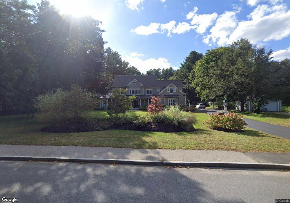
67 Woburn St Andover, MA 01810
Estimated Value: $1,461,000 - $1,781,000
4
Beds
4
Baths
4,111
Sq Ft
$391/Sq Ft
Est. Value
About This Home
This home is located at 67 Woburn St, Andover, MA 01810 and is currently estimated at $1,605,927, approximately $390 per square foot. 67 Woburn St is a home located in Essex County with nearby schools including South Elementary School, Doherty Middle School, and Andover High School.
Ownership History
Date
Name
Owned For
Owner Type
Purchase Details
Closed on
Dec 24, 2014
Sold by
67 Woburn Street T
Bought by
Doyle James B
Current Estimated Value
Home Financials for this Owner
Home Financials are based on the most recent Mortgage that was taken out on this home.
Original Mortgage
$650,000
Outstanding Balance
$499,361
Interest Rate
4%
Mortgage Type
Purchase Money Mortgage
Estimated Equity
$1,106,566
Purchase Details
Closed on
Mar 9, 2012
Sold by
Croteau Rita M
Bought by
67 Woburn Street T
Purchase Details
Closed on
Nov 2, 1999
Sold by
Boutin-Skene Patricia
Bought by
Wheeler Lawrence W and Wheeler Lorraine F
Home Financials for this Owner
Home Financials are based on the most recent Mortgage that was taken out on this home.
Original Mortgage
$240,000
Interest Rate
7.78%
Mortgage Type
Purchase Money Mortgage
Create a Home Valuation Report for This Property
The Home Valuation Report is an in-depth analysis detailing your home's value as well as a comparison with similar homes in the area
Home Values in the Area
Average Home Value in this Area
Purchase History
| Date | Buyer | Sale Price | Title Company |
|---|---|---|---|
| Doyle James B | $430,000 | -- | |
| 67 Woburn Street T | -- | -- | |
| Wheeler Lawrence W | $380,000 | -- |
Source: Public Records
Mortgage History
| Date | Status | Borrower | Loan Amount |
|---|---|---|---|
| Open | Doyle James B | $650,000 | |
| Previous Owner | Wheeler Lawrence W | $240,000 |
Source: Public Records
Tax History Compared to Growth
Tax History
| Year | Tax Paid | Tax Assessment Tax Assessment Total Assessment is a certain percentage of the fair market value that is determined by local assessors to be the total taxable value of land and additions on the property. | Land | Improvement |
|---|---|---|---|---|
| 2024 | $18,111 | $1,406,100 | $458,100 | $948,000 |
| 2023 | $17,463 | $1,278,400 | $414,100 | $864,300 |
| 2022 | $16,571 | $1,135,000 | $361,800 | $773,200 |
| 2021 | $16,006 | $1,046,800 | $330,000 | $716,800 |
| 2020 | $15,429 | $1,027,900 | $322,200 | $705,700 |
| 2019 | $15,424 | $1,010,100 | $313,100 | $697,000 |
| 2018 | $14,813 | $947,100 | $301,700 | $645,400 |
| 2017 | $14,228 | $937,300 | $296,100 | $641,200 |
| 2016 | $11,041 | $745,000 | $296,100 | $448,900 |
| 2015 | $6,567 | $438,700 | $285,200 | $153,500 |
Source: Public Records
Map
Nearby Homes