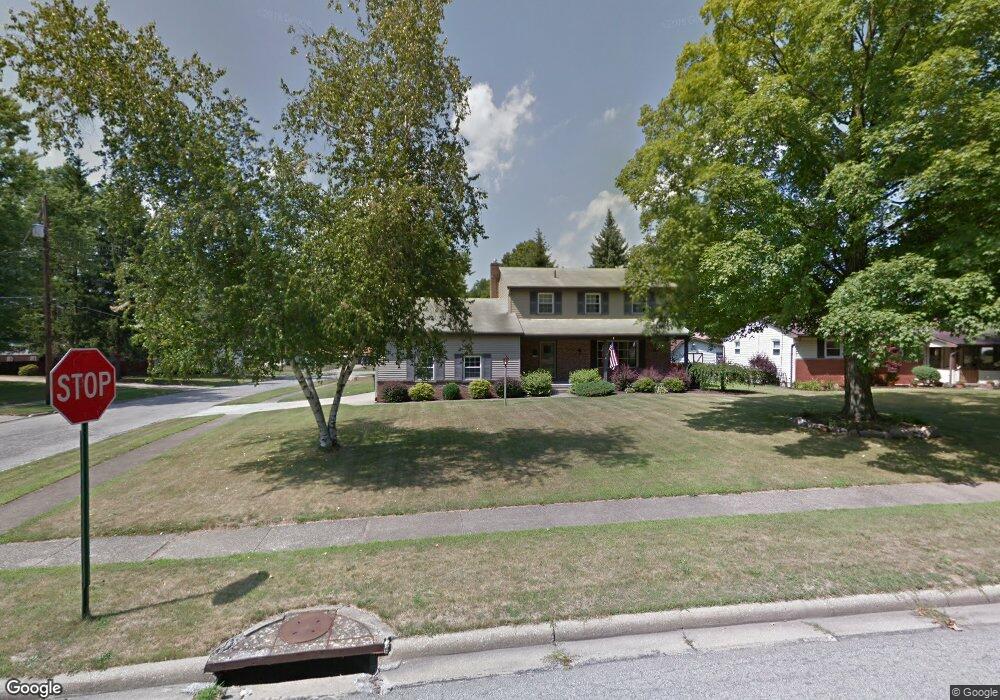
670 Maple Ridge Dr Youngstown, OH 44512
Estimated Value: $237,031 - $267,000
3
Beds
2
Baths
1,882
Sq Ft
$136/Sq Ft
Est. Value
About This Home
This home is located at 670 Maple Ridge Dr, Youngstown, OH 44512 and is currently estimated at $256,258, approximately $136 per square foot. 670 Maple Ridge Dr is a home located in Mahoning County with nearby schools including Robinwood Lane Elementary School, Boardman Glenwood Junior High School, and Boardman High School.
Ownership History
Date
Name
Owned For
Owner Type
Purchase Details
Closed on
Apr 27, 2012
Sold by
Wilson David A and Wilson Sharon L
Bought by
Wilsion Sharon L
Current Estimated Value
Home Financials for this Owner
Home Financials are based on the most recent Mortgage that was taken out on this home.
Original Mortgage
$95,000
Outstanding Balance
$66,374
Interest Rate
4.08%
Mortgage Type
New Conventional
Estimated Equity
$189,884
Purchase Details
Closed on
May 26, 1965
Bought by
Wilson Clarence M and N A
Create a Home Valuation Report for This Property
The Home Valuation Report is an in-depth analysis detailing your home's value as well as a comparison with similar homes in the area
Home Values in the Area
Average Home Value in this Area
Purchase History
| Date | Buyer | Sale Price | Title Company |
|---|---|---|---|
| Wilsion Sharon L | -- | Reliable Title Agency Inc | |
| Wilson Clarence M | -- | -- |
Source: Public Records
Mortgage History
| Date | Status | Borrower | Loan Amount |
|---|---|---|---|
| Open | Wilsion Sharon L | $95,000 |
Source: Public Records
Tax History Compared to Growth
Tax History
| Year | Tax Paid | Tax Assessment Tax Assessment Total Assessment is a certain percentage of the fair market value that is determined by local assessors to be the total taxable value of land and additions on the property. | Land | Improvement |
|---|---|---|---|---|
| 2024 | $3,454 | $68,020 | $8,620 | $59,400 |
| 2023 | $3,408 | $68,020 | $8,620 | $59,400 |
| 2022 | $2,769 | $42,140 | $7,000 | $35,140 |
| 2021 | $2,771 | $42,140 | $7,000 | $35,140 |
| 2020 | $2,785 | $42,140 | $7,000 | $35,140 |
| 2019 | $2,705 | $36,320 | $6,030 | $30,290 |
| 2018 | $2,332 | $36,320 | $6,030 | $30,290 |
| 2017 | $2,321 | $36,320 | $6,030 | $30,290 |
| 2016 | $2,327 | $36,170 | $6,030 | $30,140 |
| 2015 | $2,281 | $36,170 | $6,030 | $30,140 |
| 2014 | $2,288 | $36,170 | $6,030 | $30,140 |
| 2013 | $2,259 | $36,170 | $6,030 | $30,140 |
Source: Public Records
Map
Nearby Homes
- 642 Oakridge Dr
- 707 Oakridge Dr
- 6785 Tanglewood Dr
- 6001 Applecrest Dr
- 772 Teakwood Dr
- 6278 Appleridge Dr
- 796 Edenridge Dr
- 792 Forest Ridge Dr
- 6229 Appleridge Dr
- 197 Mathews Rd Unit B
- 0 Mathews Rd Unit 5038026
- 424 Mathews Rd
- 857 Maple Ridge Dr
- 785 Terraview Dr
- 178 Mathews Rd
- 928 Edenridge Dr
- 0 Moyer Ave
- 167 Afton Ave
- 88 Arlene Ave
- 268 Erskine Ave
- 676 Maple Ridge Dr
- 657 Forest Ridge Dr
- 663 Forest Ridge Dr
- 6230 Foxridge Dr
- 682 Maple Ridge Dr
- 6242 Foxridge Dr
- 651 Forest Ridge Dr
- 669 Forest Ridge Dr
- 677 Maple Ridge Dr
- 688 Maple Ridge Dr
- 645 Forest Ridge Dr
- 666 Oakridge Dr
- 675 Forest Ridge Dr
- 674 Oakridge Dr
- 683 Maple Ridge Dr
- 660 Oakridge Dr
- 694 Maple Ridge Dr
- 654 Oakridge Dr
- 680 Oakridge Dr
- 656 Forest Ridge Dr