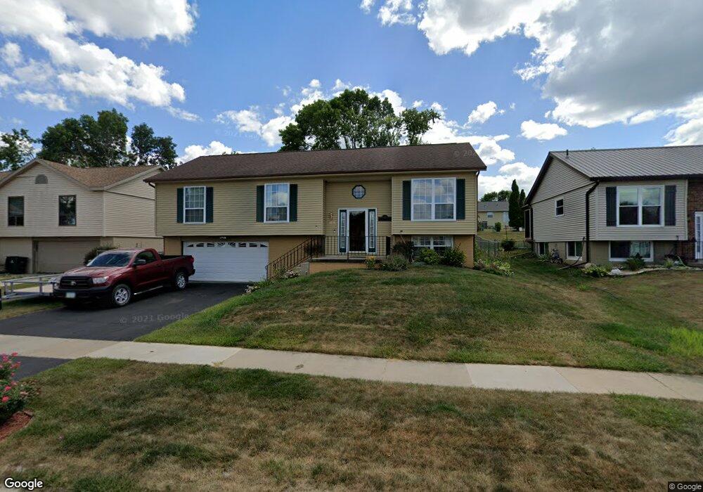
6705 Boulder Dr NW Cedar Rapids, IA 52405
Cherry Hill Park NeighborhoodEstimated Value: $232,521 - $287,000
3
Beds
3
Baths
1,380
Sq Ft
$191/Sq Ft
Est. Value
About This Home
This home is located at 6705 Boulder Dr NW, Cedar Rapids, IA 52405 and is currently estimated at $263,380, approximately $190 per square foot. 6705 Boulder Dr NW is a home located in Linn County with nearby schools including West Willow Elementary School, Taft Middle School, and Thomas Jefferson High School.
Ownership History
Date
Name
Owned For
Owner Type
Purchase Details
Closed on
Dec 3, 1999
Sold by
Kent Scott E and Kent Judith M
Bought by
Heisler Steven R and Heisler Marni A
Current Estimated Value
Home Financials for this Owner
Home Financials are based on the most recent Mortgage that was taken out on this home.
Original Mortgage
$106,100
Interest Rate
8.21%
Create a Home Valuation Report for This Property
The Home Valuation Report is an in-depth analysis detailing your home's value as well as a comparison with similar homes in the area
Home Values in the Area
Average Home Value in this Area
Purchase History
| Date | Buyer | Sale Price | Title Company |
|---|---|---|---|
| Heisler Steven R | $128,000 | -- |
Source: Public Records
Mortgage History
| Date | Status | Borrower | Loan Amount |
|---|---|---|---|
| Previous Owner | Heisler Steven R | $106,100 |
Source: Public Records
Tax History
| Year | Tax Paid | Tax Assessment Tax Assessment Total Assessment is a certain percentage of the fair market value that is determined by local assessors to be the total taxable value of land and additions on the property. | Land | Improvement |
|---|---|---|---|---|
| 2025 | $3,450 | $235,700 | $45,700 | $190,000 |
| 2024 | $3,664 | $208,600 | $42,400 | $166,200 |
| 2023 | $3,664 | $205,400 | $39,200 | $166,200 |
| 2022 | $3,332 | $182,600 | $35,900 | $146,700 |
| 2021 | $3,508 | $169,800 | $35,900 | $133,900 |
| 2020 | $3,508 | $167,600 | $35,900 | $131,700 |
| 2019 | $3,256 | $159,600 | $29,400 | $130,200 |
| 2018 | $3,162 | $159,600 | $29,400 | $130,200 |
| 2017 | $3,299 | $155,200 | $29,400 | $125,800 |
| 2016 | $3,299 | $155,200 | $29,400 | $125,800 |
| 2015 | $3,303 | $155,227 | $29,376 | $125,851 |
| 2014 | $3,118 | $155,227 | $29,376 | $125,851 |
| 2013 | $3,046 | $155,227 | $29,376 | $125,851 |
Source: Public Records
Map
Nearby Homes
- 6664 Sand Ct SW
- 108 Atwood Dr SW
- 320 Stoney Creek Rd NW
- 7013 Pleasant Ridge Dr SW
- 6319 Eastview Ave SW
- 6235 Eastview Ave SW
- 145 Belvedere Dr NW
- 916 Blue Stone St NW
- 818 High Point Dr SW
- 159 Crestridge Dr NW
- 6118 Greenbriar Ln SW Unit D
- 614 Grey Slate Dr SW
- 6907 Rock Wood Dr SW
- 620 Grey Slate Dr SW
- 6916 Rock Wood Dr SW
- 1590 Stoney Pt Rd & 6600 16th Ave SW
- 135 Eastview Dr NW
- 632 Grey Slate Dr SW
- 6925 Rock Wood Dr SW
- 456 Mayberry Dr NW
- 6629 Boulder Dr NW
- 6715 Boulder Dr NW
- 218 Sand Ln NW
- 6621 Boulder Dr NW
- 222 Sand Ln NW
- 6723 Boulder Dr NW
- 214 Sand Ln NW
- 226 Sand Ln NW
- 6704 Boulder Dr NW
- 6712 Boulder Dr NW
- 6628 Boulder Dr NW
- 6613 Boulder Dr NW
- 6733 Boulder Dr NW
- 6722 Boulder Dr NW
- 6620 Boulder Dr NW
- 210 Sand Ln NW
- 230 Sand Ln NW
- 6732 Boulder Dr NW
- 6805 Boulder Dr NW
- 318 Stone Hedge Dr NW
Your Personal Tour Guide
Ask me questions while you tour the home.