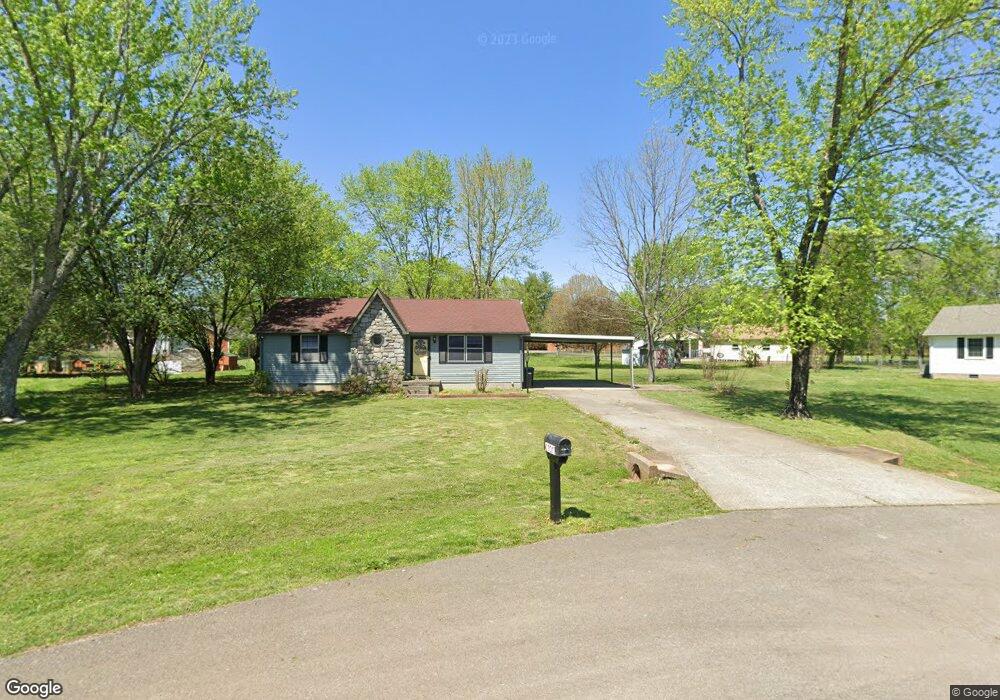
6707 Amanda Way Murfreesboro, TN 37129
Estimated Value: $288,270 - $871,000
--
Bed
1
Bath
1,059
Sq Ft
$414/Sq Ft
Est. Value
About This Home
This home is located at 6707 Amanda Way, Murfreesboro, TN 37129 and is currently estimated at $438,068, approximately $413 per square foot. 6707 Amanda Way is a home located in Rutherford County with nearby schools including Stewartsboro Elementary School, Rocky Fork Middle School, and Smyrna High School.
Ownership History
Date
Name
Owned For
Owner Type
Purchase Details
Closed on
Jul 2, 2024
Sold by
Milam Mackensy
Bought by
Brown Darren L and Brown Robert
Current Estimated Value
Home Financials for this Owner
Home Financials are based on the most recent Mortgage that was taken out on this home.
Original Mortgage
$242,250
Outstanding Balance
$239,329
Interest Rate
6.94%
Mortgage Type
Credit Line Revolving
Estimated Equity
$198,739
Purchase Details
Closed on
Aug 29, 2022
Sold by
Teresa Perry
Bought by
Milam Mackensy and Grosch Christina
Home Financials for this Owner
Home Financials are based on the most recent Mortgage that was taken out on this home.
Original Mortgage
$213,750
Interest Rate
5.54%
Mortgage Type
New Conventional
Purchase Details
Closed on
Dec 18, 1995
Bought by
Debbie Wright
Create a Home Valuation Report for This Property
The Home Valuation Report is an in-depth analysis detailing your home's value as well as a comparison with similar homes in the area
Home Values in the Area
Average Home Value in this Area
Purchase History
| Date | Buyer | Sale Price | Title Company |
|---|---|---|---|
| Brown Darren L | $885,000 | Lighthouse Title | |
| Milam Mackensy | $225,000 | None Listed On Document | |
| Debbie Wright | -- | -- |
Source: Public Records
Mortgage History
| Date | Status | Borrower | Loan Amount |
|---|---|---|---|
| Open | Brown Darren L | $242,250 | |
| Previous Owner | Milam Mackensy | $213,750 |
Source: Public Records
Tax History Compared to Growth
Tax History
| Year | Tax Paid | Tax Assessment Tax Assessment Total Assessment is a certain percentage of the fair market value that is determined by local assessors to be the total taxable value of land and additions on the property. | Land | Improvement |
|---|---|---|---|---|
| 2025 | $1,008 | $53,700 | $13,750 | $39,950 |
| 2024 | $1,008 | $53,700 | $13,750 | $39,950 |
| 2023 | $1,008 | $53,700 | $13,750 | $39,950 |
| 2022 | $819 | $50,700 | $13,750 | $36,950 |
| 2021 | $493 | $34,775 | $7,000 | $27,775 |
| 2020 | $493 | $34,775 | $7,000 | $27,775 |
| 2019 | $493 | $34,775 | $7,000 | $27,775 |
| 2018 | $493 | $34,775 | $0 | $0 |
| 2017 | $493 | $22,325 | $0 | $0 |
| 2016 | $493 | $22,325 | $0 | $0 |
| 2015 | $532 | $22,325 | $0 | $0 |
| 2014 | $498 | $22,325 | $0 | $0 |
| 2013 | -- | $20,100 | $0 | $0 |
Source: Public Records
Map
Nearby Homes
- 6612 Scenic Dr
- 4529 Baywood Ave
- 8607 Hooper St
- 611 Cheyenne Ct
- 5423 Colonial Cir
- 8815 West St
- 9238 Burleson Ln
- 6903 Cooks Ave
- 801 Becham Kenneth Cir
- 4436 Alpine Way
- 1239 Rimrock Rd
- 7121 Corner Dr
- 4408 Alpine Way
- 7127 Corner Dr
- 5311 Florence Rd
- 1142 Remuda Cir
- 8932 Burleson Ln Unit 8934
- 437 Burton Farms Dr
- 1214 Emmie Reece Dr
- 433 Burton Farms Dr