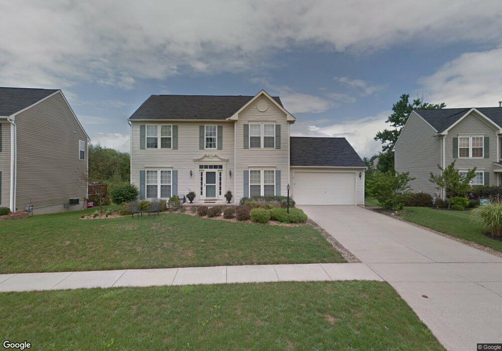
671 Brookside Ln Northfield, OH 44067
Estimated Value: $360,000 - $420,000
3
Beds
3
Baths
2,068
Sq Ft
$190/Sq Ft
Est. Value
About This Home
This home is located at 671 Brookside Ln, Northfield, OH 44067 and is currently estimated at $391,991, approximately $189 per square foot. 671 Brookside Ln is a home located in Summit County with nearby schools including Lee Eaton Elementary School, Nordonia Middle School, and Nordonia High School.
Ownership History
Date
Name
Owned For
Owner Type
Purchase Details
Closed on
Feb 22, 2010
Sold by
Bond Dewayne Eric and Bond Amy C
Bought by
Kilberg Derek and Kilberg Gina
Current Estimated Value
Home Financials for this Owner
Home Financials are based on the most recent Mortgage that was taken out on this home.
Original Mortgage
$180,736
Outstanding Balance
$118,198
Interest Rate
5.11%
Mortgage Type
VA
Estimated Equity
$273,793
Purchase Details
Closed on
Jun 14, 2002
Sold by
Nvr Inc
Bought by
Bond Dewayne Eric
Home Financials for this Owner
Home Financials are based on the most recent Mortgage that was taken out on this home.
Original Mortgage
$198,666
Interest Rate
6.7%
Purchase Details
Closed on
Feb 28, 2002
Sold by
Rolling Brooke Development Inc
Bought by
Nvr Inc and Ryan Homes
Create a Home Valuation Report for This Property
The Home Valuation Report is an in-depth analysis detailing your home's value as well as a comparison with similar homes in the area
Home Values in the Area
Average Home Value in this Area
Purchase History
| Date | Buyer | Sale Price | Title Company |
|---|---|---|---|
| Kilberg Derek | $176,500 | Barristers Of Ohio | |
| Bond Dewayne Eric | $216,200 | Nvr Title Agency Llc | |
| Nvr Inc | $48,000 | Nvr Title Agency Llc |
Source: Public Records
Mortgage History
| Date | Status | Borrower | Loan Amount |
|---|---|---|---|
| Open | Kilberg Derek | $180,736 | |
| Previous Owner | Bond Dewayne Eric | $198,666 |
Source: Public Records
Tax History
| Year | Tax Paid | Tax Assessment Tax Assessment Total Assessment is a certain percentage of the fair market value that is determined by local assessors to be the total taxable value of land and additions on the property. | Land | Improvement |
|---|---|---|---|---|
| 2024 | $5,074 | $99,295 | $22,519 | $76,776 |
| 2023 | $5,074 | $99,295 | $22,519 | $76,776 |
| 2022 | $4,813 | $78,355 | $17,731 | $60,624 |
| 2021 | $4,826 | $78,355 | $17,731 | $60,624 |
| 2020 | $4,748 | $78,350 | $17,730 | $60,620 |
| 2019 | $5,221 | $77,990 | $16,850 | $61,140 |
| 2018 | $4,599 | $77,990 | $16,850 | $61,140 |
| 2017 | $4,540 | $77,990 | $16,850 | $61,140 |
| 2016 | $4,541 | $73,240 | $16,850 | $56,390 |
| 2015 | $4,540 | $73,240 | $16,850 | $56,390 |
| 2014 | $4,512 | $73,240 | $16,850 | $56,390 |
| 2013 | $4,105 | $70,620 | $16,850 | $53,770 |
Source: Public Records
Map
Nearby Homes
- 7444 Meadow Brooke Way
- 731 Millstream Run
- 7314 Forest Cove Ln Unit B
- 770 Northbridge Ct Unit 27
- 0 Highland Valley View Rd E
- 1481 Timber Trail
- 8559 Pabin Ct
- 8553 Olde 8 Rd
- 7599 Estate Ave
- 1752 Marwell Blvd
- 1927 Case St
- 1440 E Hines Hill Rd
- 8720 Olde 8 Rd
- 61 Lake Forest Dr
- 6562 Regal Woods Dr
- 34 Chadbourne Dr
- 8800 Lawton Dr
- 381 Boston Mills Rd
- 2092 Holmes Dr
- 2609 E Aurora Rd
- 663 Brookside Ln
- 679 Brookside Ln
- 642 Brookwood Ct
- 655 Brookside Ln
- 687 Brookside Ln
- 678 Brookside Ln
- 654 Brookwood Ct
- 670 Brookside Ln
- 649 Brookwood Ct
- 660 Brookside Ln
- 690 Brookside Ln
- 695 Brookside Ln
- 646 Brookwood Ct
- 652 Brookside Ln
- 641 Brookwood Ct
- 704 Brookside Ln
- 644 Brookside Ln
- 653 Brookwood Ct
- 638 Brookwood Ct
- 7644 Brookrun Ct
Your Personal Tour Guide
Ask me questions while you tour the home.