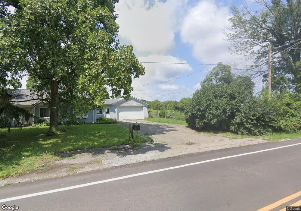
6711 State Route 503 S West Alexandria, OH 45381
Estimated Value: $286,000 - $405,217
3
Beds
2
Baths
2,030
Sq Ft
$169/Sq Ft
Est. Value
About This Home
This home is located at 6711 State Route 503 S, West Alexandria, OH 45381 and is currently estimated at $342,554, approximately $168 per square foot. 6711 State Route 503 S is a home located in Preble County with nearby schools including Preble Shawnee Elementary School, West Elkton Intermediate School, and Preble Shawnee Junior/Senior High School.
Ownership History
Date
Name
Owned For
Owner Type
Purchase Details
Closed on
May 14, 2001
Sold by
Napier William L
Bought by
Collins Paul R and Collins Lynn M
Current Estimated Value
Home Financials for this Owner
Home Financials are based on the most recent Mortgage that was taken out on this home.
Original Mortgage
$115,000
Outstanding Balance
$42,814
Interest Rate
6.99%
Mortgage Type
New Conventional
Estimated Equity
$299,740
Create a Home Valuation Report for This Property
The Home Valuation Report is an in-depth analysis detailing your home's value as well as a comparison with similar homes in the area
Home Values in the Area
Average Home Value in this Area
Purchase History
| Date | Buyer | Sale Price | Title Company |
|---|---|---|---|
| Collins Paul R | $145,000 | -- |
Source: Public Records
Mortgage History
| Date | Status | Borrower | Loan Amount |
|---|---|---|---|
| Open | Collins Paul R | $115,000 |
Source: Public Records
Tax History Compared to Growth
Tax History
| Year | Tax Paid | Tax Assessment Tax Assessment Total Assessment is a certain percentage of the fair market value that is determined by local assessors to be the total taxable value of land and additions on the property. | Land | Improvement |
|---|---|---|---|---|
| 2024 | $1,858 | $93,930 | $59,070 | $34,860 |
| 2023 | $1,955 | $93,930 | $59,070 | $34,860 |
| 2022 | $1,656 | $44,610 | $11,360 | $33,250 |
| 2021 | $1,704 | $81,290 | $48,040 | $33,250 |
| 2020 | $1,621 | $81,290 | $48,040 | $33,250 |
| 2019 | $1,573 | $77,530 | $45,750 | $31,780 |
| 2018 | $1,648 | $77,530 | $45,750 | $31,780 |
| 2017 | $1,531 | $77,530 | $45,750 | $31,780 |
| 2016 | $1,228 | $60,780 | $39,080 | $21,700 |
| 2014 | $1,963 | $60,830 | $39,130 | $21,700 |
| 2013 | $1,837 | $49,000 | $27,300 | $21,700 |
Source: Public Records
Map
Nearby Homes
- 205 Ada Doty St
- 3412 Ohio 122
- 11756 Ohio 122
- 8023 Pleasant Valley Rd
- 3292 Twin Creek Rd
- 10187 Quaker Trace Rd
- 14541 Lower Gratis Rd
- 4801 Fisher Twin Rd
- 9987 Puddenbag Rd
- 759 Barnetts Mill Rd
- 1020 Howard Ct
- 54 Apple Dr
- 15600 Dechant Rd
- 57 Apple Dr
- 1389 Leon Dr
- 3993 Farmersville W Alex Rd
- 3659 Winston Ln
- 40 E Washington St
- 287 S Broadway St
- 204 S Elm St
- 6655 State Route 503 S
- 400 Ada Doty St
- 405 N Ada Doty St
- 6586 State Route 503 S
- 403 N Ada Doty St
- 102 Indian Hill Dr
- 102 Indian Hill Rd
- 311 N Ada Doty St
- 104 Indian Hill Rd
- 104 Indian Hill Dr
- 205 Patrick Dr
- 413 Ada Doty St
- 105 Indian Hill Rd
- 105 Indian Hill Dr
- 204 Patrick Dr
- 106 Indian Hill Dr
- 6618 S St Rt 503
- 110 Indian Hill Dr
- 108 Indian Hill Dr
- 112 Indian Hill Dr