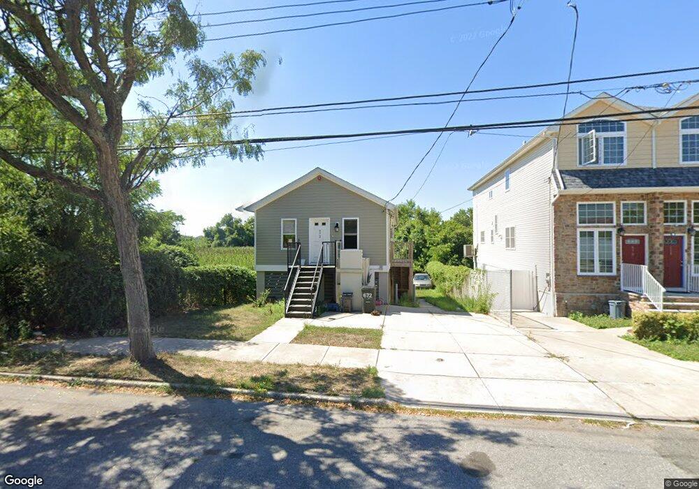
672 Seaview Ave Staten Island, NY 10305
Ocean Breeze NeighborhoodEstimated Value: $584,000 - $704,000
2
Beds
1
Bath
866
Sq Ft
$727/Sq Ft
Est. Value
About This Home
This home is located at 672 Seaview Ave, Staten Island, NY 10305 and is currently estimated at $629,732, approximately $727 per square foot. 672 Seaview Ave is a home located in Richmond County with nearby schools including P.S. 052 John C. Thompson, Is 2 George L Egbert, and New Dorp High School.
Ownership History
Date
Name
Owned For
Owner Type
Purchase Details
Closed on
Oct 31, 2006
Sold by
Petrai Louis
Bought by
Petrai John and Petrai Louanne
Current Estimated Value
Purchase Details
Closed on
Jul 18, 2000
Sold by
Petrai John
Bought by
Petrai Louis
Purchase Details
Closed on
Oct 7, 1998
Sold by
State Of New York Mtg Agency
Bought by
Petrai John
Home Financials for this Owner
Home Financials are based on the most recent Mortgage that was taken out on this home.
Original Mortgage
$37,000
Interest Rate
6.49%
Create a Home Valuation Report for This Property
The Home Valuation Report is an in-depth analysis detailing your home's value as well as a comparison with similar homes in the area
Home Values in the Area
Average Home Value in this Area
Purchase History
| Date | Buyer | Sale Price | Title Company |
|---|---|---|---|
| Petrai John | -- | None Available | |
| Petrai Louis | -- | United General Title Ins Co | |
| Petrai John | $48,000 | United General Title Ins Co |
Source: Public Records
Mortgage History
| Date | Status | Borrower | Loan Amount |
|---|---|---|---|
| Previous Owner | Petrai John | $37,000 |
Source: Public Records
Tax History Compared to Growth
Tax History
| Year | Tax Paid | Tax Assessment Tax Assessment Total Assessment is a certain percentage of the fair market value that is determined by local assessors to be the total taxable value of land and additions on the property. | Land | Improvement |
|---|---|---|---|---|
| 2025 | $3,843 | $37,020 | $3,945 | $33,075 |
| 2024 | $3,843 | $31,020 | $4,441 | $26,579 |
| 2023 | $3,666 | $18,052 | $3,754 | $14,298 |
| 2022 | $3,454 | $28,140 | $7,200 | $20,940 |
| 2021 | $3,641 | $23,280 | $7,200 | $16,080 |
| 2020 | $3,662 | $20,100 | $7,200 | $12,900 |
| 2019 | $3,452 | $17,460 | $7,200 | $10,260 |
| 2018 | $2,256 | $11,066 | $5,579 | $5,487 |
| 2017 | $2,128 | $10,440 | $7,200 | $3,240 |
| 2016 | $2,867 | $14,340 | $9,960 | $4,380 |
| 2015 | $2,521 | $13,906 | $7,496 | $6,410 |
| 2014 | $2,521 | $13,136 | $7,081 | $6,055 |
Source: Public Records
Map
Nearby Homes
- 0 Quincy Ave
- 000 Quincy Ave
- 762 Seaview Ave
- 602 Seaview Ave
- 431 Patterson Ave
- 795 Father Capodanno Blvd
- 797 Father Capodanno Blvd
- 521 Buel Ave
- 799 Father Capodanno Blvd
- 498 Dongan Hills Ave
- 517 Buel Ave
- 473 Dongan Hills Ave
- 467 Dongan Hills Ave
- 197 Slater Blvd
- 9 Iroquois St
- 00 Baden Place
- 0 Baden Place Unit 2503276
- 929 Father Capodanno Blvd
- 188 Graham Blvd Unit B
- 428 Cromwell Ave
- 670 Seaview Ave
- 668 Seaview Ave
- 666 Seaview Ave
- 664 Seaview Ave
- 662 Seaview Ave
- 660 Seaview Ave
- 658 Seaview Ave
- 664-731 Liberty Ave
- 662-731 Liberty Ave
- 656 Seaview Ave
- 662 Liberty Ave
- 664 Liberty Ave
- 694 Seaview Ave
- 660-735 Liberty Ave
- 654 Seaview Ave
- 658-727 Liberty Ave
- 563 Quincy Ave
- 660 Liberty Ave
- 567 Quincy Ave
- 652 Seaview Ave