C
Seller's Agent in 2012
Cindy Gregoire
Mark D Olejniczak Realty, Inc.
(920) 619-8733
20 Total Sales
Estimated Value: $432,283 - $486,000
Beautiful East De Pere subdivision adjacent to East River Parkway Conservancy Trail and access to East River Trail System. East De Pere Schools. Restrictive covenants. Open to all builders. No minimum square footage requirements.
Last Agent to Sell the Property
Mark D Olejniczak Realty, Inc. License #94-69748 Listed on: 02/14/2012
Last Buyer's Agent
Mark D Olejniczak Realty, Inc. License #94-69748 Listed on: 02/14/2012
Property Type
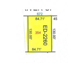
Lot Details
Location
Schools
Community Details
| Date | Buyer | Sale Price | Title Company |
|---|---|---|---|
| Yost Brien | $255,900 | None Available | |
| Donovan Brock A | $155,300 | None Available | |
| Tim Halbrook Builders Inc | $30,000 | Knight Barry Title |
| Date | Status | Borrower | Loan Amount |
|---|---|---|---|
| Open | Yost Brien | $228,000 | |
| Previous Owner | Donovan Brock A | $140,000 | |
| Previous Owner | Donovan Brock A | $147,000 | |
| Previous Owner | Tim Halbrook Builders Inc | $22,500 | |
| Previous Owner | Hillcrest Lumber Inc | $450,000 | |
| Previous Owner | Hillcrest Lumber Inc | $900,000 |
| Date | Event | Price | Change | Sq Ft Price |
|---|---|---|---|---|
| 03/31/2012 03/31/12 | Sold | $30,000 | 0.0% | -- |
| 03/07/2012 03/07/12 | Pending | -- | -- | -- |
| 02/14/2012 02/14/12 | For Sale | $30,000 | -- | -- |
| Year | Tax Paid | Tax Assessment Tax Assessment Total Assessment is a certain percentage of the fair market value that is determined by local assessors to be the total taxable value of land and additions on the property. | Land | Improvement |
|---|---|---|---|---|
| 2022 | $4,513 | $315,200 | $42,600 | $272,600 |
| 2021 | $4,334 | $286,600 | $35,500 | $251,100 |
| 2020 | $4,425 | $267,400 | $35,500 | $231,900 |
| 2019 | $4,626 | $255,900 | $35,500 | $220,400 |
| 2018 | $5,093 | $255,900 | $35,500 | $220,400 |
| 2017 | $3,476 | $171,400 | $35,500 | $135,900 |
| 2016 | $3,659 | $171,400 | $35,500 | $135,900 |
| 2015 | $3,355 | $155,300 | $31,200 | $124,100 |
| 2014 | $944 | $155,300 | $31,200 | $124,100 |
| 2013 | $944 | $155,300 | $31,200 | $124,100 |
C
Seller's Agent in 2012
Cindy Gregoire
Mark D Olejniczak Realty, Inc.
(920) 619-8733
20 Total Sales
Source: REALTORS® Association of Northeast Wisconsin
MLS Number: 50048916
APN: ED2260
Disclaimer: Certain information contained herein is derived from information provided by parties other than Homes.com. All information provided is deemed reliable, but is not guaranteed to be accurate and should be independently verified.
![]() Copyright REALTORS Association of Northeast Wisconsin MLS, Inc. - All Rights Reserved
Copyright REALTORS Association of Northeast Wisconsin MLS, Inc. - All Rights Reserved
Information received from other 3rd parties: All information deemed reliable but not guaranteed and should be independently verified. All properties are subject to prior sale, change, or withdrawal. Neither listing broker nor Ten-X nor RANW MLS shall be responsible for any typographical errors, misinformation, misprints, and shall be held totally harmless.
IDX information is provided exclusively for consumers’ personal, non-commercial use, that it may not be used for any purpose other than to identify prospective properties consumers may be interested in purchasing, and that the data is deemed reliable but is not guaranteed accurate by the MLS.
