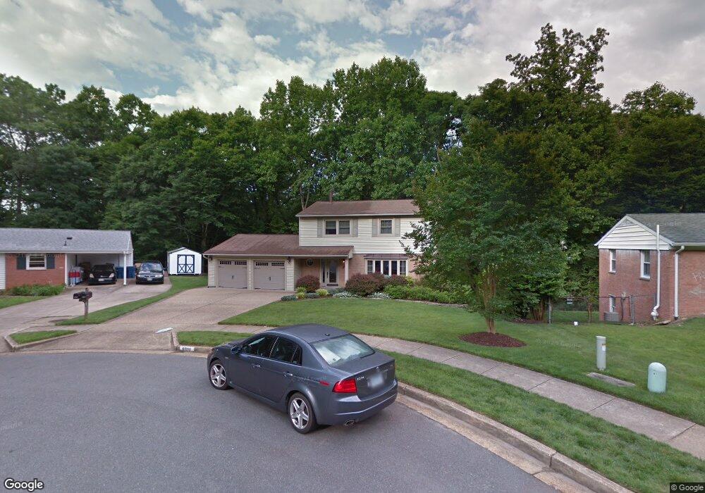
6720 Holford Ln Springfield, VA 22152
Estimated Value: $776,000 - $868,000
4
Beds
3
Baths
2,169
Sq Ft
$375/Sq Ft
Est. Value
About This Home
This home is located at 6720 Holford Ln, Springfield, VA 22152 and is currently estimated at $812,612, approximately $374 per square foot. 6720 Holford Ln is a home located in Fairfax County with nearby schools including Rolling Valley Elementary School, Irving Middle School, and West Springfield High School.
Ownership History
Date
Name
Owned For
Owner Type
Purchase Details
Closed on
Jul 26, 1995
Sold by
Long Gregory B
Bought by
Bursley J C
Current Estimated Value
Home Financials for this Owner
Home Financials are based on the most recent Mortgage that was taken out on this home.
Original Mortgage
$194,750
Interest Rate
7.56%
Create a Home Valuation Report for This Property
The Home Valuation Report is an in-depth analysis detailing your home's value as well as a comparison with similar homes in the area
Home Values in the Area
Average Home Value in this Area
Purchase History
| Date | Buyer | Sale Price | Title Company |
|---|---|---|---|
| Bursley J C | $205,000 | -- |
Source: Public Records
Mortgage History
| Date | Status | Borrower | Loan Amount |
|---|---|---|---|
| Closed | Bursley J C | $194,750 |
Source: Public Records
Tax History
| Year | Tax Paid | Tax Assessment Tax Assessment Total Assessment is a certain percentage of the fair market value that is determined by local assessors to be the total taxable value of land and additions on the property. | Land | Improvement |
|---|---|---|---|---|
| 2025 | $8,118 | $770,760 | $256,000 | $514,760 |
| 2024 | $8,118 | $700,760 | $226,000 | $474,760 |
| 2023 | $7,678 | $680,390 | $226,000 | $454,390 |
| 2022 | $7,339 | $641,790 | $216,000 | $425,790 |
| 2021 | $6,796 | $579,150 | $191,000 | $388,150 |
| 2020 | $6,732 | $568,820 | $186,000 | $382,820 |
| 2019 | $6,732 | $568,820 | $186,000 | $382,820 |
| 2018 | $6,293 | $547,220 | $186,000 | $361,220 |
| 2017 | $6,173 | $531,700 | $181,000 | $350,700 |
| 2016 | $5,802 | $500,860 | $171,000 | $329,860 |
Source: Public Records
Map
Nearby Homes
- 6708 Portree Ct
- 6600 Kensal Ct
- 8615 Kerry Ln
- 6526 Greenview Ln
- 7013 Galgate Dr
- 6809 Ontario St
- 8600 Kentford Dr
- 7006 Barnack Dr
- 8619 Nanlee Dr
- 6815 Rolling Rd
- 8703 Etta Dr
- 8120 Springfield Village Dr
- 0 Dryburgh Ct
- 8709 Powder Horn Rd
- 8118 Viola St
- 6410 Wyngate Dr
- 7229 Olde Lantern Way
- 8433 Millwood Dr
- 8705 Side Saddle Rd
- 8408 Millwood Dr
- 6718 Holford Ln
- 6722 Holford Ln
- 6716 Holford Ln
- 6724 Holford Ln
- 6714 Holford Ln
- 6721 Holford Ln
- 6723 Holford Ln
- 6717 Holford Ln
- 6712 Holford Ln
- 6715 Holford Ln
- 6719 Holford Ln
- 6713 Holford Ln
- 6711 Holford Ln
- 6712 Portree Ct
- 6710 Holford Ln
- 6711 Portree Ct
- 6715 Greenview Ln
- 6710 Portree Ct
- 6708 Holford Ln
- 6723 Greenview Ln
Your Personal Tour Guide
Ask me questions while you tour the home.