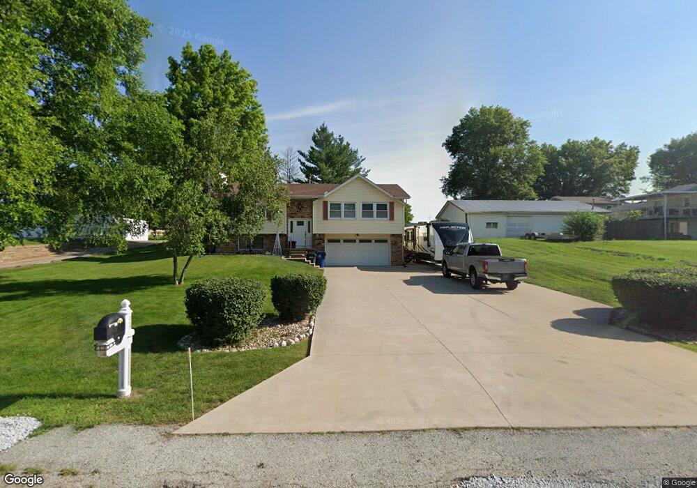
6726 W 9th St Davenport, IA 52804
Outer Davenport/Bettendorf NeighborhoodEstimated Value: $276,000 - $294,000
3
Beds
2
Baths
1,276
Sq Ft
$225/Sq Ft
Est. Value
About This Home
This home is located at 6726 W 9th St, Davenport, IA 52804 and is currently estimated at $287,128, approximately $225 per square foot. 6726 W 9th St is a home located in Scott County with nearby schools including Jackson Elementary School, Walcott Intermediate School, and West High School.
Ownership History
Date
Name
Owned For
Owner Type
Purchase Details
Closed on
Sep 24, 2010
Sold by
Remley Cody S and Remley Alicia
Bought by
Webb Michael A and Webb Becki L
Current Estimated Value
Home Financials for this Owner
Home Financials are based on the most recent Mortgage that was taken out on this home.
Original Mortgage
$142,086
Outstanding Balance
$93,729
Interest Rate
4.42%
Mortgage Type
FHA
Estimated Equity
$193,399
Purchase Details
Closed on
Nov 28, 2005
Sold by
Vrana Gordon and Vrana Judith M
Bought by
Remley Cody S
Home Financials for this Owner
Home Financials are based on the most recent Mortgage that was taken out on this home.
Original Mortgage
$138,009
Interest Rate
6.2%
Mortgage Type
FHA
Create a Home Valuation Report for This Property
The Home Valuation Report is an in-depth analysis detailing your home's value as well as a comparison with similar homes in the area
Home Values in the Area
Average Home Value in this Area
Purchase History
| Date | Buyer | Sale Price | Title Company |
|---|---|---|---|
| Webb Michael A | $144,000 | Gomez Title | |
| Remley Cody S | $139,500 | None Available |
Source: Public Records
Mortgage History
| Date | Status | Borrower | Loan Amount |
|---|---|---|---|
| Open | Webb Michael A | $142,086 | |
| Previous Owner | Remley Cody S | $138,009 |
Source: Public Records
Tax History Compared to Growth
Tax History
| Year | Tax Paid | Tax Assessment Tax Assessment Total Assessment is a certain percentage of the fair market value that is determined by local assessors to be the total taxable value of land and additions on the property. | Land | Improvement |
|---|---|---|---|---|
| 2025 | $3,730 | $250,290 | $54,500 | $195,790 |
| 2024 | $3,754 | $232,690 | $54,500 | $178,190 |
| 2023 | $3,882 | $232,690 | $54,500 | $178,190 |
| 2022 | $3,758 | $190,610 | $43,600 | $147,010 |
| 2021 | $3,758 | $184,050 | $43,600 | $140,450 |
| 2020 | $3,464 | $168,290 | $43,600 | $124,690 |
| 2019 | $3,584 | $168,290 | $43,600 | $124,690 |
| 2018 | $3,360 | $168,290 | $43,600 | $124,690 |
| 2017 | $3,484 | $161,730 | $43,600 | $118,130 |
| 2016 | $3,264 | $157,760 | $0 | $0 |
| 2015 | $3,264 | $151,940 | $0 | $0 |
| 2014 | $3,182 | $151,940 | $0 | $0 |
| 2013 | $3,122 | $0 | $0 | $0 |
| 2012 | -- | $142,720 | $41,100 | $101,620 |
Source: Public Records
Map
Nearby Homes