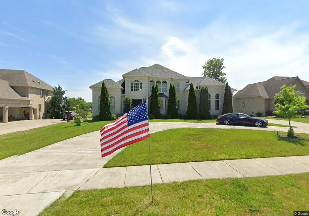
6747 Langston Run Canfield, OH 44406
Estimated Value: $603,000 - $976,000
3
Beds
3
Baths
2,599
Sq Ft
$284/Sq Ft
Est. Value
About This Home
This home is located at 6747 Langston Run, Canfield, OH 44406 and is currently estimated at $737,099, approximately $283 per square foot. 6747 Langston Run is a home located in Mahoning County with nearby schools including Canfield Village Middle School, Canfield High School, and St Charles Elementary School.
Ownership History
Date
Name
Owned For
Owner Type
Purchase Details
Closed on
Jan 19, 2007
Sold by
C T W Development Corp
Bought by
Coury John
Current Estimated Value
Home Financials for this Owner
Home Financials are based on the most recent Mortgage that was taken out on this home.
Original Mortgage
$63,750
Interest Rate
6.16%
Mortgage Type
Purchase Money Mortgage
Create a Home Valuation Report for This Property
The Home Valuation Report is an in-depth analysis detailing your home's value as well as a comparison with similar homes in the area
Home Values in the Area
Average Home Value in this Area
Purchase History
| Date | Buyer | Sale Price | Title Company |
|---|---|---|---|
| Coury John | $85,000 | Attorney |
Source: Public Records
Mortgage History
| Date | Status | Borrower | Loan Amount |
|---|---|---|---|
| Closed | Coury John | $63,750 |
Source: Public Records
Tax History Compared to Growth
Tax History
| Year | Tax Paid | Tax Assessment Tax Assessment Total Assessment is a certain percentage of the fair market value that is determined by local assessors to be the total taxable value of land and additions on the property. | Land | Improvement |
|---|---|---|---|---|
| 2024 | $7,947 | $191,740 | $49,000 | $142,740 |
| 2023 | $7,978 | $191,740 | $49,000 | $142,740 |
| 2022 | $8,140 | $159,600 | $29,750 | $129,850 |
| 2021 | $8,216 | $159,600 | $29,750 | $129,850 |
| 2020 | $8,118 | $159,600 | $29,750 | $129,850 |
| 2019 | $7,797 | $137,060 | $29,750 | $107,310 |
| 2018 | $7,567 | $137,060 | $29,750 | $107,310 |
| 2017 | $7,464 | $137,060 | $29,750 | $107,310 |
| 2016 | $6,622 | $117,350 | $27,300 | $90,050 |
| 2015 | $6,479 | $117,350 | $27,300 | $90,050 |
| 2014 | $6,671 | $117,350 | $27,300 | $90,050 |
| 2013 | $6,279 | $117,350 | $27,300 | $90,050 |
Source: Public Records
Map
Nearby Homes
- 6845 Abbey Rd
- 6843 Abbey Rd
- 6837 Abbey Rd S
- 6839 Abbey Rd S
- 4300 Westford Place Unit 13D
- 5034 Macy Ln
- 6850 Abbey Rd N
- 5025 Macy Ln
- 6670 Summit Dr
- 6645 Summit Dr
- 7245 Hanbury Close
- 4032 Saint Andrews Ct Unit 1
- 6857 Kyle Ridge Pointe
- 6879 Kyle Ridge Pointe
- 6836 Twin Oaks Ct
- 6957 Tippecanoe Rd
- 6911 Tippecanoe Rd
- 6729 Tippecanoe Rd Unit 6
- 473 Carriage Hill Dr
- 100 Talsman Dr
- 6755 Langston Run
- 6739 Langston Run
- 6763 Langston Run
- 6731 Langston Run
- 6738 Langston Run
- 6746 Langston Run
- 6754 Langston Run
- 6730 Langston Run
- 6771 Langston Run
- 6723 Langston Run
- 6722 Langston Run
- 6762 Langston Run
- 6770 Langston Run
- 6714 Langston Run
- 6971 Summit Dr
- 6951 Summit Dr
- 6993 Summit Dr
- 6931 Summit Dr
- 7025 Summit Dr
- 6786 Langston Run