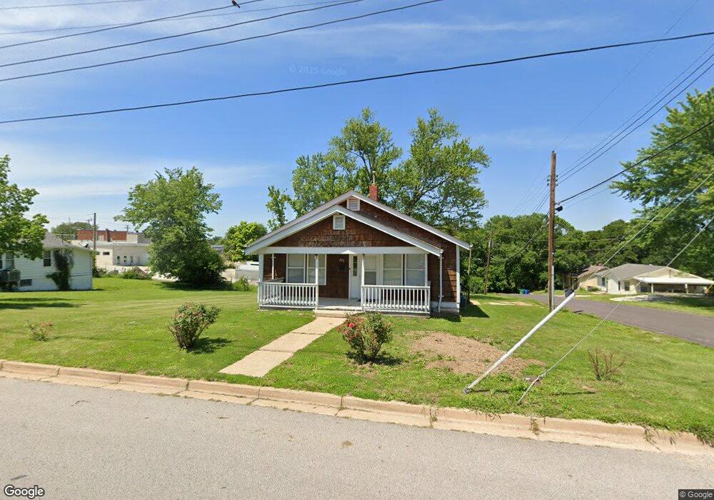
675 Ridge Ave Saint Clair, MO 63077
Estimated Value: $143,614 - $145,000
2
Beds
1
Bath
992
Sq Ft
$145/Sq Ft
Est. Value
About This Home
This home is located at 675 Ridge Ave, Saint Clair, MO 63077 and is currently estimated at $144,307, approximately $145 per square foot. 675 Ridge Ave is a home located in Franklin County with nearby schools including St. Clair Elementary School, Edgar Murray Elementary School, and St. Clair Junior High School.
Ownership History
Date
Name
Owned For
Owner Type
Purchase Details
Closed on
Jun 23, 2014
Sold by
Shea Timothy R
Bought by
Franklin Financial Corp
Current Estimated Value
Purchase Details
Closed on
Jun 19, 2014
Sold by
Shea Thomas Welch and Shea Laura Elizabeth
Bought by
Shea Timothy R
Purchase Details
Closed on
Jun 13, 2014
Sold by
Shea Todd
Bought by
Shea Timothy R
Purchase Details
Closed on
Mar 28, 2007
Sold by
Edwards Neil and Edwards Mark K
Bought by
County Of Franklin And State Of Missouri
Home Financials for this Owner
Home Financials are based on the most recent Mortgage that was taken out on this home.
Original Mortgage
$30,000
Interest Rate
6.19%
Mortgage Type
New Conventional
Create a Home Valuation Report for This Property
The Home Valuation Report is an in-depth analysis detailing your home's value as well as a comparison with similar homes in the area
Home Values in the Area
Average Home Value in this Area
Purchase History
| Date | Buyer | Sale Price | Title Company |
|---|---|---|---|
| Franklin Financial Corp | $35,000 | -- | |
| Shea Timothy R | -- | -- | |
| Shea Timothy R | -- | -- | |
| County Of Franklin And State Of Missouri | -- | None Available |
Source: Public Records
Mortgage History
| Date | Status | Borrower | Loan Amount |
|---|---|---|---|
| Previous Owner | County Of Franklin And State Of Missouri | $30,000 |
Source: Public Records
Tax History
| Year | Tax Paid | Tax Assessment Tax Assessment Total Assessment is a certain percentage of the fair market value that is determined by local assessors to be the total taxable value of land and additions on the property. | Land | Improvement |
|---|---|---|---|---|
| 2025 | $1,000 | $14,843 | $0 | $0 |
| 2024 | $1,000 | $13,564 | $0 | $0 |
| 2023 | $832 | $13,564 | $0 | $0 |
| 2022 | $755 | $12,247 | $0 | $0 |
| 2021 | $754 | $12,247 | $0 | $0 |
| 2020 | $699 | $10,900 | $0 | $0 |
| 2019 | $694 | $10,900 | $0 | $0 |
| 2018 | $695 | $10,786 | $0 | $0 |
| 2017 | $694 | $10,786 | $0 | $0 |
| 2016 | $720 | $11,176 | $0 | $0 |
| 2015 | $667 | $11,176 | $0 | $0 |
| 2014 | $675 | $11,315 | $0 | $0 |
Source: Public Records
Map
Nearby Homes
- 325 Iris Ct
- 830 Walton St
- 235 E Oak St
- 330 Young St
- 45 E Oak St
- 605 N Main St
- 208 Mosley Ave
- 5 Lots Mosley Ave
- 315 W Oak St
- 390 Highway Dr
- 347 Roller Rd
- 1322 Casey Ave
- 909 Q Ave
- 0 Crescent Lake Rd Unit MIS25079528
- 322 Cart Path Ln
- 0 Oak Ridge Dr Unit MIS25078521
- 555 Mulligan Ct
- 0 Gravois Rd Unit 11555468
- 614 T-Box Dr
- 1638 Neff Rd
- 715 Ridge Ave
- 655 Ridge Ave
- 320 Nashville St
- 725 Ridge Ave
- 310 Nashville St
- 710 Ridge Ave
- 720 Ridge Ave
- 745 Ridge Ave
- 710 Maupin St
- 730 Ridge Ave
- 716 Maupin St
- 750 Ridge Ave
- 720 Maupin St
- 765 Ridge Ave
- 760 Ridge Ave
- 795 Maupin St
- 170 S Frisco St Unit 1
- 365 S Main St Unit 1
- 365 S Main St
- 465 S Main St
Your Personal Tour Guide
Ask me questions while you tour the home.