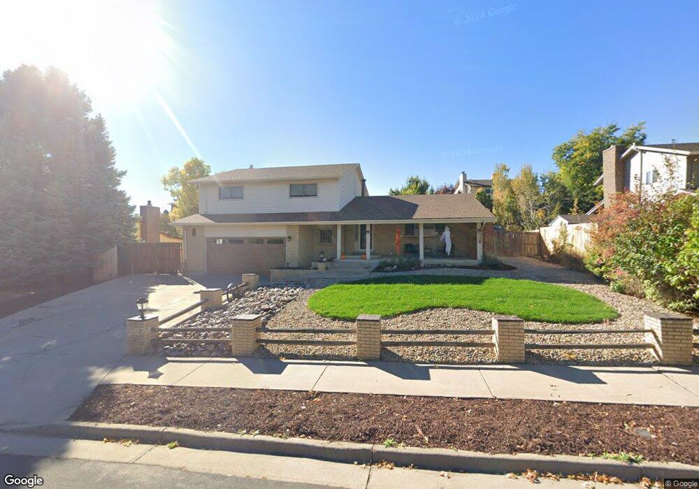
676 Altair Dr Lone Tree, CO 80124
Estimated Value: $573,000 - $609,291
3
Beds
3
Baths
2,735
Sq Ft
$215/Sq Ft
Est. Value
About This Home
This home is located at 676 Altair Dr, Lone Tree, CO 80124 and is currently estimated at $589,073, approximately $215 per square foot. 676 Altair Dr is a home located in Douglas County with nearby schools including Acres Green Elementary School, Cresthill Middle School, and Highlands Ranch High School.
Ownership History
Date
Name
Owned For
Owner Type
Purchase Details
Closed on
Dec 9, 2021
Sold by
Laurene Leaman Trust
Bought by
Torres Christopher J
Current Estimated Value
Home Financials for this Owner
Home Financials are based on the most recent Mortgage that was taken out on this home.
Original Mortgage
$477,000
Outstanding Balance
$438,891
Interest Rate
3.14%
Mortgage Type
New Conventional
Estimated Equity
$150,182
Purchase Details
Closed on
Sep 15, 2010
Sold by
Laurene Leaman Trust
Bought by
Valtakis Laurene Marie
Purchase Details
Closed on
Dec 20, 1995
Sold by
Leaman Lila L and Leaman Laurene
Bought by
The Laurene Leaman Trust
Purchase Details
Closed on
Aug 26, 1994
Sold by
Myers Charles Eugene and Myers Beverly A
Bought by
Leaman Lila L
Purchase Details
Closed on
Sep 27, 1976
Sold by
Morris General Contractors Inc
Bought by
Myers Charles Eugene and Myers Beverly A
Create a Home Valuation Report for This Property
The Home Valuation Report is an in-depth analysis detailing your home's value as well as a comparison with similar homes in the area
Home Values in the Area
Average Home Value in this Area
Purchase History
| Date | Buyer | Sale Price | Title Company |
|---|---|---|---|
| Torres Christopher J | $530,000 | Land Title Guarantee Company | |
| Valtakis Laurene Marie | -- | None Available | |
| The Laurene Leaman Trust | -- | -- | |
| Leaman Lila L | $150,000 | -- | |
| Myers Charles Eugene | $50,700 | -- |
Source: Public Records
Mortgage History
| Date | Status | Borrower | Loan Amount |
|---|---|---|---|
| Open | Torres Christopher J | $477,000 |
Source: Public Records
Tax History Compared to Growth
Tax History
| Year | Tax Paid | Tax Assessment Tax Assessment Total Assessment is a certain percentage of the fair market value that is determined by local assessors to be the total taxable value of land and additions on the property. | Land | Improvement |
|---|---|---|---|---|
| 2024 | $3,241 | $39,000 | $8,190 | $30,810 |
| 2023 | $3,274 | $39,000 | $8,190 | $30,810 |
| 2022 | $2,604 | $29,240 | $6,950 | $22,290 |
| 2021 | $2,708 | $29,240 | $6,950 | $22,290 |
| 2020 | $2,592 | $28,680 | $6,580 | $22,100 |
| 2019 | $2,601 | $28,680 | $6,580 | $22,100 |
| 2018 | $2,092 | $24,710 | $5,720 | $18,990 |
| 2017 | $2,127 | $24,710 | $5,720 | $18,990 |
| 2016 | $1,900 | $21,620 | $4,150 | $17,470 |
| 2015 | $971 | $21,620 | $4,150 | $17,470 |
| 2014 | $872 | $18,170 | $3,980 | $14,190 |
Source: Public Records
Map
Nearby Homes
- 802 Altair Dr
- 789 Hamal Dr
- 13134 Deneb Dr
- 13117 Deneb Dr
- 7057 Chestnut Hill St
- 13483 Achilles Dr
- 13542 Achilles Dr
- 8159 Lodgepole Trail
- 181 Dianna Dr
- 7041 Chestnut Hill Trail
- 130 Dianna Dr
- 108 Olympus Cir
- 6887 Chestnut Hill St
- 9275 Erminedale Dr
- 9308 Miles Dr Unit 5
- 9412 La Quinta Way
- 7920 E Phillips Cir
- 8860 Kachina Way
- 8822 Fiesta Terrace
- 6482 Silver Mesa Dr Unit B