Estimated Value: $364,893 - $444,000
4
Beds
2
Baths
2,256
Sq Ft
$187/Sq Ft
Est. Value
About This Home
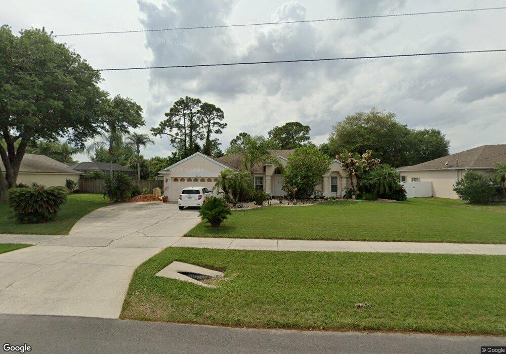
This home is located at 6766 Opal Ave, Cocoa, FL 32927 and is currently estimated at $422,473, approximately $187 per square foot. 6766 Opal Ave is a home located in Brevard County with nearby schools including Atlantis Elementary School, Space Coast Junior/Senior High School, and Sculptor Charter School.
Ownership History
Date
Name
Owned For
Owner Type
Purchase Details
Closed on
Jan 28, 1999
Sold by
Mercedes Homes Inc
Bought by
Medina Patrick J and Medina Korina R
Current Estimated Value
Home Financials for this Owner
Home Financials are based on the most recent Mortgage that was taken out on this home.
Original Mortgage
$94,150
Outstanding Balance
$22,246
Interest Rate
6.72%
Estimated Equity
$400,227
Purchase Details
Closed on
Sep 11, 1998
Sold by
Benson Jeanne A
Bought by
Mercedes Homes Inc
Create a Home Valuation Report for This Property
The Home Valuation Report is an in-depth analysis detailing your home's value as well as a comparison with similar homes in the area
Home Values in the Area
Average Home Value in this Area
Purchase History
| Date | Buyer | Sale Price | Title Company |
|---|---|---|---|
| Medina Patrick J | $118,600 | -- | |
| Mercedes Homes Inc | $14,500 | -- |
Source: Public Records
Mortgage History
| Date | Status | Borrower | Loan Amount |
|---|---|---|---|
| Open | Medina Patrick J | $94,150 |
Source: Public Records
Tax History
| Year | Tax Paid | Tax Assessment Tax Assessment Total Assessment is a certain percentage of the fair market value that is determined by local assessors to be the total taxable value of land and additions on the property. | Land | Improvement |
|---|---|---|---|---|
| 2025 | $1,987 | $139,720 | -- | -- |
| 2024 | $1,944 | $135,790 | -- | -- |
| 2023 | $1,944 | $131,840 | $0 | $0 |
| 2022 | $1,820 | $128,000 | $0 | $0 |
| 2021 | $1,832 | $124,280 | $0 | $0 |
| 2020 | $1,745 | $122,570 | $0 | $0 |
| 2019 | $1,683 | $119,820 | $0 | $0 |
| 2018 | $1,678 | $117,590 | $0 | $0 |
| 2017 | $1,675 | $115,180 | $0 | $0 |
| 2016 | $1,686 | $112,820 | $29,000 | $83,820 |
| 2015 | $1,717 | $112,040 | $29,000 | $83,040 |
| 2014 | $1,722 | $111,160 | $29,000 | $82,160 |
Source: Public Records
Map
Nearby Homes
- 4824 Curtis Blvd
- 4760 Ivan St
- 4790 Greenhill St
- 4852 Alfred St
- 6820 Caliph Ave
- 0000 Unknown St
- 6990 Camden Ave
- 6620 Grissom Pkwy
- 4688 Fairsun St
- 5095 Hogan Place
- 4625 Curtis Blvd
- 6499 Pleasant Ave
- 0000 Grissom Pkwy
- 5080 Mayflower St
- 7155 Export Ave
- 6947 Carlowe Ave
- 5155 Mayflower St
- 5200 Frisco St
- 5165 Patricia St
- 7245 Grissom Pkwy
- 6772 Opal Ave
- 6760 Opal Ave
- 6781 Calusa Ave
- 6767 Opal Ave
- 6778 Opal Ave
- 6754 Opal Ave
- 6789 Calusa Ave
- 6761 Opal Ave
- 6773 Opal Ave
- 4865 Curtis Blvd
- 6779 Opal Ave
- 6775 Calusa Ave
- 6795 Calusa Ave
- 6748 Opal Ave
- 4845 Curtis Blvd
- 6846 Hartford Rd
- 6838 Hartford Rd
- 6780 E Calusa
- 6780 Calusa Ave
- 6749 Opal Ave
Your Personal Tour Guide
Ask me questions while you tour the home.