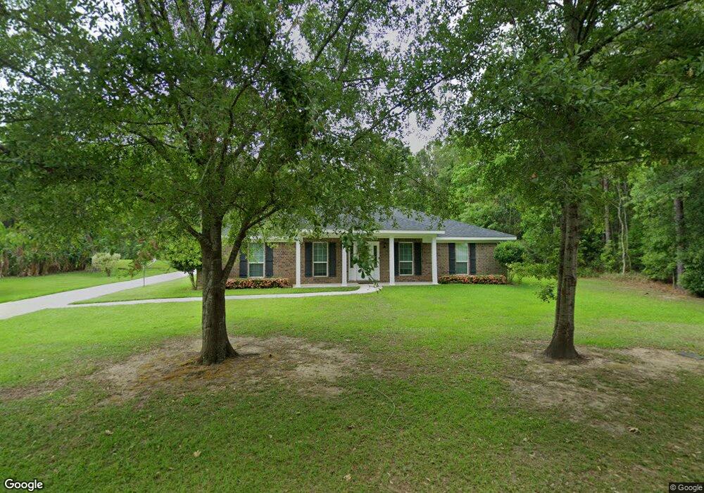
6775 Browder Dr Unit 19 Theodore, AL 36582
Westfield NeighborhoodEstimated Value: $229,784 - $263,000
--
Bed
--
Bath
1,760
Sq Ft
$139/Sq Ft
Est. Value
About This Home
This home is located at 6775 Browder Dr Unit 19, Theodore, AL 36582 and is currently estimated at $244,196, approximately $138 per square foot. 6775 Browder Dr Unit 19 is a home located in Mobile County with nearby schools including Nan Gray Davis Elementary School, Katherine H Hankins Middle School, and Theodore High School.
Ownership History
Date
Name
Owned For
Owner Type
Purchase Details
Closed on
Aug 23, 2017
Sold by
S S Steele & Co Inc
Bought by
Mclaughlin Brandi M
Current Estimated Value
Home Financials for this Owner
Home Financials are based on the most recent Mortgage that was taken out on this home.
Original Mortgage
$173,000
Outstanding Balance
$144,627
Interest Rate
4.03%
Mortgage Type
VA
Estimated Equity
$99,569
Purchase Details
Closed on
Sep 30, 2016
Sold by
Kyser John A and Kyser Gladys M
Bought by
S S Steele & Co Inc
Purchase Details
Closed on
Nov 20, 2015
Sold by
Laskay Terra Forwood and Theodore Development Co Inc
Bought by
Kyser John A and Kyser Gladys M
Create a Home Valuation Report for This Property
The Home Valuation Report is an in-depth analysis detailing your home's value as well as a comparison with similar homes in the area
Home Values in the Area
Average Home Value in this Area
Purchase History
| Date | Buyer | Sale Price | Title Company |
|---|---|---|---|
| Mclaughlin Brandi M | $173,000 | None Available | |
| S S Steele & Co Inc | $23,100 | None Available | |
| Kyser John A | $16,000 | None Available |
Source: Public Records
Mortgage History
| Date | Status | Borrower | Loan Amount |
|---|---|---|---|
| Open | Mclaughlin Brandi M | $173,000 |
Source: Public Records
Tax History Compared to Growth
Tax History
| Year | Tax Paid | Tax Assessment Tax Assessment Total Assessment is a certain percentage of the fair market value that is determined by local assessors to be the total taxable value of land and additions on the property. | Land | Improvement |
|---|---|---|---|---|
| 2024 | $990 | $18,050 | $2,200 | $15,850 |
| 2023 | $929 | $18,000 | $2,400 | $15,600 |
| 2022 | $795 | $17,770 | $2,000 | $15,770 |
| 2021 | $668 | $15,160 | $2,000 | $13,160 |
| 2020 | $707 | $15,940 | $2,250 | $13,690 |
| 2019 | $735 | $16,540 | $0 | $0 |
| 2018 | $742 | $16,680 | $0 | $0 |
| 2017 | $676 | $13,940 | $0 | $0 |
| 2016 | $213 | $4,400 | $0 | $0 |
| 2013 | $194 | $4,000 | $0 | $0 |
Source: Public Records
Map
Nearby Homes
- 6795 Browder Dr
- 6840 Highmont Dr
- 6799 Foxwood Dr
- 6631 Sandra Dr
- 6521 Barnes Rd
- 6624 Morgan Jackson Ct
- 6293 Woodside Dr S
- 6551 Tung Ave W
- 7432 Havenwood Dr
- 6913 Gray Oaks Dr
- 7520 Oak Dr W
- 6987 Magnolia Trace
- 6425 Boykin Rd
- 6178 Sperry Rd
- 6780 Boykin Rd
- 7340 Broadview Dr E
- 6008 Highway 90
- 7347 Broadview Dr E
- 6361 Rester Rd
- 0 Rester Rd
- 6775 Browder Dr
- 6761 Browder Dr
- 6792 Austin Ave Unit 1
- 6792 Austin Ave
- 6815 Browder Dr
- 6797 Austin Ave
- 6825 Browder Dr
- 6770 Browder Dr
- 6741 Browder Dr
- 6795 Austin Ave
- 0 Austin Ave Unit 623514
- 0 Austin Ave Unit 641636
- 0 Austin Ave Unit 5 0607332
- 0 Austin Ave Unit 5 0529269
- 0 Austin Ave
- 6812 Austin Ave
- 6760 Browder Dr
- 6810 Browder Dr
- 6810 Browder Dr Unit 7
- 6835 Browder Dr