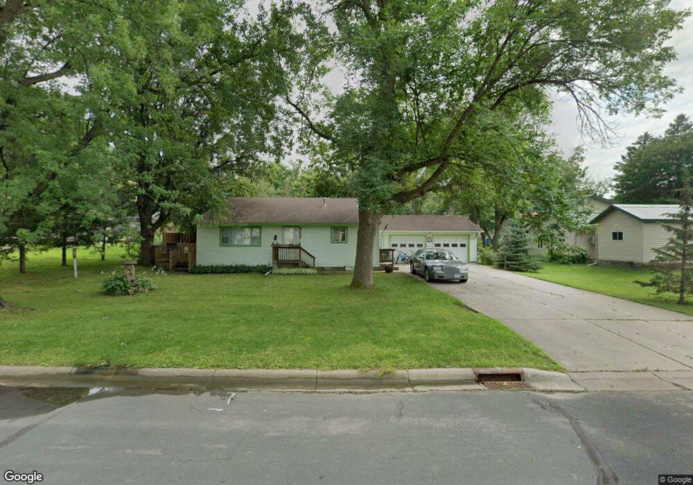
6780 Maple Dr Rockford, MN 55373
Estimated Value: $292,000 - $302,000
3
Beds
2
Baths
1,458
Sq Ft
$204/Sq Ft
Est. Value
About This Home
This home is located at 6780 Maple Dr, Rockford, MN 55373 and is currently estimated at $297,577, approximately $204 per square foot. 6780 Maple Dr is a home located in Wright County with nearby schools including Rockford Elementary Arts Magnet School, Rockford Middle School - Center for Environmental Studies, and Rockford High School.
Ownership History
Date
Name
Owned For
Owner Type
Purchase Details
Closed on
Oct 18, 2021
Sold by
Siers Eleanora M
Bought by
Franzen Brian G
Current Estimated Value
Home Financials for this Owner
Home Financials are based on the most recent Mortgage that was taken out on this home.
Original Mortgage
$218,500
Outstanding Balance
$199,482
Interest Rate
2.88%
Mortgage Type
New Conventional
Estimated Equity
$98,095
Create a Home Valuation Report for This Property
The Home Valuation Report is an in-depth analysis detailing your home's value as well as a comparison with similar homes in the area
Home Values in the Area
Average Home Value in this Area
Purchase History
| Date | Buyer | Sale Price | Title Company |
|---|---|---|---|
| Franzen Brian G | $230,000 | Executive Title Taylor |
Source: Public Records
Mortgage History
| Date | Status | Borrower | Loan Amount |
|---|---|---|---|
| Open | Franzen Brian G | $218,500 |
Source: Public Records
Tax History Compared to Growth
Tax History
| Year | Tax Paid | Tax Assessment Tax Assessment Total Assessment is a certain percentage of the fair market value that is determined by local assessors to be the total taxable value of land and additions on the property. | Land | Improvement |
|---|---|---|---|---|
| 2025 | $3,140 | $290,300 | $85,000 | $205,300 |
| 2024 | $3,030 | $284,100 | $85,000 | $199,100 |
| 2023 | $3,032 | $278,900 | $85,000 | $193,900 |
| 2022 | $2,920 | $252,300 | $70,000 | $182,300 |
| 2021 | $3,694 | $219,700 | $65,000 | $154,700 |
| 2020 | $3,188 | $211,600 | $65,000 | $146,600 |
| 2019 | $3,006 | $167,900 | $0 | $0 |
| 2018 | $2,780 | $126,900 | $0 | $0 |
| 2017 | $2,664 | $120,500 | $0 | $0 |
| 2016 | $2,906 | $0 | $0 | $0 |
| 2015 | $1,616 | $0 | $0 | $0 |
| 2014 | -- | $0 | $0 | $0 |
Source: Public Records
Map
Nearby Homes
- 6601 Elmwood Dr
- 6761 Maple Dr
- 6630 Maple Dr
- 7040 Winfield Rd
- 6911 Country Ln
- 6150 Boulder Ridge Dr
- 6101 Boulder Ridge Dr
- 4040 Maple Hurst Dr S
- 4090 Maple Hurst Dr S
- 2008 Little Creek Cir
- 8041 Prairie Trail
- 8130 Ravenrock Rd
- 4231 Maple Hurst Dr N
- 5741 Maple St
- 5523 Basswood Cir
- 8180 Ravenrock Rd
- 8907 Foust Ln
- 5311 Greenwood Ln
- 3439 Hall Ave SE
- 4829 Maple St
- 6651 Elmwood Dr
- 6650 Oakwood St
- 6641 Elmwood Dr
- 6640 Oakwood St
- 6640 6640 Oakwood St
- 6781 Maple Dr
- 6771 Maple Dr
- 6631 Elmwood Dr
- 6631 6631 Elmwood-Drive-
- 6630 Oakwood St
- 6630 6630 Oakwood St
- 6751 Maple Dr
- 6641 Oakwood St
- 6651 Oakwood St
- 6640 6640 Winfield Cir N
- 6640 Winfield Cir N
- 6621 Elmwood Dr
- 6650 Winfield Cir N
- 6631 Oakwood St
- 6620 6620 Oakwood St