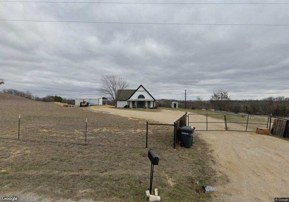
679 Sanger Dr Springtown, TX 76082
Estimated Value: $371,273 - $398,000
3
Beds
2
Baths
1,540
Sq Ft
$250/Sq Ft
Est. Value
About This Home
This home is located at 679 Sanger Dr, Springtown, TX 76082 and is currently estimated at $384,637, approximately $249 per square foot. 679 Sanger Dr is a home located in Parker County with nearby schools including Seguin Elementary School, Tison Middle School, and Weatherford High School.
Ownership History
Date
Name
Owned For
Owner Type
Purchase Details
Closed on
Sep 25, 2020
Sold by
Robert Robertson
Bought by
Garcia Zenaido
Current Estimated Value
Home Financials for this Owner
Home Financials are based on the most recent Mortgage that was taken out on this home.
Original Mortgage
$256,703
Outstanding Balance
$227,289
Interest Rate
2.9%
Mortgage Type
New Conventional
Estimated Equity
$157,348
Purchase Details
Closed on
Jun 22, 2018
Sold by
Howes Cody W and Howes Tyra
Bought by
Garcia Zenaido
Home Financials for this Owner
Home Financials are based on the most recent Mortgage that was taken out on this home.
Original Mortgage
$242,755
Interest Rate
4.5%
Mortgage Type
VA
Purchase Details
Closed on
Oct 8, 2013
Sold by
Crow Lisa A
Bought by
Howes Cody W and Howes Tyra
Home Financials for this Owner
Home Financials are based on the most recent Mortgage that was taken out on this home.
Original Mortgage
$116,844
Interest Rate
4.54%
Mortgage Type
FHA
Purchase Details
Closed on
Jul 23, 2010
Bought by
Howes Cody W and Howes Tyra
Home Financials for this Owner
Home Financials are based on the most recent Mortgage that was taken out on this home.
Original Mortgage
$99,890
Interest Rate
4.76%
Mortgage Type
New Conventional
Purchase Details
Closed on
Jun 14, 2010
Sold by
Hsbc Mortgage Services Inc
Bought by
Howes Cody W and Howes Tyra
Home Financials for this Owner
Home Financials are based on the most recent Mortgage that was taken out on this home.
Original Mortgage
$99,890
Interest Rate
4.76%
Mortgage Type
New Conventional
Purchase Details
Closed on
Aug 4, 2009
Sold by
Johnnie Anthony and Weeks Ann
Bought by
Howes Cody W and Howes Tyra
Purchase Details
Closed on
May 26, 2006
Sold by
Farmer Shane O
Bought by
Howes Cody W and Howes Tyra
Home Financials for this Owner
Home Financials are based on the most recent Mortgage that was taken out on this home.
Original Mortgage
$119,000
Interest Rate
6.5%
Mortgage Type
New Conventional
Purchase Details
Closed on
Apr 21, 2001
Sold by
Bryant Family Limited Partners
Bought by
Howes Cody W and Howes Tyra
Create a Home Valuation Report for This Property
The Home Valuation Report is an in-depth analysis detailing your home's value as well as a comparison with similar homes in the area
Home Values in the Area
Average Home Value in this Area
Purchase History
| Date | Buyer | Sale Price | Title Company |
|---|---|---|---|
| Garcia Zenaido | $251,568 | Davis Jeffry R | |
| Garcia Zenaido | -- | None Available | |
| Howes Cody W | -- | Providence Title | |
| Howes Cody W | -- | -- | |
| Howes Cody W | -- | -- | |
| Crow Lisa A | -- | Lsi Title Agency Inc | |
| Howes Cody W | -- | -- | |
| Hsbc Mortgage Services Inc | $111,297 | None Available | |
| Howes Cody W | -- | -- | |
| Ann Johnnie Anthony | -- | Alamo | |
| Howes Cody W | -- | -- |
Source: Public Records
Mortgage History
| Date | Status | Borrower | Loan Amount |
|---|---|---|---|
| Open | Garcia Zenaido | $256,703 | |
| Previous Owner | Garcia Zenaido | $242,755 | |
| Previous Owner | Howes Cody W | $116,844 | |
| Previous Owner | Crow Lisa A | $99,890 | |
| Previous Owner | Ann Johnnie Anthony | $119,000 |
Source: Public Records
Tax History Compared to Growth
Tax History
| Year | Tax Paid | Tax Assessment Tax Assessment Total Assessment is a certain percentage of the fair market value that is determined by local assessors to be the total taxable value of land and additions on the property. | Land | Improvement |
|---|---|---|---|---|
| 2025 | $1,740 | $264,869 | -- | -- |
| 2024 | $1,740 | $240,790 | $75,000 | $165,790 |
| 2023 | $1,740 | $227,120 | $0 | $0 |
| 2022 | $3,844 | $206,480 | $49,990 | $156,490 |
| 2021 | $4,159 | $206,480 | $49,990 | $156,490 |
| 2020 | $4,792 | $236,260 | $96,390 | $139,870 |
| 2019 | $5,112 | $236,260 | $96,390 | $139,870 |
| 2018 | $2,713 | $124,740 | $45,850 | $78,890 |
| 2017 | $2,769 | $124,740 | $45,850 | $78,890 |
| 2016 | $2,589 | $116,620 | $45,850 | $70,770 |
| 2015 | $2,544 | $116,620 | $45,850 | $70,770 |
| 2014 | $2,614 | $123,020 | $60,890 | $62,130 |
Source: Public Records
Map
Nearby Homes
- 340 Sanger Dr
- 650 Sanger Dr
- 105 Kathy Stephens Ave
- 408 Herb Stephens Jr Way
- F1201 Sanger Dr
- Lot 32 Colt Rd
- Lot 39 Colt Rd
- Lot 20 Colt Rd
- Lot 46 Colt Rd
- Lot 44 Colt Rd
- Lot 47 Colt Rd
- Lot 45 Colt Rd
- Lot 33 Colt Rd
- Lot 30 Colt Rd
- Lot 34 Colt Rd
- Lot 35 Colt Rd
- Lot 16 Colt Rd
- Lot 42 Colt Rd
- Lot 31 Colt Rd
- Lot 25 Colt Rd
- 670 Sanger Dr
- 655 Sanger Dr
- 680 Sanger Dr
- 755 Sanger Dr
- 630 Sanger Dr
- 611 Sanger Dr
- 801 Sanger Dr
- 610 Sanger Dr
- 691 Sanger Dr
- 851 Sanger Dr
- 216 Marshall Dr
- 550 Sanger Dr
- 348 Sanger Dr
- 421 Herb Stevens Jr
- 703 Sanger Dr
- 204 Marshall Dr
- 200 Marshall Dr
- 432 Herd Stephens Way
- 344 Sanger Dr
- 110 Kathy Stephens Ave