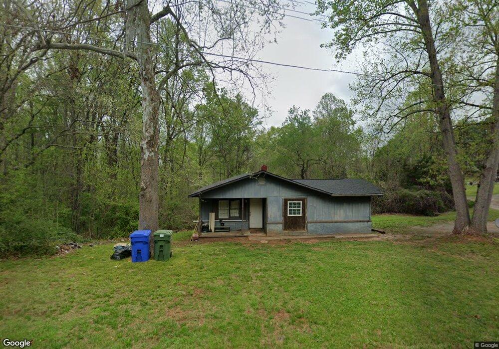
679 Whiteside Rd Rutherfordton, NC 28139
Estimated Value: $148,000 - $382,000
3
Beds
1
Bath
1,080
Sq Ft
$215/Sq Ft
Est. Value
About This Home
This home is located at 679 Whiteside Rd, Rutherfordton, NC 28139 and is currently estimated at $232,333, approximately $215 per square foot. 679 Whiteside Rd is a home located in Rutherford County with nearby schools including Mt. Vernon-Ruth Elementary School, R.S. Middle School, and R-S Central High School.
Ownership History
Date
Name
Owned For
Owner Type
Purchase Details
Closed on
Jan 7, 2022
Sold by
Thomas Teubner Scott
Bought by
Tomberlin Kevin Scott
Current Estimated Value
Purchase Details
Closed on
Oct 6, 2020
Sold by
Kunkle Floyd E and Kunkle Virginia A
Bought by
Teubner Scott Thomas
Home Financials for this Owner
Home Financials are based on the most recent Mortgage that was taken out on this home.
Original Mortgage
$700,000
Interest Rate
2.8%
Create a Home Valuation Report for This Property
The Home Valuation Report is an in-depth analysis detailing your home's value as well as a comparison with similar homes in the area
Home Values in the Area
Average Home Value in this Area
Purchase History
| Date | Buyer | Sale Price | Title Company |
|---|---|---|---|
| Tomberlin Kevin Scott | $38,000 | Willis Jarald N | |
| Teubner Scott Thomas | $51,500 | None Available |
Source: Public Records
Mortgage History
| Date | Status | Borrower | Loan Amount |
|---|---|---|---|
| Previous Owner | Teubner Scott Thomas | $700,000 |
Source: Public Records
Tax History Compared to Growth
Tax History
| Year | Tax Paid | Tax Assessment Tax Assessment Total Assessment is a certain percentage of the fair market value that is determined by local assessors to be the total taxable value of land and additions on the property. | Land | Improvement |
|---|---|---|---|---|
| 2025 | $802 | $100,500 | $11,600 | $88,900 |
| 2024 | $737 | $100,500 | $11,600 | $88,900 |
| 2023 | $508 | $100,500 | $11,600 | $88,900 |
| 2022 | $508 | $49,900 | $11,600 | $38,300 |
| 2021 | $503 | $49,900 | $11,600 | $38,300 |
| 2020 | $503 | $49,900 | $11,600 | $38,300 |
| 2019 | $495 | $49,900 | $11,600 | $38,300 |
| 2018 | $407 | $38,000 | $7,500 | $30,500 |
| 2016 | $385 | $38,000 | $7,500 | $30,500 |
| 2013 | -- | $38,000 | $7,500 | $30,500 |
Source: Public Records
Map
Nearby Homes
- 117 Kingston Place
- 115 Kingston Place
- 105 Kingston Place
- 130 Bartley St
- 125 Charleston Ct
- 160 Central Park Cir
- 136 Augusta Dr
- 126 Campbell St
- 496 Spindale St
- 0 US 64 Hwy Unit CAR4308479
- 140 Power St
- 0 Hutchins Dr Unit 14,15 CAR4269724
- 00 Old Ballpark Rd
- 00 Old Ballpark Rd Unit LotWP001
- 0 Pineview Dr Unit CAR4304160
- 1074 Old Ballpark Rd
- 365 Rock Rd
- 00 Ledbetter Rd
- 230 Old United States Highway 221 N
- 182 Autumn Ln
- 661 Whiteside Rd
- 120 Cassidy Dr
- 694 Whiteside Rd
- 689 Whiteside Rd
- 117 Cassidy Dr
- 651 Whiteside Rd Unit 655
- 691 Whiteside Rd
- 647 Whiteside Rd
- 31 acres Old Mill Rd(big-Bold Creek ) Unit 3
- Lot 22 Creek
- 639 Whiteside Rd
- 00 Whitesides Rd
- 724 Whiteside Rd
- 579 Whiteside Rd
- 107 Dove Ln
- 575 Whiteside Rd Unit 577
- 565 Whiteside Rd
- 793 Whiteside Rd Unit 849
- 149 Dove Ln
- 161 Dove Ln