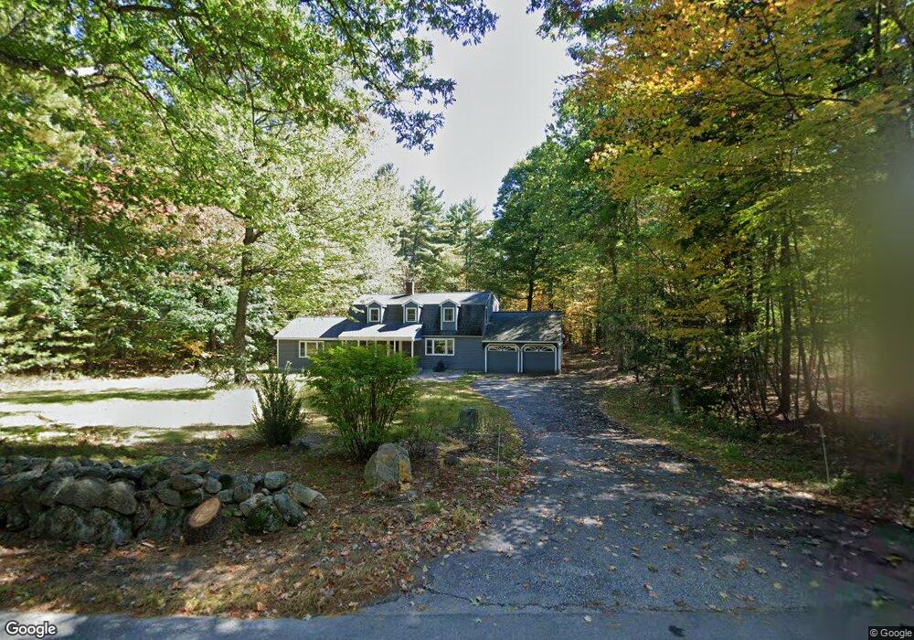
68 Cleveland Hill Rd Brookline, NH 03033
Estimated Value: $652,200 - $733,000
3
Beds
2
Baths
3,282
Sq Ft
$216/Sq Ft
Est. Value
About This Home
This home is located at 68 Cleveland Hill Rd, Brookline, NH 03033 and is currently estimated at $707,550, approximately $215 per square foot. 68 Cleveland Hill Rd is a home with nearby schools including Richard Maghakian Memorial School, Captain Samuel Douglass Academy, and Hollis-Brookline Middle School.
Ownership History
Date
Name
Owned For
Owner Type
Purchase Details
Closed on
May 20, 1996
Sold by
Razzaboni George L and Razzaboni Amy J
Bought by
Rosenberg Alan N and Rosenberg Patricia M
Current Estimated Value
Home Financials for this Owner
Home Financials are based on the most recent Mortgage that was taken out on this home.
Original Mortgage
$120,000
Interest Rate
7.77%
Create a Home Valuation Report for This Property
The Home Valuation Report is an in-depth analysis detailing your home's value as well as a comparison with similar homes in the area
Home Values in the Area
Average Home Value in this Area
Purchase History
| Date | Buyer | Sale Price | Title Company |
|---|---|---|---|
| Rosenberg Alan N | $150,000 | -- |
Source: Public Records
Mortgage History
| Date | Status | Borrower | Loan Amount |
|---|---|---|---|
| Open | Rosenberg Alan N | $150,000 | |
| Closed | Rosenberg Alan N | $120,000 |
Source: Public Records
Tax History Compared to Growth
Tax History
| Year | Tax Paid | Tax Assessment Tax Assessment Total Assessment is a certain percentage of the fair market value that is determined by local assessors to be the total taxable value of land and additions on the property. | Land | Improvement |
|---|---|---|---|---|
| 2024 | $13,116 | $580,100 | $191,400 | $388,700 |
| 2023 | $12,054 | $580,100 | $191,400 | $388,700 |
| 2022 | $10,500 | $353,300 | $115,300 | $238,000 |
| 2021 | $10,097 | $353,300 | $115,300 | $238,000 |
| 2020 | $9,822 | $353,300 | $115,300 | $238,000 |
| 2019 | $10,553 | $353,300 | $115,300 | $238,000 |
| 2018 | $10,444 | $353,300 | $115,300 | $238,000 |
| 2017 | $9,655 | $293,100 | $93,300 | $199,800 |
| 2016 | $9,354 | $287,300 | $93,300 | $194,000 |
| 2015 | $8,921 | $287,300 | $93,300 | $194,000 |
| 2014 | $9,438 | $287,300 | $93,300 | $194,000 |
| 2013 | $9,087 | $287,300 | $93,300 | $194,000 |
Source: Public Records
Map
Nearby Homes
- 9 Winterberry Rd
- 7 Winterberry Rd
- 15 N End Rd
- 364 Townsend Hill Rd
- 1235 Townsend Rd
- 167 Route 13
- 46 Oak Hill Rd
- 0 Brookline St
- 55 Oak Hill Rd
- 22 Hobart Hill Rd
- 6 Flint Meadow Dr
- 6 High Oaks Path
- 64 Meadow Rd
- 28A Rocky Pond Rd
- 5 Carons Way
- 93 Old Milford Rd
- 21 Cranberry St
- 38 Countryside Dr
- 104 N Mason Rd
- 1275 Valley Rd
- 70 Cleveland Hill Rd
- 69 Cleveland Hill Rd
- 65 Cleveland Hill Rd
- 67 Cleveland Hill Rd
- 72 Cleveland Hill Rd
- 63 Cleveland Hill Rd
- 74 Cleveland Hill Rd
- 0 Cleveland Hill Rd
- 61 Cleveland Hill Rd
- 23 Taylor Dr
- 21 Taylor Dr
- 25 Taylor Dr
- 73 Averill Rd
- 79 Averill Rd
- 27 Taylor Dr
- 12 Winterberry Rd
- 15 Taylor Dr
- 26 Taylor Dr
- 76 Averill Rd
- 14 Winterberry Rd