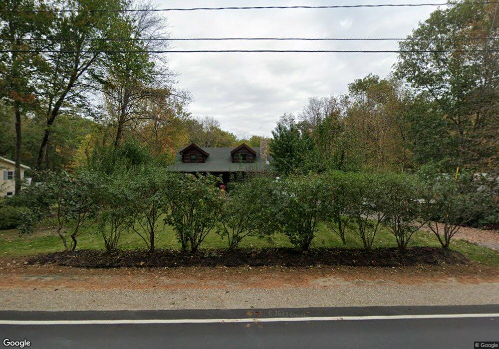
68 Jewett Rd Dunbarton, NH 03046
Estimated Value: $465,206 - $519,000
3
Beds
1
Bath
1,512
Sq Ft
$331/Sq Ft
Est. Value
About This Home
This home is located at 68 Jewett Rd, Dunbarton, NH 03046 and is currently estimated at $500,302, approximately $330 per square foot. 68 Jewett Rd is a home located in Merrimack County with nearby schools including Dunbarton Elementary School, Bow Memorial School, and Bow High School.
Ownership History
Date
Name
Owned For
Owner Type
Purchase Details
Closed on
Aug 11, 2022
Sold by
Pelletier David and Pelletier Deanne M
Bought by
David A Pelletier Ret
Current Estimated Value
Purchase Details
Closed on
Nov 24, 1999
Sold by
Dobbins David C
Bought by
Pelletier David A and Pelletier Deanne M
Home Financials for this Owner
Home Financials are based on the most recent Mortgage that was taken out on this home.
Original Mortgage
$123,250
Interest Rate
7.77%
Create a Home Valuation Report for This Property
The Home Valuation Report is an in-depth analysis detailing your home's value as well as a comparison with similar homes in the area
Home Values in the Area
Average Home Value in this Area
Purchase History
| Date | Buyer | Sale Price | Title Company |
|---|---|---|---|
| David A Pelletier Ret | -- | None Available | |
| Pelletier David A | $145,000 | -- |
Source: Public Records
Mortgage History
| Date | Status | Borrower | Loan Amount |
|---|---|---|---|
| Previous Owner | Pelletier David A | $60,000 | |
| Previous Owner | Pelletier David A | $123,250 |
Source: Public Records
Tax History Compared to Growth
Tax History
| Year | Tax Paid | Tax Assessment Tax Assessment Total Assessment is a certain percentage of the fair market value that is determined by local assessors to be the total taxable value of land and additions on the property. | Land | Improvement |
|---|---|---|---|---|
| 2024 | $7,418 | $281,200 | $90,300 | $190,900 |
| 2023 | $7,190 | $281,200 | $90,300 | $190,900 |
| 2022 | $6,462 | $281,200 | $90,300 | $190,900 |
| 2021 | $6,583 | $281,200 | $90,300 | $190,900 |
| 2020 | $6,265 | $281,200 | $90,300 | $190,900 |
| 2018 | $4,824 | $214,100 | $68,100 | $146,000 |
| 2017 | $5,483 | $214,100 | $68,100 | $146,000 |
| 2016 | $5,134 | $214,100 | $68,100 | $146,000 |
| 2015 | $5,051 | $214,100 | $68,100 | $146,000 |
| 2014 | $4,809 | $227,500 | $68,100 | $159,400 |
| 2013 | $4,780 | $227,500 | $68,100 | $159,400 |
Source: Public Records
Map
Nearby Homes
- 256-0-17 Jewett Rd
- 0 Farrington Corner Rd Unit 14
- I3-03-05 Clinton St
- 167 Branch Londonderry Turnpike
- 40 N Woods Rd
- 250 Grapevine Rd
- 490 Page Rd
- 541 South Rd
- 0 George Rd Unit 30
- 27 Brushwood Dr
- 8 Longview Dr
- 464 Irish Hill Rd
- 5 Longview Dr
- 256 Irish Hill Rd
- 102 Fieldstone Rd
- 57 Lyndsey Ln
- 70 Gile Hill Rd
- 89 Old Henniker Rd
- 0 Als Dr Unit 196
- 7 Currier Rd