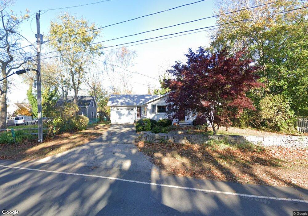
68 Langsford St Gloucester, MA 01930
Estimated Value: $666,000 - $940,000
2
Beds
1
Bath
1,148
Sq Ft
$674/Sq Ft
Est. Value
About This Home
This home is located at 68 Langsford St, Gloucester, MA 01930 and is currently estimated at $773,358, approximately $673 per square foot. 68 Langsford St is a home located in Essex County with nearby schools including Plum Cove School, Ralph B O'maley Middle School, and Gloucester High School.
Ownership History
Date
Name
Owned For
Owner Type
Purchase Details
Closed on
Feb 24, 2025
Sold by
Dinardi Susan J
Bought by
Susan J Dinardi 2025 Ret and Dinardi
Current Estimated Value
Purchase Details
Closed on
Feb 15, 2002
Sold by
Pulkka Gertrude M Est
Bought by
Dinardi Susan J and Dinardi Paul R
Create a Home Valuation Report for This Property
The Home Valuation Report is an in-depth analysis detailing your home's value as well as a comparison with similar homes in the area
Purchase History
| Date | Buyer | Sale Price | Title Company |
|---|---|---|---|
| Susan J Dinardi 2025 Ret | -- | None Available | |
| Susan J Dinardi 2025 Ret | -- | None Available | |
| Susan J Dinardi 2025 Ret | -- | None Available | |
| Dinardi Susan J | $300,000 | -- | |
| Dinardi Susan J | $300,000 | -- |
Source: Public Records
Mortgage History
| Date | Status | Borrower | Loan Amount |
|---|---|---|---|
| Previous Owner | Dinardi Susan J | $201,000 | |
| Previous Owner | Dinardi Susan J | $208,000 | |
| Previous Owner | Dinardi Susan J | $40,000 |
Source: Public Records
Tax History
| Year | Tax Paid | Tax Assessment Tax Assessment Total Assessment is a certain percentage of the fair market value that is determined by local assessors to be the total taxable value of land and additions on the property. | Land | Improvement |
|---|---|---|---|---|
| 2025 | $5,854 | $602,300 | $265,800 | $336,500 |
| 2024 | $5,685 | $584,300 | $253,100 | $331,200 |
| 2023 | $5,810 | $548,600 | $226,000 | $322,600 |
| 2022 | $5,452 | $464,800 | $192,200 | $272,600 |
| 2021 | $5,464 | $439,200 | $174,700 | $264,500 |
| 2020 | $5,132 | $416,200 | $174,700 | $241,500 |
| 2019 | $5,103 | $402,100 | $174,700 | $227,400 |
| 2018 | $5,054 | $390,900 | $174,700 | $216,200 |
| 2017 | $4,921 | $373,100 | $166,300 | $206,800 |
| 2016 | $4,700 | $345,300 | $166,800 | $178,500 |
| 2015 | $4,640 | $339,900 | $166,800 | $173,100 |
Source: Public Records
Map
Nearby Homes
- 10 Emerald St
- 43 High St Unit B
- 7 Colburn St
- 94 Phillips Ave
- 13 Phillips Ave
- 32 Haven Ave
- 33 Quarry Ridge Ln Unit 33
- 5 Smith St Unit R
- 1 Main St Unit R
- 1 Main St Unit C
- 1 Charte Ct
- 177 Main St
- 672 Washington St
- 4 Norwood Ave
- 16 Hodgkins Rd Unit 2
- 27 Hodgkins Rd
- 34R Summer St
- 226 Atlantic St
- 2 Breezy Point Rd
- 2 Finch Ln
- 66 Langsford St Unit 2
- 66 Langsford St Unit 1
- 66 Langsford St
- 66 Langsford St Unit R
- 64 Langsford St
- 8 Rockwood Ln
- 74 Langsford St
- 14 Rockwood Ln
- 10 Rockwood Ln
- 60 Langsford St
- 3 Rockwood Ln
- 3 Rockwood Ln Unit 1
- 5 Viking St Unit C
- 5 Viking St Unit B
- 5 Viking St Unit A
- 5 Viking St
- 63 Langsford St
- 12 Coggeshall Rd
- 76 Langsford St
- 73 Langsford St
Your Personal Tour Guide
Ask me questions while you tour the home.