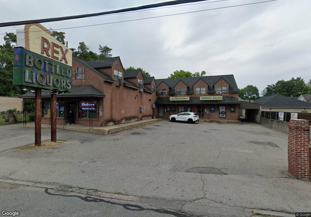
68 Mammoth Rd Lowell, MA 01854
Pawtucketville NeighborhoodEstimated Value: $2,070,756
7
Beds
6
Baths
8,402
Sq Ft
$246/Sq Ft
Est. Value
About This Home
This home is located at 68 Mammoth Rd, Lowell, MA 01854 and is currently estimated at $2,070,756, approximately $246 per square foot. 68 Mammoth Rd is a home located in Middlesex County with nearby schools including Joseph McAvinnue Elementary School, Charlotte M. Murkland Elementary School, and Charles W. Morey Elementary School.
Ownership History
Date
Name
Owned For
Owner Type
Purchase Details
Closed on
Aug 23, 2004
Sold by
Canaco Inc
Bought by
Kurcel Rt and Santos
Current Estimated Value
Home Financials for this Owner
Home Financials are based on the most recent Mortgage that was taken out on this home.
Original Mortgage
$500,000
Outstanding Balance
$248,437
Interest Rate
6.03%
Mortgage Type
Commercial
Estimated Equity
$1,822,319
Purchase Details
Closed on
Mar 20, 2003
Sold by
Oak T and Sergu
Bought by
Santos Tr Kenneth M and Kurcel Rt
Home Financials for this Owner
Home Financials are based on the most recent Mortgage that was taken out on this home.
Original Mortgage
$513,750
Interest Rate
5.9%
Mortgage Type
Commercial
Create a Home Valuation Report for This Property
The Home Valuation Report is an in-depth analysis detailing your home's value as well as a comparison with similar homes in the area
Home Values in the Area
Average Home Value in this Area
Purchase History
| Date | Buyer | Sale Price | Title Company |
|---|---|---|---|
| Kurcel Rt | -- | -- | |
| Kurcel Rt | -- | -- | |
| Kurcel Rt | -- | -- | |
| Kurcel Rt | -- | -- | |
| Kurcel Rt | -- | -- | |
| Santos Tr Kenneth M | $875,000 | -- | |
| Santos Tr Kenneth M | $875,000 | -- |
Source: Public Records
Mortgage History
| Date | Status | Borrower | Loan Amount |
|---|---|---|---|
| Open | Kurcel Rt | $500,000 | |
| Closed | Kurcel Rt | $225,000 | |
| Closed | Santos Tr Kenneth M | $500,000 | |
| Previous Owner | Santos Tr Kenneth M | $513,750 |
Source: Public Records
Tax History Compared to Growth
Tax History
| Year | Tax Paid | Tax Assessment Tax Assessment Total Assessment is a certain percentage of the fair market value that is determined by local assessors to be the total taxable value of land and additions on the property. | Land | Improvement |
|---|---|---|---|---|
| 2025 | $14,901 | $666,100 | $75,500 | $590,600 |
| 2024 | $14,942 | $642,100 | $75,500 | $566,600 |
| 2023 | $14,779 | $606,700 | $75,500 | $531,200 |
| 2022 | $0 | $591,500 | $75,500 | $516,000 |
| 2021 | $0 | $566,200 | $75,500 | $490,700 |
| 2020 | $13,805 | $515,700 | $75,500 | $440,200 |
| 2019 | $0 | $500,500 | $75,500 | $425,000 |
| 2018 | $0 | $465,200 | $75,500 | $389,700 |
| 2017 | $0 | $450,000 | $75,500 | $374,500 |
| 2016 | $6,222 | $420,700 | $75,500 | $345,200 |
| 2015 | $6,222 | $420,700 | $75,500 | $345,200 |
| 2013 | $6,222 | $414,500 | $75,500 | $339,000 |
Source: Public Records
Map
Nearby Homes