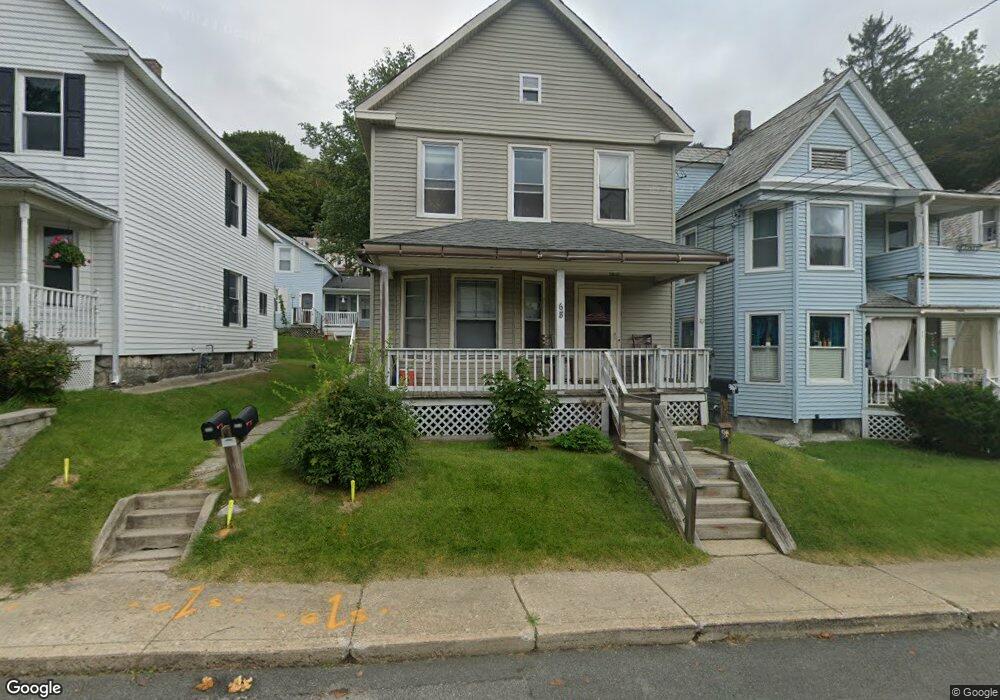
68 Meadow St North Adams, MA 01247
Estimated Value: $152,000 - $193,000
3
Beds
2
Baths
1,669
Sq Ft
$107/Sq Ft
Est. Value
About This Home
This home is located at 68 Meadow St, North Adams, MA 01247 and is currently estimated at $178,161, approximately $106 per square foot. 68 Meadow St is a home located in Berkshire County with nearby schools including Colegrove Park Elementary School and Drury High School.
Ownership History
Date
Name
Owned For
Owner Type
Purchase Details
Closed on
Sep 1, 2010
Sold by
Amidon William G and Amidon Pamela H
Bought by
Zusammen Llc
Current Estimated Value
Purchase Details
Closed on
May 9, 2006
Sold by
Amidon Bradford and Amidon Pamela H
Bought by
Amidon Pamela H and Amidon William G
Purchase Details
Closed on
Apr 30, 2004
Sold by
Bishop Corey J and Bishop Gwenn D
Bought by
Amidon William G and Amidon Pamela H
Home Financials for this Owner
Home Financials are based on the most recent Mortgage that was taken out on this home.
Original Mortgage
$56,250
Interest Rate
5.36%
Mortgage Type
Purchase Money Mortgage
Purchase Details
Closed on
Apr 25, 1997
Sold by
Hunter Elizabeth M
Bought by
Ruebel Gwenn D
Create a Home Valuation Report for This Property
The Home Valuation Report is an in-depth analysis detailing your home's value as well as a comparison with similar homes in the area
Home Values in the Area
Average Home Value in this Area
Purchase History
| Date | Buyer | Sale Price | Title Company |
|---|---|---|---|
| Zusammen Llc | $220,000 | -- | |
| Zusammen Llc | $220,000 | -- | |
| Amidon Pamela H | $35,000 | -- | |
| Amidon Pamela H | $35,000 | -- | |
| Amidon William G | $75,000 | -- | |
| Amidon William G | $75,000 | -- | |
| Ruebel Gwenn D | $30,000 | -- | |
| Ruebel Gwenn D | $30,000 | -- |
Source: Public Records
Mortgage History
| Date | Status | Borrower | Loan Amount |
|---|---|---|---|
| Previous Owner | Ruebel Gwenn D | $56,250 | |
| Previous Owner | Ruebel Gwenn D | $18,000 |
Source: Public Records
Tax History Compared to Growth
Tax History
| Year | Tax Paid | Tax Assessment Tax Assessment Total Assessment is a certain percentage of the fair market value that is determined by local assessors to be the total taxable value of land and additions on the property. | Land | Improvement |
|---|---|---|---|---|
| 2025 | $2,388 | $142,900 | $24,700 | $118,200 |
| 2024 | $2,242 | $130,800 | $22,600 | $108,200 |
| 2023 | $1,995 | $112,900 | $22,600 | $90,300 |
| 2022 | $1,953 | $105,400 | $22,600 | $82,800 |
| 2021 | $1,816 | $97,600 | $20,900 | $76,700 |
| 2020 | $1,748 | $93,900 | $20,000 | $73,900 |
| 2019 | $1,752 | $91,700 | $20,400 | $71,300 |
| 2018 | $1,728 | $94,000 | $21,900 | $72,100 |
| 2017 | $1,645 | $93,100 | $21,700 | $71,400 |
| 2016 | $1,626 | $93,500 | $21,700 | $71,800 |
| 2015 | $1,572 | $94,200 | $22,400 | $71,800 |
Source: Public Records
Map
Nearby Homes
- 67 Cherry St
- 30 Dover St
- 31 Dover St
- 74 Washington Ave
- 11-15 Perry St
- 194 E Main St
- 50 Gallup St
- 0 Church St
- 306 Union St
- 23-27 Gallup St
- 19 N Church St Unit 11
- 19 N Church St Unit 14
- 19 N Church St Unit 12
- 19 N Church St Unit 7
- 35 Jackson St
- 26 Bradford St
- 159 Eagle St
- 0 Mohawk Trail
- 33 Hudson St
- 209 Corinth St