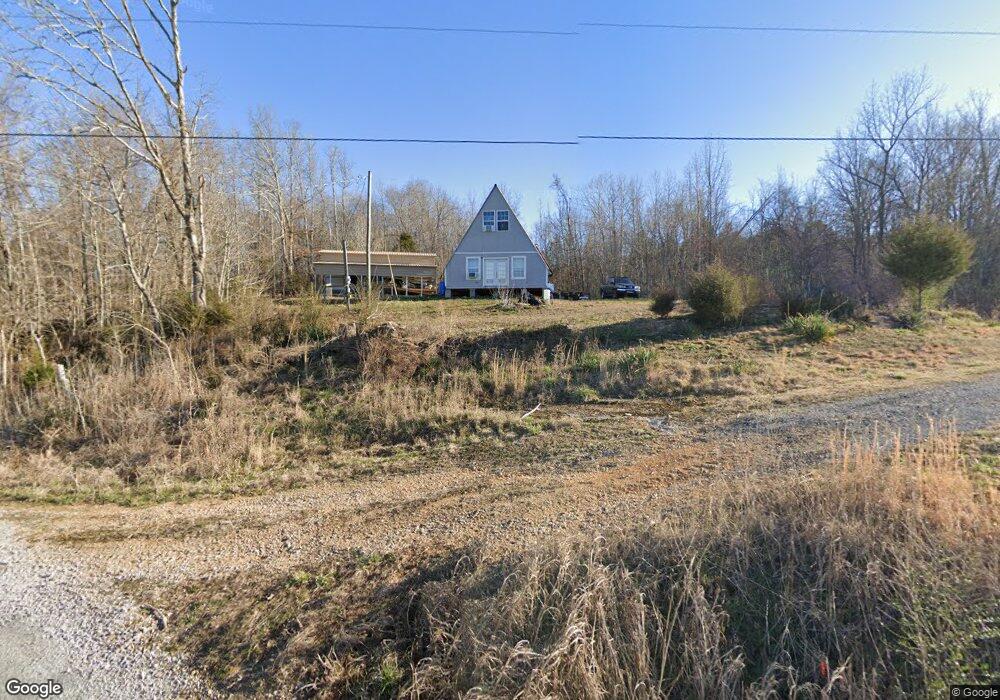
680 Carlew Rd Waynesboro, TN 38485
Estimated Value: $115,000 - $234,000
--
Bed
--
Bath
676
Sq Ft
$269/Sq Ft
Est. Value
About This Home
This home is located at 680 Carlew Rd, Waynesboro, TN 38485 and is currently estimated at $181,750, approximately $268 per square foot. 680 Carlew Rd is a home located in Wayne County.
Ownership History
Date
Name
Owned For
Owner Type
Purchase Details
Closed on
May 31, 2018
Sold by
Jones Mason Riley
Bought by
Butler Cynthia Ann and Butler Larry Kevin
Current Estimated Value
Purchase Details
Closed on
Jul 31, 2008
Sold by
Andrew Stewart Raymond
Bought by
Mason Jones
Home Financials for this Owner
Home Financials are based on the most recent Mortgage that was taken out on this home.
Original Mortgage
$30,250
Interest Rate
6.31%
Purchase Details
Closed on
Jan 7, 2005
Sold by
Kathleen Stewart
Bought by
Andrew Stewart Raymond
Home Financials for this Owner
Home Financials are based on the most recent Mortgage that was taken out on this home.
Original Mortgage
$10,830
Interest Rate
5.61%
Create a Home Valuation Report for This Property
The Home Valuation Report is an in-depth analysis detailing your home's value as well as a comparison with similar homes in the area
Home Values in the Area
Average Home Value in this Area
Purchase History
| Date | Buyer | Sale Price | Title Company |
|---|---|---|---|
| Butler Cynthia Ann | $25,000 | -- | |
| Mason Jones | $25,000 | -- | |
| Andrew Stewart Raymond | $10,214 | -- |
Source: Public Records
Mortgage History
| Date | Status | Borrower | Loan Amount |
|---|---|---|---|
| Previous Owner | Andrew Stewart Raymond | $30,250 | |
| Previous Owner | Andrew Stewart Raymond | $10,830 |
Source: Public Records
Tax History Compared to Growth
Tax History
| Year | Tax Paid | Tax Assessment Tax Assessment Total Assessment is a certain percentage of the fair market value that is determined by local assessors to be the total taxable value of land and additions on the property. | Land | Improvement |
|---|---|---|---|---|
| 2024 | $431 | $19,875 | $5,475 | $14,400 |
| 2023 | $381 | $19,875 | $5,475 | $14,400 |
| 2022 | $114 | $5,925 | $5,475 | $450 |
| 2021 | $139 | $5,925 | $5,475 | $450 |
| 2020 | $139 | $6,050 | $5,575 | $475 |
| 2019 | $139 | $6,050 | $5,575 | $475 |
| 2018 | $139 | $6,050 | $5,575 | $475 |
| 2017 | $139 | $6,050 | $5,575 | $475 |
| 2016 | $114 | $6,050 | $5,575 | $475 |
| 2014 | $121 | $5,850 | $0 | $0 |
Source: Public Records
Map
Nearby Homes
- 148 J Harris Trail
- 2270 Waynesboro Hwy
- 0K Hohenwald Hwy
- 0J Hohenwald Hwy
- 0I Hohenwald Hwy
- 0 Hohenwald Hwy Unit RTC2789243
- 0A Hohenwald Hwy
- 0G Toll Hollow Rd
- 0F Toll Hollow Rd
- 0C Toll Hollow Rd
- 0D Toll Hollow Rd
- 0H Toll Hollow Rd
- 0B Toll Hollow Rd
- 0E Toll Hollow Rd
- 245 Horseshoe Bend Rd
- 293 Horseshoe Bend Rd
- 339 Flatwoods School Rd
- 0 Phillips Chapel Rd
- 2411 Keazey Hollow Rd
- Big Opposum Creek Rd
- 0 Carlew Rd Unit 2019396
- 2505 Waynesboro Hwy
- 2505 Waynesboro Hwy
- 2500 Waynesboro Hwy
- 2355 Mayberry Rd
- 2510 Waynesboro Hwy
- 2335 Mayberry Rd
- 2840 Waynesboro Hwy
- 2855 Waynesboro Hwy
- 2330 Mayberry Rd
- 2546 Highway 13
- 2310 Mayberry Rd
- 130 J M Pope Rd
- 0 Alfred Ray Unit 1757274
- 99 Reeves Ln
- 115 J M Pope Rd
- 2945 Waynesboro Hwy
- 0 Alfred Ray Rd Unit 1963415
- 0 Alfred Ray Rd Unit 1963414
- 0 Alfred Ray Rd Unit 1963409