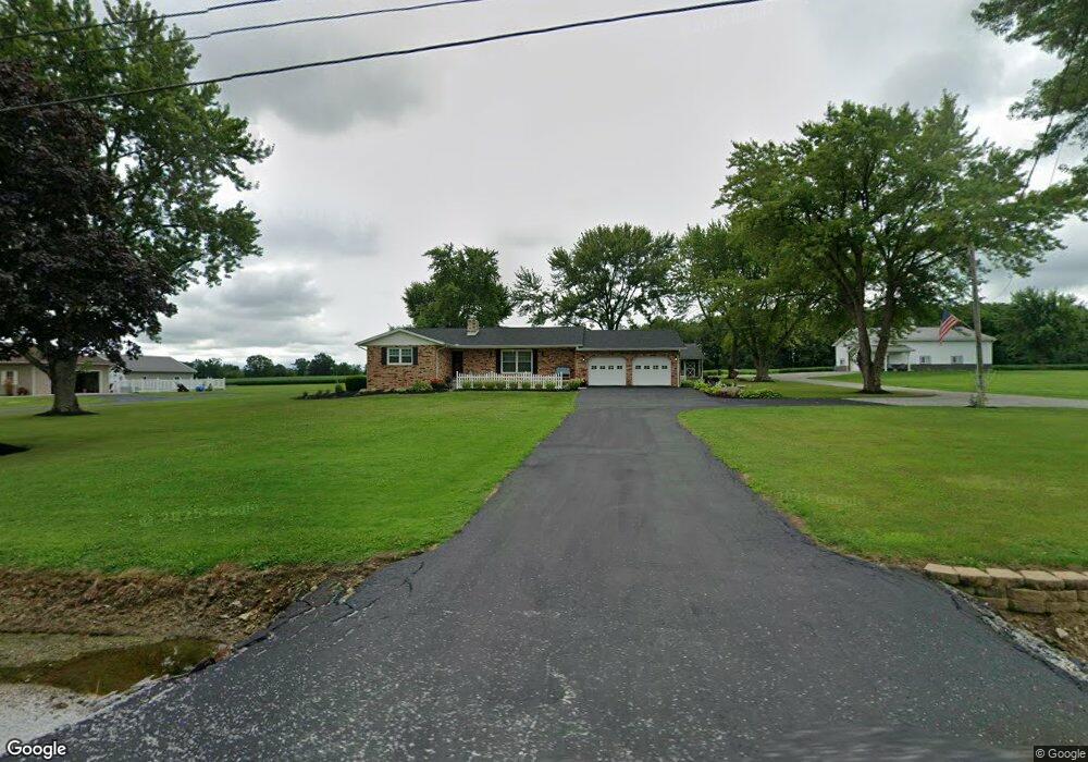
6804 State Route 88 Kinsman, OH 44428
Estimated Value: $190,000 - $301,000
3
Beds
1
Bath
1,509
Sq Ft
$162/Sq Ft
Est. Value
About This Home
This home is located at 6804 State Route 88, Kinsman, OH 44428 and is currently estimated at $244,569, approximately $162 per square foot. 6804 State Route 88 is a home located in Trumbull County with nearby schools including Badger Elementary School, Badger Middle School, and Badger High School.
Ownership History
Date
Name
Owned For
Owner Type
Purchase Details
Closed on
Oct 25, 2021
Sold by
Harnett Douglas A and Donald L Harnett Family Trust
Bought by
Harnett Michael R and Harnett Sharina L
Current Estimated Value
Purchase Details
Closed on
Nov 16, 2016
Sold by
Harnett Michael R and Harnett Sharina L
Bought by
Harnett Michael R and Harnett Sharina L
Purchase Details
Closed on
Nov 14, 2016
Sold by
Harnett Donald L and Harnett Carolyn J
Bought by
Harnett Michael R and Harnett Sharina L
Purchase Details
Closed on
Jan 1, 1990
Bought by
Michael R Harnett
Create a Home Valuation Report for This Property
The Home Valuation Report is an in-depth analysis detailing your home's value as well as a comparison with similar homes in the area
Home Values in the Area
Average Home Value in this Area
Purchase History
| Date | Buyer | Sale Price | Title Company |
|---|---|---|---|
| Harnett Michael R | $9,500 | None Available | |
| Harnett Michael R | -- | None Available | |
| Harnett Michael R | -- | None Available | |
| Michael R Harnett | -- | -- |
Source: Public Records
Tax History Compared to Growth
Tax History
| Year | Tax Paid | Tax Assessment Tax Assessment Total Assessment is a certain percentage of the fair market value that is determined by local assessors to be the total taxable value of land and additions on the property. | Land | Improvement |
|---|---|---|---|---|
| 2024 | $3,615 | $85,330 | $7,630 | $77,700 |
| 2023 | $3,615 | $85,330 | $7,630 | $77,700 |
| 2022 | $3,249 | $69,340 | $6,930 | $62,410 |
| 2021 | $3,108 | $66,360 | $6,930 | $59,430 |
| 2020 | $2,769 | $58,870 | $6,930 | $51,940 |
| 2019 | $2,670 | $53,630 | $6,410 | $47,220 |
| 2018 | $2,591 | $53,630 | $6,410 | $47,220 |
| 2017 | $2,585 | $53,630 | $6,410 | $47,220 |
| 2016 | $2,213 | $46,350 | $3,190 | $43,160 |
| 2015 | $2,211 | $46,350 | $3,190 | $43,160 |
| 2014 | $2,210 | $46,350 | $3,190 | $43,160 |
| 2013 | $2,323 | $46,350 | $3,190 | $43,160 |
Source: Public Records
Map
Nearby Homes
- 6521 State Route 7
- 6261 State Route 88
- 6027 Ohio 88
- 5961 Sodom Hutchings Rd
- 209 N State Line Rd
- 7932 Wayland Ave
- 6498 Stoddard Hayes Rd
- 4016 State Route 7
- 7850 State Route 609
- 7529 State Line
- 8304 State St
- 8365 Main St
- 4366 Greenville Rd
- 8476 Main St
- 6148 Youngstown Kingsville Rd
- 6664 Park Dr
- 6277 Youngstown Kingsville Rd
- 69 S Summit Rd Unit 513
- 69 S Summit Rd Unit 205
- 73 S Summit Rd Unit 510
- 6816 State Route 88
- 6702 State Route 88
- 6840 State Route 88
- 6840 Ohio 88
- 6761 State Route 88
- 6777 State Route 88
- 6500 State Route 88
- 6787 State Route 88
- 6623 State Route 88
- 6825 State Route 88
- 6603 State Route 88
- 4211 State Route 88
- 4227 State Route 88
- 6922 Ohio 88
- 6922 State Route 88
- 6047 State Route 7
- 6099 State Route 7
- 6099 State Route 7
- 6099 Youngstown Conneaut Rd
- 6073 State Route 7