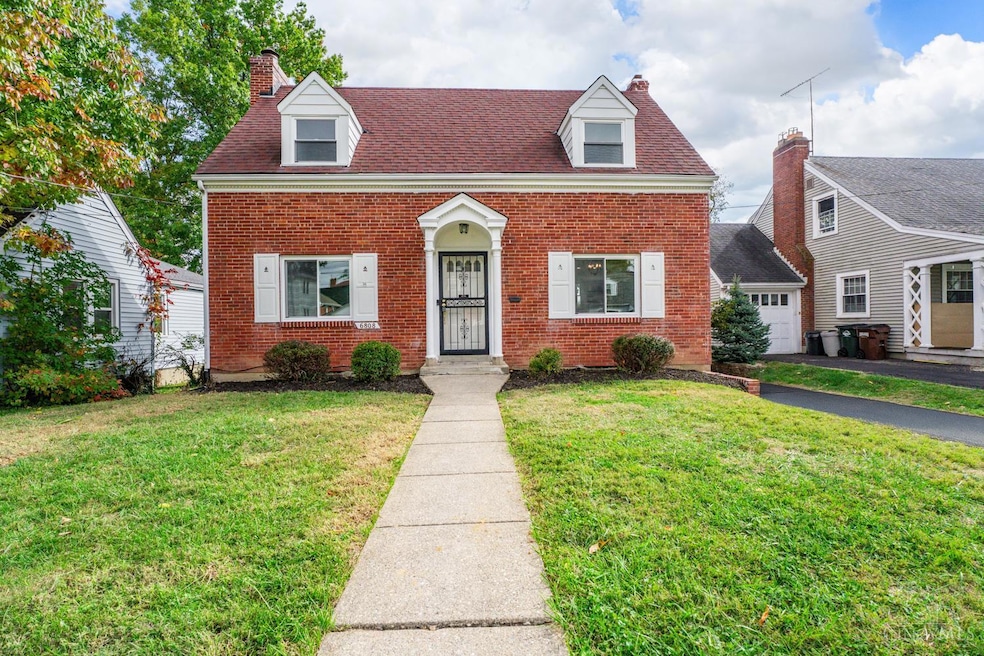
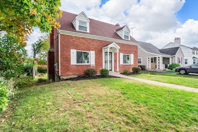
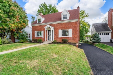
6808 Sampson Ln Cincinnati, OH 45236
Estimated payment $1,772/month
Highlights
- Cape Cod Architecture
- Marble Flooring
- Sun or Florida Room
- Walnut Hills High School Rated A+
- Bonus Room
- No HOA
About This Home
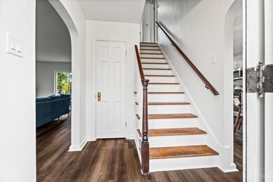
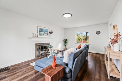
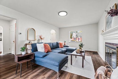
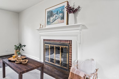
Fully renovated brick Cape Cod with timeless style and modern updates. The open main level connects a bright living room, dining area, and a sleek white kitchen with quartz countertops, stainless appliances, and a standout butler's pantry. A sunny three-season room extends the living space and overlooks the backyard. Upstairs, two spacious bedrooms include a primary suite with a cedar-lined closet, while the second bedroom features a hidden storage closet. A convenient laundry chute adds everyday practicality. The full bath offers updated tile and fixtures, and the lower level includes a half bath with a built-in dog wash tub plus a bonus storage room. Fresh paint, new flooring, and modern lighting throughout. Move-in ready on a quiet, convenient street close to parks, shops, and restaurants. Home Warranty Included!
Home Details
Home Type
- Single Family
Est. Annual Taxes
- $2,352
Year Built
- Built in 1937
Lot Details
- 8,146 Sq Ft Lot
- Cleared Lot
Parking
- 1 Car Garage
- Rear-Facing Garage
- Driveway
Home Design
- Cape Cod Architecture
- Brick Exterior Construction
- Poured Concrete
- Shingle Roof
Interior Spaces
- 1,267 Sq Ft Home
- 1.5-Story Property
- Chandelier
- Vinyl Clad Windows
- Double Hung Windows
- Bonus Room
- Sun or Florida Room
Kitchen
- Butlers Pantry
- Oven or Range
- Dishwasher
- Kitchen Island
- Disposal
Flooring
- Wood
- Marble
Bedrooms and Bathrooms
- 2 Bedrooms
- Bathtub with Shower
Laundry
- Dryer
- Washer
- Laundry Chute
Basement
- Basement Fills Entire Space Under The House
- Sump Pump
Accessible Home Design
- Smart Technology
Utilities
- Forced Air Heating and Cooling System
- Gas Water Heater
Community Details
- No Home Owners Association
Map
Home Values in the Area
Average Home Value in this Area
Tax History
| Year | Tax Paid | Tax Assessment Tax Assessment Total Assessment is a certain percentage of the fair market value that is determined by local assessors to be the total taxable value of land and additions on the property. | Land | Improvement |
|---|---|---|---|---|
| 2024 | $2,353 | $51,381 | $12,170 | $39,211 |
| 2023 | $2,455 | $51,381 | $12,170 | $39,211 |
| 2022 | $1,719 | $33,768 | $9,156 | $24,612 |
| 2021 | $1,661 | $33,768 | $9,156 | $24,612 |
| 2020 | $1,704 | $33,768 | $9,156 | $24,612 |
| 2019 | $1,839 | $33,107 | $8,978 | $24,129 |
| 2018 | $1,842 | $33,107 | $8,978 | $24,129 |
| 2017 | $1,751 | $33,107 | $8,978 | $24,129 |
| 2016 | $1,646 | $31,347 | $8,082 | $23,265 |
| 2015 | $1,496 | $31,347 | $8,082 | $23,265 |
| 2014 | $1,507 | $31,347 | $8,082 | $23,265 |
| 2013 | $1,770 | $34,829 | $8,978 | $25,851 |
Property History
| Date | Event | Price | List to Sale | Price per Sq Ft |
|---|---|---|---|---|
| 10/30/2025 10/30/25 | For Sale | $299,000 | -- | $236 / Sq Ft |
Purchase History
| Date | Type | Sale Price | Title Company |
|---|---|---|---|
| Warranty Deed | $155,000 | None Listed On Document | |
| Quit Claim Deed | -- | None Listed On Document | |
| Quit Claim Deed | -- | None Listed On Document | |
| Warranty Deed | $70,000 | -- |
Mortgage History
| Date | Status | Loan Amount | Loan Type |
|---|---|---|---|
| Previous Owner | $61,350 | FHA |
Source: MLS of Greater Cincinnati (CincyMLS)
MLS Number: 1860317
APN: 602-0003-0052
Disclaimer: Certain information contained herein is derived from information provided by parties other than Homes.com. All information provided is deemed reliable, but is not guaranteed to be accurate and should be independently verified.
![]() The data relating to real estate for sale on this website comes in part from the Broker Reciprocity programs of the MLS of Greater Cincinnati, Inc.. Those listings held by brokerage firms other than Ten-X are marked with the Broker Reciprocity logo and house icon. The properties displayed may not be all of the properties available through Broker Reciprocity.
The data relating to real estate for sale on this website comes in part from the Broker Reciprocity programs of the MLS of Greater Cincinnati, Inc.. Those listings held by brokerage firms other than Ten-X are marked with the Broker Reciprocity logo and house icon. The properties displayed may not be all of the properties available through Broker Reciprocity.
IDX information is provided exclusively for personal, non-commercial use, and may not be used for any purpose other than to identify prospective properties consumers may be interested in purchasing.
Information is deemed reliable but not guaranteed.
Ten-X does not display the entire Cincinnati MLS Broker Reciprocity™ database on this web site. The listings of some real estate brokerage firms have been excluded.
Copyright 2025, MLS of Greater Cincinnati, Inc. All rights reserved
- 6733 Stoll Ln
- 6820 Alpine Ave
- 6829 Alpine Ave
- 6643 Sampson Ln
- 6566 Stewart Rd
- 3913 E Gatewood Ln
- 4248 South Ave
- 3849 Oak Crest Ave
- 6535 Highland Ave
- 3910 E Gatewood Ln
- 6914 Montgomery Rd
- 7024 Ohio Ave
- 6773 Siebern Ave
- 7212 Maryland Ave
- 3824 Standish Ave
- 7215 Maryland Ave
- 6708 Hampton Dr
- 6745 Belkenton Ave
- 6240 Red Bank Rd
- 7620 Montgomery Rd
- 6839 Plainfield Rd Unit 2
- 6847 Stewart Rd
- 6725 Alpine Ave
- 7421-7427 Montgomery Rd
- 5698 Euclid Rd
- 4146 South Ave Unit 2
- 3913 E Gatewood Ln Unit 2
- 3910 E Gatewood Ln Unit 1
- 6501 Stewart Rd
- 6842 Montgomery Rd
- 6842 Montgomery Rd
- 4230 Sibley Ave Unit 3
- 7121 Delaware Ave Unit 4
- 4320 Webster Ave
- 3851 Superior Ave
- 7752 Montgomery Rd
- 6423 Kennedy Ave
- 6320 Kennedy Ave Unit 2
- 4344 Clifford Rd
- 6224 Kennedy Ave
