Estimated Value: $216,000 - $245,000
2
Beds
2
Baths
998
Sq Ft
$235/Sq Ft
Est. Value
About This Home
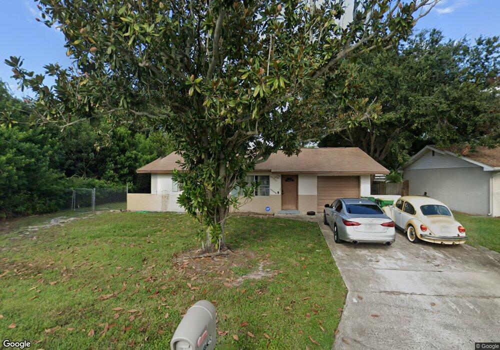
This home is located at 681 Lindsay Ave, Cocoa, FL 32927 and is currently estimated at $234,562, approximately $235 per square foot. 681 Lindsay Ave is a home located in Brevard County with nearby schools including Atlantis Elementary School, Space Coast Junior/Senior High School, and East Atlantic Prep of Brevard County.
Ownership History
Date
Name
Owned For
Owner Type
Purchase Details
Closed on
May 10, 2010
Sold by
Lagana Lagana Nell M Nell M and Lagana Anthony J
Bought by
Greer Derrick A
Current Estimated Value
Home Financials for this Owner
Home Financials are based on the most recent Mortgage that was taken out on this home.
Original Mortgage
$46,805
Outstanding Balance
$31,387
Interest Rate
5.06%
Estimated Equity
$203,175
Purchase Details
Closed on
Sep 27, 1993
Sold by
Lagana Anthony J and Lagana Nell M
Bought by
Lagana Anthony J
Create a Home Valuation Report for This Property
The Home Valuation Report is an in-depth analysis detailing your home's value as well as a comparison with similar homes in the area
Home Values in the Area
Average Home Value in this Area
Purchase History
| Date | Buyer | Sale Price | Title Company |
|---|---|---|---|
| Greer Derrick A | $53,500 | Glow Title & Escrow | |
| Lagana Anthony J | -- | -- |
Source: Public Records
Mortgage History
| Date | Status | Borrower | Loan Amount |
|---|---|---|---|
| Open | Greer Derrick A | $46,805 |
Source: Public Records
Tax History Compared to Growth
Tax History
| Year | Tax Paid | Tax Assessment Tax Assessment Total Assessment is a certain percentage of the fair market value that is determined by local assessors to be the total taxable value of land and additions on the property. | Land | Improvement |
|---|---|---|---|---|
| 2025 | $818 | $51,240 | -- | -- |
| 2024 | $793 | $49,800 | -- | -- |
| 2023 | $793 | $48,350 | $0 | $0 |
| 2022 | $752 | $46,950 | $0 | $0 |
| 2021 | $739 | $45,590 | $0 | $0 |
| 2020 | $700 | $44,970 | $0 | $0 |
| 2019 | $639 | $43,960 | $0 | $0 |
| 2018 | $630 | $43,150 | $0 | $0 |
| 2017 | $620 | $42,270 | $0 | $0 |
| 2016 | $613 | $41,410 | $18,000 | $23,410 |
| 2015 | $608 | $41,130 | $15,000 | $26,130 |
| 2014 | $607 | $40,810 | $11,000 | $29,810 |
Source: Public Records
Map
Nearby Homes
- 641 Lindsay Ave
- 672 Altura Dr
- 780 Alcazar Ave
- 1164 Aron St
- 1108 Vineland St
- 1015 Hibiscus St
- 0 Fay Blvd Unit 1011912
- 6575 Dallas Ave
- 6900 N Highway 1 Unit 6307
- 453 Camel Cir
- 995 Barclay Dr
- 522 Clearview Dr
- 6340 U S Route 1
- 6340 N Highway 1
- 973 Kaufman St
- 520 Arabella Ln
- 961 Kaufman St
- 1008 Jersey St
- 1029 Illinois Rd
- 7000 N Highway 1 Unit 104
- 691 Lindsay Ave
- 671 Lindsay Ave
- 654 Altura Dr
- 661 Lindsay Ave
- 697 Lindsay Ave
- 660 Altura Dr
- 648 Altura Dr
- 680 Lindsay Ave
- 690 Lindsay Ave
- 698 Lindsay Ave
- 700 Lindsay Ave
- 1124 Applin Ln
- 642 Altura Dr
- 651 Lindsay Ave
- 670 Lindsay Ave
- 710 Lindsay Ave
- 664 Altura Dr
- 1156 Applin Ln
- 699 Aloha Ave
- 681 Aloha Ave