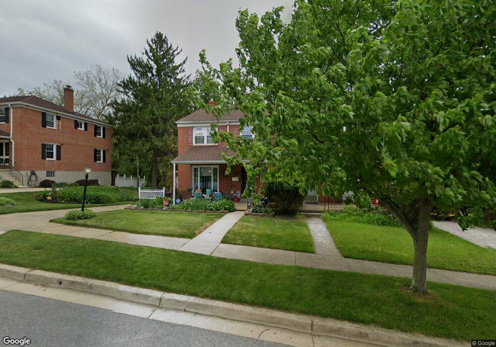
6819 Queens Ferry Rd Baltimore, MD 21239
Estimated Value: $278,000 - $326,000
--
Bed
2
Baths
1,496
Sq Ft
$204/Sq Ft
Est. Value
About This Home
This home is located at 6819 Queens Ferry Rd, Baltimore, MD 21239 and is currently estimated at $305,728, approximately $204 per square foot. 6819 Queens Ferry Rd is a home located in Baltimore County with nearby schools including Halstead Academy, Loch Raven Technical Academy, and Towson High Law & Public Policy.
Ownership History
Date
Name
Owned For
Owner Type
Purchase Details
Closed on
Jan 5, 2009
Sold by
Parker Elizabeth C
Bought by
Parker Elizabeth C
Current Estimated Value
Purchase Details
Closed on
Nov 4, 2008
Sold by
Parker Elizabeth C
Bought by
Parker Elizabeth C
Purchase Details
Closed on
Sep 19, 2001
Sold by
Schreiner Thomas B
Bought by
Parker Elizabeth C
Purchase Details
Closed on
Aug 10, 1970
Sold by
Johnson Ruth M
Bought by
Schreiner Thomas B
Create a Home Valuation Report for This Property
The Home Valuation Report is an in-depth analysis detailing your home's value as well as a comparison with similar homes in the area
Home Values in the Area
Average Home Value in this Area
Purchase History
| Date | Buyer | Sale Price | Title Company |
|---|---|---|---|
| Parker Elizabeth C | -- | -- | |
| Parker Elizabeth C | -- | -- | |
| Parker Elizabeth C | $129,000 | -- | |
| Schreiner Thomas B | $22,000 | -- |
Source: Public Records
Tax History Compared to Growth
Tax History
| Year | Tax Paid | Tax Assessment Tax Assessment Total Assessment is a certain percentage of the fair market value that is determined by local assessors to be the total taxable value of land and additions on the property. | Land | Improvement |
|---|---|---|---|---|
| 2025 | $3,048 | $226,200 | $80,000 | $146,200 |
| 2024 | $3,048 | $216,133 | $0 | $0 |
| 2023 | $1,468 | $206,067 | $0 | $0 |
| 2022 | $2,879 | $196,000 | $80,000 | $116,000 |
| 2021 | $2,691 | $190,433 | $0 | $0 |
| 2020 | $2,691 | $184,867 | $0 | $0 |
| 2019 | $2,811 | $179,300 | $80,000 | $99,300 |
| 2018 | $2,622 | $177,400 | $0 | $0 |
| 2017 | $2,498 | $175,500 | $0 | $0 |
| 2016 | $2,209 | $173,600 | $0 | $0 |
| 2015 | $2,209 | $173,600 | $0 | $0 |
| 2014 | $2,209 | $173,600 | $0 | $0 |
Source: Public Records
Map
Nearby Homes
- 6702 Queens Ferry Rd
- 1204 Saint Andrews Way
- 1108 Litchfield Rd
- 6931 Summit Cir
- 6923 Summit Cir
- 703 Hillen Rd
- 701 Hillen Rd
- 908 Stevenson Ln
- 6415 Falkirk Rd
- 1211 Dalton Rd
- 12 Stone Ridge Ct
- 28 Stone Ridge Ct
- 1304 Dartmouth Ave
- 1316 Dartmouth Ave
- 1602 Glen Keith Blvd
- 1641 Cottage Ln
- 6216 Falkirk Rd
- 1331 Dalton Rd
- 7516 Hillsway Ave
- 6204 Falkirk Rd
- 6817 Queens Ferry Rd
- 6821 Queens Ferry Rd
- 6815 Queens Ferry Rd
- 6823 Queens Ferry Rd
- 6818 Queens Ferry Rd
- 6813 Queens Ferry Rd
- 6822 Queens Ferry Rd
- 6825 Queens Ferry Rd
- 6811 Queens Ferry Rd
- 6827 Queens Ferry Rd
- 6809 Queens Ferry Rd
- 6801 Barnett Rd
- 6826 Queens Ferry Rd
- 6816 Queens Ferry Rd
- 6810 Queens Ferry Rd
- 1303 Crownfield Ct
- 6829 Queens Ferry Rd
- 6828 Queens Ferry Rd
- 6807 Queens Ferry Rd
- 6803 Barnett Rd