Estimated Value: $296,583 - $336,000
3
Beds
2
Baths
1,478
Sq Ft
$214/Sq Ft
Est. Value
About This Home
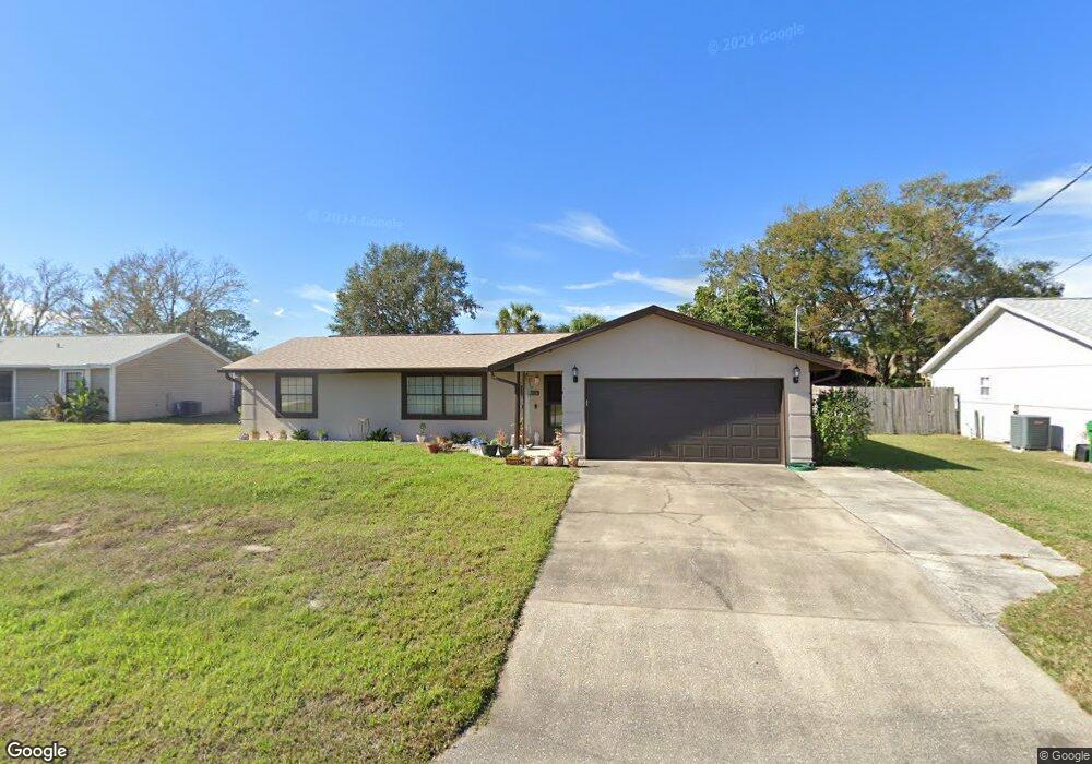
This home is located at 6824 Cecil Rd, Cocoa, FL 32927 and is currently estimated at $316,646, approximately $214 per square foot. 6824 Cecil Rd is a home located in Brevard County with nearby schools including Enterprise Elementary School, Space Coast Junior/Senior High School, and Sculptor Charter School.
Ownership History
Date
Name
Owned For
Owner Type
Purchase Details
Closed on
Dec 11, 2018
Sold by
Holtschulte Carole E
Bought by
Holtschulte Carole E and Carole E Holtschulte Trust
Current Estimated Value
Purchase Details
Closed on
Sep 15, 2016
Sold by
Wilies Craig L
Bought by
Holtschlte Carole E
Home Financials for this Owner
Home Financials are based on the most recent Mortgage that was taken out on this home.
Original Mortgage
$90,000
Outstanding Balance
$71,889
Interest Rate
3.43%
Mortgage Type
New Conventional
Estimated Equity
$244,757
Purchase Details
Closed on
Apr 7, 2005
Sold by
Holtschulte Carole E and Wiles Elmer D
Bought by
Holtschulte Carole E
Create a Home Valuation Report for This Property
The Home Valuation Report is an in-depth analysis detailing your home's value as well as a comparison with similar homes in the area
Home Values in the Area
Average Home Value in this Area
Purchase History
| Date | Buyer | Sale Price | Title Company |
|---|---|---|---|
| Holtschulte Carole E | -- | Attorney | |
| Holtschlte Carole E | $45,000 | Fidelity National Title | |
| Holtschulte Carole E | -- | -- |
Source: Public Records
Mortgage History
| Date | Status | Borrower | Loan Amount |
|---|---|---|---|
| Open | Holtschlte Carole E | $90,000 |
Source: Public Records
Tax History
| Year | Tax Paid | Tax Assessment Tax Assessment Total Assessment is a certain percentage of the fair market value that is determined by local assessors to be the total taxable value of land and additions on the property. | Land | Improvement |
|---|---|---|---|---|
| 2025 | $1,169 | $82,840 | -- | -- |
| 2024 | $1,133 | $80,510 | -- | -- |
| 2023 | $1,133 | $78,170 | $0 | $0 |
| 2022 | $1,053 | $75,900 | $0 | $0 |
| 2021 | $1,049 | $73,690 | $0 | $0 |
| 2020 | $991 | $72,680 | $0 | $0 |
| 2019 | $938 | $71,050 | $0 | $0 |
| 2018 | $938 | $69,730 | $0 | $0 |
| 2017 | $938 | $68,300 | $0 | $0 |
| 2016 | $946 | $66,900 | $18,000 | $48,900 |
| 2015 | $954 | $66,440 | $15,000 | $51,440 |
| 2014 | $959 | $65,920 | $11,000 | $54,920 |
Source: Public Records
Map
Nearby Homes
- 6815 Bryant Rd
- 6760 Cairo Rd
- 5155 Mayflower St
- 5095 Hogan Place
- 7065 Hundred Acre Dr
- 5165 Patricia St
- 6990 Bryant Rd
- 6615 Dock Ave
- 5080 Mayflower St
- 5555 Brandon St
- 6620 Grissom Pkwy
- 00 Unknown
- 6450 Ember Ave
- 5200 Frisco St
- 7155 Export Ave
- 6581 Bancroft Ave
- 7230 Venus Ave
- 0000 Grissom Pkwy
- 4824 Curtis Blvd
- 4852 Alfred St
Your Personal Tour Guide
Ask me questions while you tour the home.