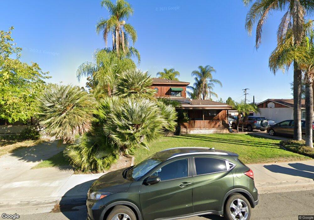
686 Grant Ave El Cajon, CA 92020
Estimated Value: $847,000 - $1,031,000
3
Beds
2
Baths
2,166
Sq Ft
$436/Sq Ft
Est. Value
About This Home
This home is located at 686 Grant Ave, El Cajon, CA 92020 and is currently estimated at $944,759, approximately $436 per square foot. 686 Grant Ave is a home located in San Diego County with nearby schools including Chase Avenue Elementary School, Cajon Valley Middle School, and Grossmont High School.
Ownership History
Date
Name
Owned For
Owner Type
Purchase Details
Closed on
May 1, 2012
Sold by
Dale Julie G and Dale Richard H
Bought by
Dale Julie G and Dale Richard H
Current Estimated Value
Purchase Details
Closed on
Jul 23, 2004
Sold by
Clark Hal M and Clark Susan J
Bought by
Dale Richard H and Dale Julie G
Home Financials for this Owner
Home Financials are based on the most recent Mortgage that was taken out on this home.
Original Mortgage
$215,000
Interest Rate
5.8%
Mortgage Type
Purchase Money Mortgage
Purchase Details
Closed on
Jul 19, 1993
Sold by
Novell William Eugene
Bought by
Clark Hal M and Clark Susan J
Home Financials for this Owner
Home Financials are based on the most recent Mortgage that was taken out on this home.
Original Mortgage
$184,000
Interest Rate
7.2%
Mortgage Type
VA
Create a Home Valuation Report for This Property
The Home Valuation Report is an in-depth analysis detailing your home's value as well as a comparison with similar homes in the area
Purchase History
| Date | Buyer | Sale Price | Title Company |
|---|---|---|---|
| Dale Julie G | -- | None Available | |
| Dale Richard H | $570,000 | Commonwealth Land Title Co | |
| Clark Hal M | $190,000 | Orange Coast Title Company |
Source: Public Records
Mortgage History
| Date | Status | Borrower | Loan Amount |
|---|---|---|---|
| Previous Owner | Dale Richard H | $215,000 | |
| Previous Owner | Clark Hal M | $184,000 |
Source: Public Records
Tax History
| Year | Tax Paid | Tax Assessment Tax Assessment Total Assessment is a certain percentage of the fair market value that is determined by local assessors to be the total taxable value of land and additions on the property. | Land | Improvement |
|---|---|---|---|---|
| 2025 | $10,291 | $794,463 | $452,984 | $341,479 |
| 2024 | $10,291 | $778,886 | $444,102 | $334,784 |
| 2023 | $10,380 | $763,615 | $435,395 | $328,220 |
| 2022 | $10,253 | $748,643 | $426,858 | $321,785 |
| 2021 | $8,798 | $600,000 | $339,000 | $261,000 |
| 2020 | $7,005 | $550,000 | $311,000 | $239,000 |
| 2019 | $6,030 | $500,000 | $283,000 | $217,000 |
| 2018 | $5,807 | $480,000 | $272,000 | $208,000 |
| 2017 | $5,847 | $480,000 | $272,000 | $208,000 |
| 2016 | $5,425 | $455,000 | $258,000 | $197,000 |
| 2015 | $5,054 | $420,000 | $239,000 | $181,000 |
| 2014 | $4,690 | $390,000 | $222,000 | $168,000 |
Source: Public Records
Map
Nearby Homes
- 726 Paulsen Ave
- 686 Van Houten Ave
- 855 Franklin Ave Unit 57
- 1000 Estes St Unit 44
- 1000 Estes St Unit 35
- 403 Emerald Ave Unit 8
- 652 S Orange Ave
- 1069 Estes St
- 1111 Boulevard Place
- 1178 Eucalyptus Dr
- 1002 W Chase Ave
- 306 Richardson Ave Unit 10
- 545 Sandstone Ct
- 514 Cobblestone Ct
- 508 Cobblestone Ct
- 261 Gateway Ct
- 154 Lindell Ave
- 333 W Lexington Ave Unit D
- 520 Cobblestone Ct
- 513 Sandstone Ct
- 694 Grant Ave
- 670 Grant Ave
- 775 S Johnson Ave
- 658 Grant Ave
- 675 Patricia Ln
- 689 Patricia Ln
- 661 Patricia Ln
- 697 Patricia Ln
- 649 Patricia Ln
- 644 Grant Ave
- 631 Patricia Ln
- 630 Grant Ave
- 623 Patricia Ln
- 758 S Johnson Ave
- 614 Grant Ave
- 735 Grant Ave
- 688 Patricia Ln
- 760 S Johnson Ave
- 672 Patricia Ln
- 692 Patricia Ln
Your Personal Tour Guide
Ask me questions while you tour the home.