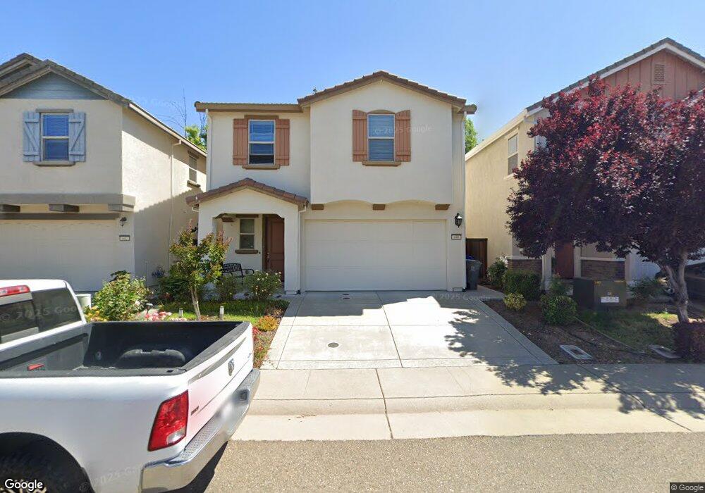
688 Addison Ln Folsom, CA 95630
Estimated Value: $605,865 - $714,000
4
Beds
3
Baths
1,904
Sq Ft
$347/Sq Ft
Est. Value
About This Home
This home is located at 688 Addison Ln, Folsom, CA 95630 and is currently estimated at $661,216, approximately $347 per square foot. 688 Addison Ln is a home with nearby schools including Natoma Station Elementary School, Sutter Middle School, and Folsom High School.
Ownership History
Date
Name
Owned For
Owner Type
Purchase Details
Closed on
Sep 6, 2024
Sold by
Balachandran Ranjith and Murugan Gnanambigai Kirthika
Bought by
Balachandran Family Revocable Living Trust and Balachandran
Current Estimated Value
Purchase Details
Closed on
Feb 9, 2016
Sold by
Addison Place 38 Llc
Bought by
Balachandran Ranjith and Murugan Gnanambigal K
Home Financials for this Owner
Home Financials are based on the most recent Mortgage that was taken out on this home.
Original Mortgage
$403,948
Interest Rate
3.37%
Mortgage Type
FHA
Create a Home Valuation Report for This Property
The Home Valuation Report is an in-depth analysis detailing your home's value as well as a comparison with similar homes in the area
Purchase History
| Date | Buyer | Sale Price | Title Company |
|---|---|---|---|
| Balachandran Family Revocable Living Trust | -- | None Listed On Document | |
| Balachandran Ranjith | $411,500 | Stewart Title Of Sacramento |
Source: Public Records
Mortgage History
| Date | Status | Borrower | Loan Amount |
|---|---|---|---|
| Previous Owner | Balachandran Ranjith | $403,948 |
Source: Public Records
Tax History
| Year | Tax Paid | Tax Assessment Tax Assessment Total Assessment is a certain percentage of the fair market value that is determined by local assessors to be the total taxable value of land and additions on the property. | Land | Improvement |
|---|---|---|---|---|
| 2025 | $5,487 | $491,860 | $153,891 | $337,969 |
| 2024 | $5,487 | $482,217 | $150,874 | $331,343 |
| 2023 | $5,364 | $472,763 | $147,916 | $324,847 |
| 2022 | $5,288 | $463,494 | $145,016 | $318,478 |
| 2021 | $5,220 | $454,407 | $142,173 | $312,234 |
| 2020 | $5,158 | $449,749 | $140,716 | $309,033 |
| 2019 | $5,076 | $440,931 | $137,957 | $302,974 |
| 2018 | $4,949 | $432,286 | $135,252 | $297,034 |
| 2017 | $4,627 | $423,810 | $132,600 | $291,210 |
| 2016 | $637 | $34,215 | $34,215 | $0 |
| 2015 | $532 | $33,702 | $33,702 | $0 |
| 2014 | $511 | $33,042 | $33,042 | $0 |
Source: Public Records
Map
Nearby Homes
- 682 Diamond Glen Cir
- 701 Ferrier Way
- 448 Gem Smith Place
- 467 Facet Place
- 108 Austin Dr
- 683 Loomis Cir
- 1002 Sibley St Unit 25
- 692 Humbert St
- 115 McNamee Dr
- 206 Oxburough Dr
- 401 Seaton Dr
- 112 Hazelmere Dr
- 607 Sibley St
- 120 Elkins Cir
- 424 Wellsley Ct
- 632 Fisher Cir
- 145 Hopfield Dr
- 110 Conductor Way
- 306 Dean Way
- 219 Needles Way
Your Personal Tour Guide
Ask me questions while you tour the home.