Estimated Value: $250,648 - $302,000
3
Beds
2
Baths
1,320
Sq Ft
$211/Sq Ft
Est. Value
About This Home
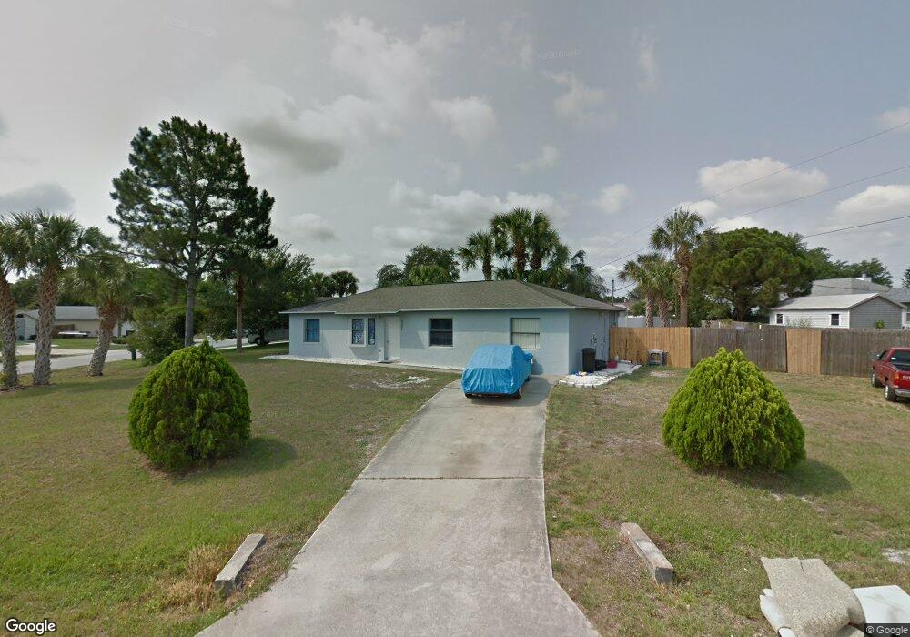
This home is located at 6880 Cairo Rd, Cocoa, FL 32927 and is currently estimated at $277,912, approximately $210 per square foot. 6880 Cairo Rd is a home located in Brevard County with nearby schools including Enterprise Elementary School, Space Coast Junior/Senior High School, and Sculptor Charter School.
Ownership History
Date
Name
Owned For
Owner Type
Purchase Details
Closed on
Feb 12, 2015
Sold by
Darling Jeannette
Bought by
Darling William H and Darling Jennette
Current Estimated Value
Purchase Details
Closed on
Dec 16, 2011
Sold by
Darling Jennette
Bought by
Darling William H and Darling Jennette
Purchase Details
Closed on
Jan 11, 2011
Sold by
Aurora Loan Services Llc
Bought by
Darling Jeannette
Purchase Details
Closed on
Aug 2, 2010
Sold by
Wilson Robert and Circuit Court For Brevard Coun
Bought by
Aurora Loan Services Llc
Purchase Details
Closed on
Jan 19, 2007
Sold by
Boulay Paul A and Boulay Janita D
Bought by
Wilson Robert
Home Financials for this Owner
Home Financials are based on the most recent Mortgage that was taken out on this home.
Original Mortgage
$139,000
Interest Rate
6.05%
Create a Home Valuation Report for This Property
The Home Valuation Report is an in-depth analysis detailing your home's value as well as a comparison with similar homes in the area
Home Values in the Area
Average Home Value in this Area
Purchase History
| Date | Buyer | Sale Price | Title Company |
|---|---|---|---|
| Darling William H | -- | Attorney | |
| Darling William H | -- | None Available | |
| Darling Jeannette | $41,000 | Attorney | |
| Aurora Loan Services Llc | -- | None Available | |
| Wilson Robert | $139,000 | Security First Title Partner |
Source: Public Records
Mortgage History
| Date | Status | Borrower | Loan Amount |
|---|---|---|---|
| Previous Owner | Wilson Robert | $139,000 |
Source: Public Records
Tax History
| Year | Tax Paid | Tax Assessment Tax Assessment Total Assessment is a certain percentage of the fair market value that is determined by local assessors to be the total taxable value of land and additions on the property. | Land | Improvement |
|---|---|---|---|---|
| 2025 | $1,146 | $85,900 | -- | -- |
| 2024 | $1,111 | $83,480 | -- | -- |
| 2023 | $1,111 | $81,050 | $0 | $0 |
| 2022 | $1,031 | $78,690 | $0 | $0 |
| 2021 | $1,019 | $76,400 | $0 | $0 |
| 2020 | $966 | $75,350 | $0 | $0 |
| 2019 | $911 | $73,660 | $0 | $0 |
| 2018 | $913 | $72,290 | $0 | $0 |
| 2017 | $915 | $70,810 | $0 | $0 |
| 2016 | $924 | $69,360 | $18,000 | $51,360 |
| 2015 | $1,000 | $60,010 | $15,000 | $45,010 |
| 2014 | $930 | $56,790 | $11,000 | $45,790 |
Source: Public Records
Map
Nearby Homes
- 6815 Bryant Rd
- 6760 Cairo Rd
- 7065 Hundred Acre Dr
- 6990 Bryant Rd
- 5155 Mayflower St
- 5165 Patricia St
- 5555 Brandon St
- 5075 Carter St
- 6615 Dock Ave
- 5080 Mayflower St
- 7230 Venus Ave
- 00 Unknown
- 6620 Grissom Pkwy
- 5200 Frisco St
- 6581 Bancroft Ave
- 6450 Ember Ave
- 5680 Brandon St
- 7045 Grissom Pkwy
- 7155 Export Ave
- 7200 Oakwood Ave
Your Personal Tour Guide
Ask me questions while you tour the home.