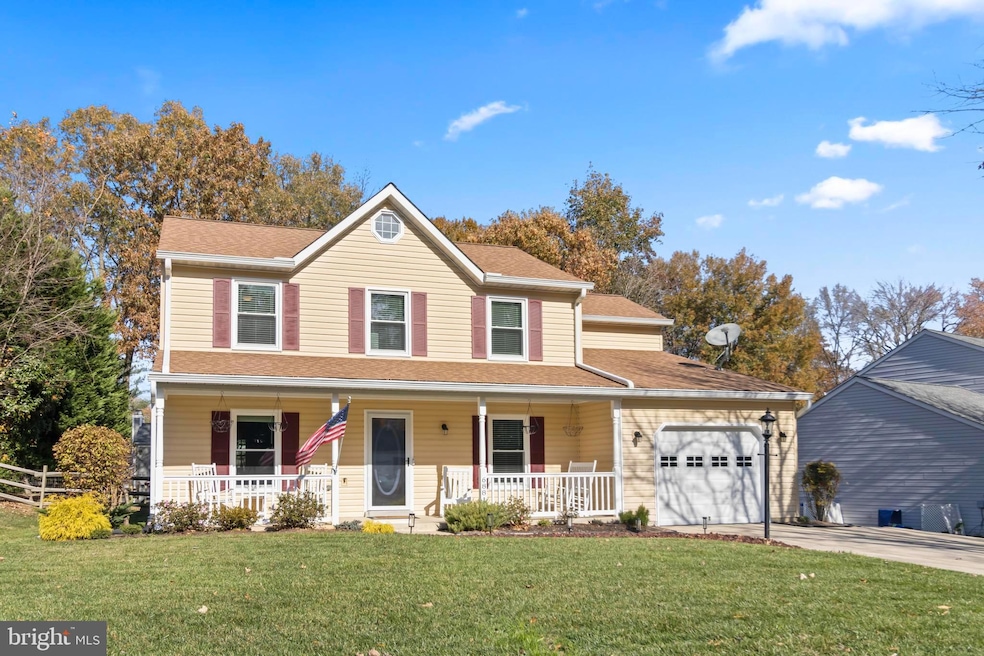


6881 Kangaroo Dr Waldorf, MD 20603
Estimated payment $2,676/month
Highlights
- Colonial Architecture
- Tennis Courts
- 1 Car Attached Garage
- Community Pool
- Community Center
- Double Pane Windows
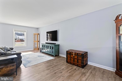
About This Home
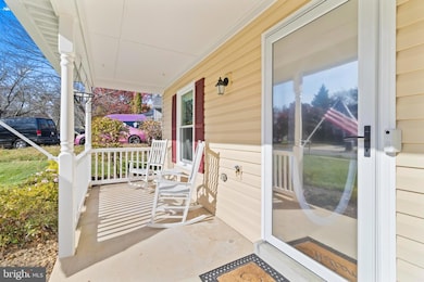
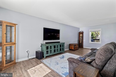
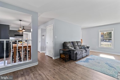
Nestled in the Hampshire Subdivision, this Colonial-style home offers a perfect blend of comfort and community. With 1,776 square feet of living space, this residence features four spacious bedrooms and two and a half bathrooms, making it an ideal retreat for those seeking a warm and inviting atmosphere. Step inside to discover a well-appointed kitchen equipped with modern appliances, including a new, self-cleaning oven, electric range, dishwasher, and new refrigerator. The open layout seamlessly connects the kitchen to the living area that beckons you to unwind after a long day. The office space with french doors on the main level is the perfect work from home situation. The double-pane windows not only enhance energy efficiency but also fill the home with natural light, creating a bright and cheerful ambiance. The exterior of the home is equally appealing, set on a level 0.23-acre lot with a large deck that provides ample space for outdoor activities and gatherings. Enjoy the community amenities, including an outdoor pool, tennis courts, and a community center, perfect for socializing and making lasting memories. The neighborhood is conveniently located within five miles of commuter lots, making your daily travels a breeze. The local schools are known for their commitment to excellence, learning and growth. Public services in the area are top-notch, ensuring that residents have access to everything they need for a comfortable lifestyle. Even if you are simply relaxing in your backyard, this home offers a sense of belonging and tranquility. With an attached garage featuring a garage door opener, parking is convenient and hassle-free. This property is not just a house; it's a place where memories are made, and where you can truly feel at home. Experience the warmth and charm of the Hampshire Neighborhood-your new beginning awaits!
Listing Agent
(301) 752-6149 TynaLucke@gmail.com CENTURY 21 New Millennium License #529471 Listed on: 11/10/2025

Home Details
Home Type
- Single Family
Est. Annual Taxes
- $4,685
Year Built
- Built in 1988
Lot Details
- 10,019 Sq Ft Lot
- Level Lot
- Property is in very good condition
- Property is zoned PUD
HOA Fees
- $50 Monthly HOA Fees
Parking
- 1 Car Attached Garage
- Garage Door Opener
Home Design
- Colonial Architecture
- Asphalt Roof
- Vinyl Siding
Interior Spaces
- 1,776 Sq Ft Home
- Property has 2 Levels
- Double Pane Windows
- Window Screens
- French Doors
- Sliding Doors
- Six Panel Doors
- Crawl Space
Kitchen
- Electric Oven or Range
- Self-Cleaning Oven
- Stove
- Ice Maker
- Dishwasher
- Disposal
Bedrooms and Bathrooms
- 4 Bedrooms
Laundry
- Dryer
- Washer
Schools
- William B Wade Elementary School
- Theodore G. Davis Middle School
- Westlake High School
Utilities
- Forced Air Heating System
- Heat Pump System
- Vented Exhaust Fan
- Electric Water Heater
Listing and Financial Details
- Tax Lot 51
- Assessor Parcel Number 0906174159
Community Details
Overview
- Built by FOLTYN
- Westlake Village Subdivision, Chesley Floorplan
Amenities
- Community Center
Recreation
- Tennis Courts
- Community Pool
Map
Home Values in the Area
Average Home Value in this Area
Tax History
| Year | Tax Paid | Tax Assessment Tax Assessment Total Assessment is a certain percentage of the fair market value that is determined by local assessors to be the total taxable value of land and additions on the property. | Land | Improvement |
|---|---|---|---|---|
| 2025 | $10,346 | $338,867 | -- | -- |
| 2024 | $4,585 | $323,700 | $125,300 | $198,400 |
| 2023 | $4,371 | $305,900 | $0 | $0 |
| 2022 | $4,062 | $288,100 | $0 | $0 |
| 2021 | $3,637 | $270,300 | $96,300 | $174,000 |
| 2020 | $3,637 | $259,200 | $0 | $0 |
| 2019 | $3,475 | $248,100 | $0 | $0 |
| 2018 | $3,288 | $237,000 | $90,300 | $146,700 |
| 2017 | $3,146 | $226,767 | $0 | $0 |
| 2016 | -- | $216,533 | $0 | $0 |
| 2015 | $2,858 | $206,300 | $0 | $0 |
| 2014 | $2,858 | $206,300 | $0 | $0 |
Property History
| Date | Event | Price | List to Sale | Price per Sq Ft |
|---|---|---|---|---|
| 11/10/2025 11/10/25 | For Sale | $425,000 | -- | $239 / Sq Ft |
Purchase History
| Date | Type | Sale Price | Title Company |
|---|---|---|---|
| Deed | $335,000 | -- | |
| Deed | $120,100 | -- | |
| Deed | $387,000 | -- |
Mortgage History
| Date | Status | Loan Amount | Loan Type |
|---|---|---|---|
| Open | $335,000 | New Conventional | |
| Previous Owner | $309,600 | No Value Available |
Source: Bright MLS
MLS Number: MDCH2048976
APN: 06-174159
Disclaimer: Certain information contained herein is derived from information provided by parties other than Homes.com. All information provided is deemed reliable, but is not guaranteed to be accurate and should be independently verified.
![]() The data relating to real estate for sale on this website appears in part through the BRIGHT Internet Data Exchange program, a voluntary cooperative exchange of property listing data between licensed real estate brokerage firms, and is provided by BRIGHT through a licensing agreement.
The data relating to real estate for sale on this website appears in part through the BRIGHT Internet Data Exchange program, a voluntary cooperative exchange of property listing data between licensed real estate brokerage firms, and is provided by BRIGHT through a licensing agreement.
Listing information is from various brokers who participate in the Bright MLS IDX program and not all listings may be visible on the site.
The property information being provided on or through the website is for the personal, non-commercial use of consumers and such information may not be used for any purpose other than to identify prospective properties consumers may be interested in purchasing.
Some properties which appear for sale on the website may no longer be available because they are for instance, under contract, sold or are no longer being offered for sale.
Property information displayed is deemed reliable but is not guaranteed.
Copyright 2025 Bright MLS, Inc.
- 6105 Pooka Ct
- 6221 Polar Bear Ct
- 6814 Jaguar Ct
- 10583 Frasier Fir Ln
- 10427 Stone Pine Ave
- 9661 Bergamont Ct
- 6016 Harbor Seal Ct
- 6094 Red Squirrel Place
- 6829 Cologo Ct
- 6114 Red Squirrel Place
- 6343 Goral Ct
- 3264 Gossett Ct
- 6836 Cologo Ct
- 6140 Sea Lion Place
- 6101 Tapir Place
- 3097 Miranda Place
- 9706 Cadwell St
- 6302 Whistlers Place
- 10750 Sourwood Ave
- 10456 Markby Ct
- 6306 Panda Ct
- 6304 Cheetah Ct
- 6610 Cottontail Ct
- 10425 Starlight Place
- 6001 New Forest Ct
- 6061 Thoroughbred Ct
- 4818 Kingfisher Ct
- 5097 Bluehead Ct
- 4001 Night Heron Ct
- 5001 Pupfish Ct
- 4651 Grosbeak Place
- 4136 Falcon Place
- 11488 Mary Shelley Place
- 4120 Lancaster Cir
- 10891 Saint Patricks Park Aly
- 4038 Bluebird Dr
- 3560 Malvern St
- 10886 Moore St
- 2555 Avesta Place
- 11060 Weymouth Ct