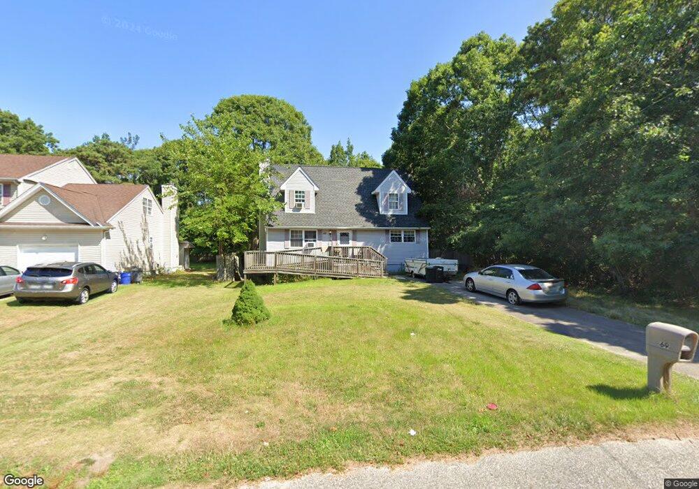
69 Palmetto Dr Shirley, NY 11967
Estimated Value: $327,000 - $541,000
3
Beds
2
Baths
1,341
Sq Ft
$354/Sq Ft
Est. Value
About This Home
This home is located at 69 Palmetto Dr, Shirley, NY 11967 and is currently estimated at $475,346, approximately $354 per square foot. 69 Palmetto Dr is a home located in Suffolk County with nearby schools including John S. Hobart Elementary School, William Paca Middle School, and William Floyd High School.
Ownership History
Date
Name
Owned For
Owner Type
Purchase Details
Closed on
Sep 18, 2002
Sold by
Smith Robert K and Smith Nancy Lee
Bought by
Malvagno Robert and Malvagno Cynthia
Current Estimated Value
Home Financials for this Owner
Home Financials are based on the most recent Mortgage that was taken out on this home.
Original Mortgage
$180,000
Outstanding Balance
$75,192
Interest Rate
6.24%
Estimated Equity
$400,154
Purchase Details
Closed on
Mar 12, 2001
Sold by
Tnt Development Group Of Long Island Llc
Bought by
Malvagno Robert and Smith Robert K
Home Financials for this Owner
Home Financials are based on the most recent Mortgage that was taken out on this home.
Original Mortgage
$120,607
Interest Rate
6.96%
Mortgage Type
FHA
Purchase Details
Closed on
Sep 1, 1998
Sold by
Racanelli Frank N
Bought by
Tnt Development Group Of Ii Llc
Create a Home Valuation Report for This Property
The Home Valuation Report is an in-depth analysis detailing your home's value as well as a comparison with similar homes in the area
Home Values in the Area
Average Home Value in this Area
Purchase History
| Date | Buyer | Sale Price | Title Company |
|---|---|---|---|
| Malvagno Robert | -- | -- | |
| Malvagno Robert | $122,000 | Stewart Title Insurance Co | |
| Tnt Development Group Of Ii Llc | $15,200 | -- |
Source: Public Records
Mortgage History
| Date | Status | Borrower | Loan Amount |
|---|---|---|---|
| Open | Malvagno Robert | $180,000 | |
| Closed | Malvagno Robert | $120,607 |
Source: Public Records
Tax History Compared to Growth
Tax History
| Year | Tax Paid | Tax Assessment Tax Assessment Total Assessment is a certain percentage of the fair market value that is determined by local assessors to be the total taxable value of land and additions on the property. | Land | Improvement |
|---|---|---|---|---|
| 2024 | $6,756 | $1,900 | $160 | $1,740 |
| 2023 | $6,756 | $1,900 | $160 | $1,740 |
| 2022 | $3,349 | $1,900 | $160 | $1,740 |
| 2021 | $3,349 | $1,900 | $160 | $1,740 |
| 2020 | $3,477 | $1,900 | $160 | $1,740 |
| 2019 | $3,477 | $0 | $0 | $0 |
| 2018 | $6,882 | $1,900 | $160 | $1,740 |
| 2017 | $6,882 | $1,900 | $160 | $1,740 |
| 2016 | $6,859 | $1,900 | $160 | $1,740 |
| 2015 | -- | $1,900 | $160 | $1,740 |
| 2014 | -- | $1,900 | $160 | $1,740 |
Source: Public Records
Map
Nearby Homes
- 71 Palmetto Dr
- 74 Palmetto Dr
- 305 Commack Rd
- 38 Johns Neck Rd
- 55 Pinewood Dr
- 279 Commack Rd
- 277 Commack Rd
- 40 Pinewood Dr
- N/C Fairview Dr
- 9 Brushwood Dr
- 31 Harrison Dr
- 344 Elm Rd W
- 96 Baybright Dr
- 27 Pinewood Dr
- 205 William Floyd Pkwy
- 94 Baybright Dr E
- 30 Johns Neck Rd
- 6 Bogota Rd
- 516 Neighborhood Rd
- 514 Neighborhood Rd