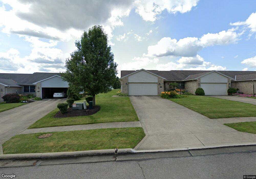
69 Shaffner Blvd Mansfield, OH 44907
Estimated Value: $233,000 - $244,000
3
Beds
2
Baths
1,591
Sq Ft
$150/Sq Ft
Est. Value
About This Home
This home is located at 69 Shaffner Blvd, Mansfield, OH 44907 and is currently estimated at $238,836, approximately $150 per square foot. 69 Shaffner Blvd is a home located in Richland County with nearby schools including Mansfield Christian School, St. Peter's Elementary/Montessori School, and St. Peter's Junior High / High School.
Ownership History
Date
Name
Owned For
Owner Type
Purchase Details
Closed on
Jul 8, 2019
Sold by
Reed Patrick J
Bought by
Shumway Charles A and Reed Preservation Family Trust
Current Estimated Value
Purchase Details
Closed on
Sep 2, 1999
Sold by
Shaffner Enterprises Inc
Bought by
Reed John L and Reed Patricia J
Home Financials for this Owner
Home Financials are based on the most recent Mortgage that was taken out on this home.
Original Mortgage
$55,000
Interest Rate
7.59%
Mortgage Type
New Conventional
Create a Home Valuation Report for This Property
The Home Valuation Report is an in-depth analysis detailing your home's value as well as a comparison with similar homes in the area
Home Values in the Area
Average Home Value in this Area
Purchase History
| Date | Buyer | Sale Price | Title Company |
|---|---|---|---|
| Shumway Charles A | -- | None Available | |
| Reed John L | $126,000 | -- |
Source: Public Records
Mortgage History
| Date | Status | Borrower | Loan Amount |
|---|---|---|---|
| Closed | Reed John L | $55,000 |
Source: Public Records
Tax History
| Year | Tax Paid | Tax Assessment Tax Assessment Total Assessment is a certain percentage of the fair market value that is determined by local assessors to be the total taxable value of land and additions on the property. | Land | Improvement |
|---|---|---|---|---|
| 2024 | $2,931 | $64,020 | $5,820 | $58,200 |
| 2023 | $2,998 | $64,020 | $5,820 | $58,200 |
| 2022 | $2,707 | $48,450 | $4,920 | $43,530 |
| 2021 | $2,726 | $48,450 | $4,920 | $43,530 |
| 2020 | $2,787 | $48,450 | $4,920 | $43,530 |
| 2019 | $2,618 | $41,060 | $4,170 | $36,890 |
| 2018 | $2,582 | $41,060 | $4,170 | $36,890 |
| 2017 | $2,439 | $41,060 | $4,170 | $36,890 |
| 2016 | $2,366 | $37,490 | $2,210 | $35,280 |
| 2015 | $2,260 | $37,490 | $2,210 | $35,280 |
| 2014 | $2,230 | $37,490 | $2,210 | $35,280 |
| 2012 | $850 | $37,490 | $2,210 | $35,280 |
Source: Public Records
Map
Nearby Homes
- 104 Elmridge Rd
- 33 Rambleside Dr
- 1179 Burkwood Rd
- 65 Logan Rd
- 0 Lexington Ave Unit 224009661
- 101 Chilton Ave
- 50 Lilac Ct E
- 400 James Ave
- 0 George Ave
- 1599 S Main St
- 489 Clifton Blvd
- 810 Lexington Ave
- 575 Crescent Rd
- 470 Lexington Ave
- 466 Lexington Ave
- 456 Lexington Ave
- 794 Mansfield Washington Rd
- 716 Mansfield Washington Rd
- 537 Woodville Rd
- 695 S Andover Rd
- 71 Shaffner Blvd Unit 12
- 65 Shaffner Blvd Unit 10
- 73 Shaffner Blvd Unit 13
- 63 Shaffner Blvd Unit 9
- 61 Shaffner Blvd
- 74 Mccullough Blvd Unit 33
- 72 Mccullough Blvd Unit 34
- 56 Mccullough Blvd Unit 41
- 70 Mccullough Blvd Unit 35
- 58 Mccullough Blvd Unit 40
- 59 Shaffner Blvd
- 64 Mccullough Blvd Unit 37
- 68 Mccullough Blvd Unit 36
- 68 Shaffner Blvd Unit 1
- 70 Shaffner Blvd
- 1081 Malabar Ln
- 60 Mccullough Blvd Unit 39
- 62 Mccullough Blvd Unit 38
- 72 Shaffner Blvd
- 1079 Malabar Ln
Your Personal Tour Guide
Ask me questions while you tour the home.