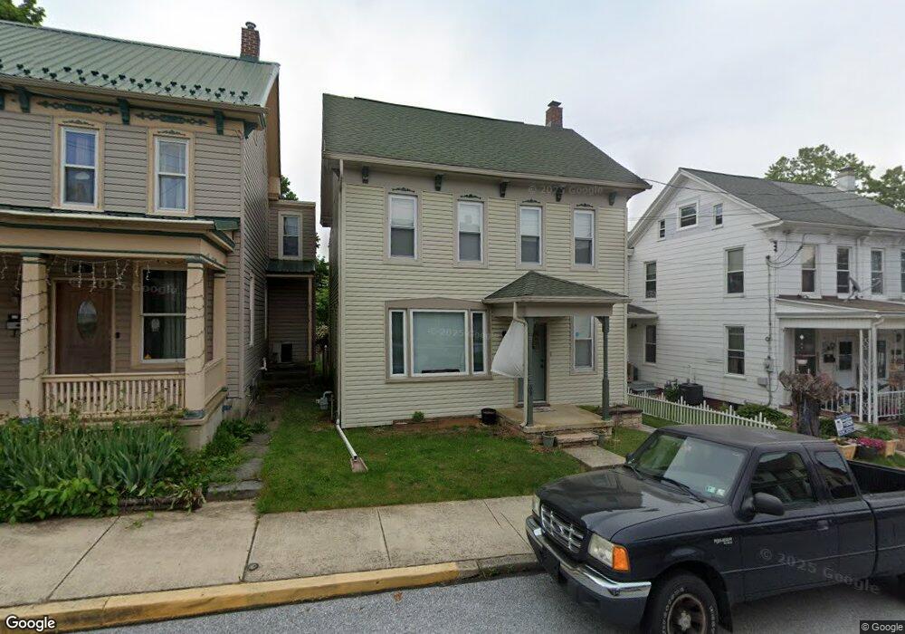
69 W Maple St Unit 144 Dallastown, PA 17313
Estimated Value: $200,000 - $217,000
3
Beds
2
Baths
1,296
Sq Ft
$162/Sq Ft
Est. Value
About This Home
This home is located at 69 W Maple St Unit 144, Dallastown, PA 17313 and is currently estimated at $210,584, approximately $162 per square foot. 69 W Maple St Unit 144 is a home located in York County with nearby schools including Dallastown Elementary School, Dallastown Area Middle School, and Dallastown Area High School.
Ownership History
Date
Name
Owned For
Owner Type
Purchase Details
Closed on
May 16, 2025
Sold by
Pavlick Kimberly A and Ruiz Rafael
Bought by
Kuntz Emily Elizabeth and Vanfleet Foster Robert
Current Estimated Value
Home Financials for this Owner
Home Financials are based on the most recent Mortgage that was taken out on this home.
Original Mortgage
$189,000
Outstanding Balance
$188,354
Interest Rate
6.83%
Mortgage Type
New Conventional
Estimated Equity
$22,230
Purchase Details
Closed on
Mar 31, 2009
Sold by
Heath Stella A
Bought by
Pavlick Kimberly A
Home Financials for this Owner
Home Financials are based on the most recent Mortgage that was taken out on this home.
Original Mortgage
$116,844
Interest Rate
4.92%
Mortgage Type
FHA
Purchase Details
Closed on
Jun 14, 2002
Sold by
Eller John L
Bought by
Heath Stella A
Home Financials for this Owner
Home Financials are based on the most recent Mortgage that was taken out on this home.
Original Mortgage
$74,900
Interest Rate
6.82%
Create a Home Valuation Report for This Property
The Home Valuation Report is an in-depth analysis detailing your home's value as well as a comparison with similar homes in the area
Home Values in the Area
Average Home Value in this Area
Purchase History
| Date | Buyer | Sale Price | Title Company |
|---|---|---|---|
| Kuntz Emily Elizabeth | $210,000 | None Listed On Document | |
| Pavlick Kimberly A | $119,000 | None Available | |
| Heath Stella A | $94,900 | -- |
Source: Public Records
Mortgage History
| Date | Status | Borrower | Loan Amount |
|---|---|---|---|
| Open | Kuntz Emily Elizabeth | $189,000 | |
| Previous Owner | Pavlick Kimberly A | $116,844 | |
| Previous Owner | Heath Stella A | $74,900 |
Source: Public Records
Tax History Compared to Growth
Tax History
| Year | Tax Paid | Tax Assessment Tax Assessment Total Assessment is a certain percentage of the fair market value that is determined by local assessors to be the total taxable value of land and additions on the property. | Land | Improvement |
|---|---|---|---|---|
| 2025 | $2,954 | $85,040 | $21,220 | $63,820 |
| 2024 | $2,954 | $85,040 | $21,220 | $63,820 |
| 2023 | $2,954 | $85,040 | $21,220 | $63,820 |
| 2022 | $2,860 | $85,040 | $21,220 | $63,820 |
| 2021 | $2,697 | $85,040 | $21,220 | $63,820 |
| 2020 | $2,697 | $85,040 | $21,220 | $63,820 |
| 2019 | $2,688 | $85,040 | $21,220 | $63,820 |
| 2018 | $2,688 | $85,040 | $21,220 | $63,820 |
| 2017 | $2,584 | $85,040 | $21,220 | $63,820 |
| 2016 | $0 | $85,040 | $21,220 | $63,820 |
| 2015 | -- | $85,040 | $21,220 | $63,820 |
| 2014 | -- | $85,040 | $21,220 | $63,820 |
Source: Public Records
Map
Nearby Homes
- 263 W Main St
- 18 E Howard St
- 53 S Franklin St
- 79 S Franklin St
- 197 S Main St
- 430 E Maple St
- 117 S Park St
- 74 S Main St
- 2981 Sunset Dr
- 141 W Water St
- 1 N Duke St
- 0 Lot 15 Gary Dr
- 705 Summit Dr
- 114 Heather Glen Dr
- 227 Jutland Way
- 630 Woodland Ave
- 2960 Starfire Dr
- 680 Hampstead Ct
- 55 Belmar Dr
- 260 Country Ridge Dr